



Vexcel Launches Roadway Attributes for 3,300+ Cities Across U.S.
 Tweet
Tweet Share
Share E-mail
- New automated roadway inventory and condition ratings help transportation planners make roadways safer
- More than 30 attributes available to identify, map, and inventory roadway infrastructure and pavement markings
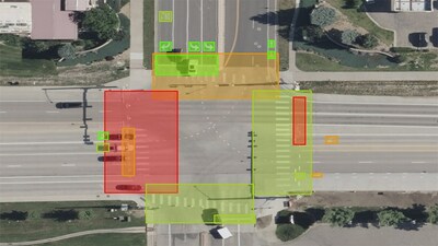
Roadways is the newest addition to Elements, a product suite of attributes extracted from Vexcel's aerial imagery and geospatial data using AI and machine learning (ML). "We've already been offering our partners and customers AI-derived attributes for more than 100 million properties and buildings in the
Automated Roadway Attributes Available with Frequent Updates
Roadways focuses on two types of non-highway road data: infrastructure and pavement markings. With infrastructure, key features are mapped and identified within the city such as curb mats, pedestrian islands, and roundabouts. With pavement markings, key features and condition ratings are provided for arrows, crosswalks, stop lines, symbols, and street text.
Vexcel's highly accurate aerial imagery is refreshed up to three times annually in the cities where Roadways data is processed, helping agencies update road data more frequently at a lower cost.
Sample datasets of Roadways information were provided to civil engineering firms, like DKS Associates, to evaluate and inventory roadway infrastructure.
"Maintaining up-to-date transportation system inventory data is challenging for many DOTs that use traditional field and desktop methods. For our statewide multimodal system inventory project in Oregon, we teamed with Vexcel to leverage their AI and machine learning advancements to deliver data, saving substantial time and money. Their ability to use ML to derive the data we need from high-resolution aerial imagery helps us to rapidly collect the road element data for motor vehicle, pedestrian, and bicycle systems in all 48 urban jurisdictions in the state," said
In addition, Roadways data helps agencies triage projects faster, identify problem areas, and get a holistic picture of what exists on roads. Named features in the dataset are also up to date with the latest
"Crosswalk and stop line markings, bike symbols and text, and well-maintained colored pavements are important elements of vulnerable road user (VRU) safety. Our organization is excited to work with Vexcel's high-res imagery and AI-derived VRU features to inventory and identify current condition and better predict product lifecycle and refresh schedules," said
Roadways datasets will be delivered with corresponding aerial imagery and optimized for use in common GIS and planning software. To learn more about Roadways, including a full list of attributes, visit vexceldata.com/roadways.
About Vexcel Data Program
For over 30 years, Vexcel has been the industry leader in the photogrammetric and remote sensing space, building market-leading UltraCam sensors, and providing a comprehensive library of cloud-based geospatial data. The Vexcel Data Program is the largest aerial imagery program in the world, collecting high-resolution imagery and geospatial data in 30+ countries. Its dedicated fleet of fixed-wing aircraft captures imagery in the
 View original content to download multimedia:https://www.prnewswire.com/news-releases/vexcel-launches-roadway-attributes-for-3-300-cities-across-us-302059055.html
SOURCE Vexcel Data Program
Serious News for Serious Traders! Try StreetInsider.com Premium Free!
You May Also Be Interested In
- Blokees Debuts 90+ New Products at Wonder Festival Shanghai 2026
- Plastic-Covered Couch Turned Work of Art To Protect Black Culture Lands In Brooklyn This Weekend
- Shiba Inu Price Prediction: Another 2021 Run? AlphaPepe Adds AI Trading to the Hunt for the Next Meme Breakout
Create E-mail Alert Related Categories
PRNewswire, Press ReleasesSign up for StreetInsider Free!
Receive full access to all new and archived articles, unlimited portfolio tracking, e-mail alerts, custom newswires and RSS feeds - and more!
