

Solis Minerals: Project Tenements Granted at Cinto
 Tweet
Tweet Share
ShareGet Alerts SLM Hot Sheet
Join SI Premium – FREE
- Seven tenements granted in the highly prospective southern Peruvian Copper belt, southeast of world class Toquepala Au/Ag/Cu/Mo Porphyry Mine.
- Solis' new Cinto Project straddles the regional scale Incapuquio Fault system, and is interpreted to be similar rocks that host Toquepala, 15km to the northwest.
- Worldview-3 remote sensing data and alteration interpretation being completed over key Solis' Peruvian projects - indentifying new drill targets at Ilo Este.
- Field check of highlighted anomalies and detailed geological mapping to commence immediately in preparation for drill testing.
Vancouver, British Columbia--(Newsfile Corp. - October 12, 2022) - Solis Minerals Ltd. (ASX: SLM) (TSXV: SLMN) (FSE: 08W) ("Solis Minerals" or "the Company") is excited to announce it has received confirmation of grants for a series of largely contiguous tenements totalling 3,200ha in the highly prospective southern Peruvian Copper belt, located some 15km to the southeast of the world class Toquepala Au/Ag/Cu/Mo Porphyry Mine (Figure 1 and Appendix 1). The new project will be called the Cinto Project.
The Company has completed the initial compilation of available geological and other data sets over the area, including the acquisition of new remote-sensing satellite data (comprising the Worldview-3[1] platform, amongst others) covering Cinto and Solis' other Peruvian copper projects. Specialist consultant interpretation of this new satellite data has highlighted several priority zones of favourable alteration - particularly at Ilo Este- which has never been tested. Field geological teams will mobilise shortly to undertake detailed field checking, mapping and systematic sampling of the highlighted alteration anomalies in preparation for drill testing. Detailed Worldview-3 data has been acquired over Cinto and is being processed.
CEO Jason Cubitt commented:
"This is an exciting development for Solis shareholders as the Cinto Project offers an opportunity to be the first exploration company to use modern exploration techniques on a staked area, located near one of Peru's largest copper producers, Toquepala mine[2]. With the same major structural controls, and similar rock type and age to Toquepala (57 Ma - 57 million years), we intend to advance this project to a drill-ready stage and offer Solis shareholders exposure to another world-class target in Peru's Southwest copper belt. The Company remains fully funded for this year's field season."
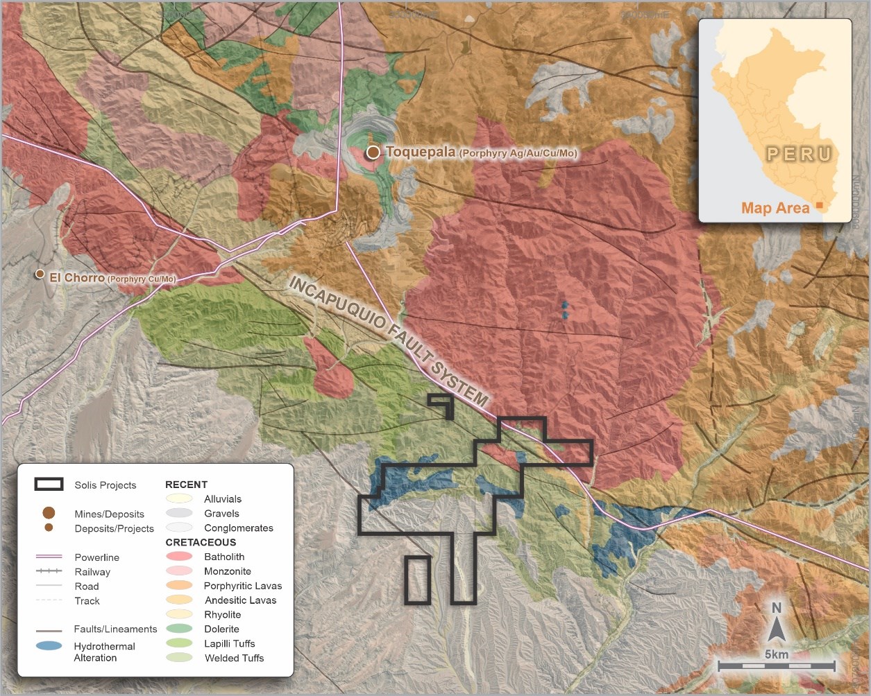
Figure 1: Cinto Project - Regional geology and Project location
To view an enhanced version of this graphic, please visit:
https://images.newsfilecorp.com/files/1134/140273_2c07ab0d1483ea0f_001full.jpg
Cinto Copper Project
The northern permits are underlain by igneous rocks of the Cretaceous Toquepala Group and the late Cretaceous-early Tertiary batholith related to the Toquepala porphyry mine some 15km to the northwest.
The regional Incapuquio fault crosses the permits and the underlying igneous rocks are covered by recent sediments, generally south of the fault and increasing in thickness to the southwest.
Several zones of hydrothermal alteration in the concessions are noted in published geological maps. The Company has recently acquired Worldview-3 satellite imagery to assist in rapid delineation of priority areas which will be followed up with geological mapping and rock sampling. The satellite data is currently being processed. Potential drill target identification would initiate permit applications for first-pass drill programs.
Ilo Este Copper Project
The Ilo Este (east) Project comprises four contiguous tenements covering an area of approximately 3,200ha (Figure 2). They are located about 110km northwest of the town of Tacna (Appendix 1).

Figure 2: Ilo Este Project - Tenure and Project location
To view an enhanced version of this graphic, please visit:
https://images.newsfilecorp.com/files/1134/140273_2c07ab0d1483ea0f_002full.jpg
Exploration undertaken by previous owners at Ilo Este included 12 reverse circulation (RC) drill holes (2000) and 12 diamond drill holes (2014-16), which were successful in identifying copper-gold mineralisation and interpreted to be part of a Cu-Au porphyry system. Mineralisation is differentiated into two types:
1) Oxide zone - green copper oxide minerals (brocanite, atacamite, malachite, neocite, hematite and manganese oxides) with carbonate staining that occurs across both the southern and northern intrusion belts and occurring to depths of approximately 80m.
2) Hypogene mineralisation - copper sulphides (chalcopyrite-bornite-pyrite) occur as disseminations, in fractures and within quartz veins that occur as a random stockwork within porphyritic granodiorite and porphyritic quartz diorite of the northern intrusive belt.
Although it is thought that the parts of llo Este porphyry system may have been deeply eroded down to the potassic zone, there remains the potential to discover higher grade mineralisation in areas of the porphyry that have been less eroded as well as a lower-grade orebody within the remnants of the porphyry. There is also potential for the intrusive belts to continue under cover to the south and east and to have been offset by a major fault (the Chololo Fault) striking to the northeast that could have offset the upper portion of the porphyry. This upper part could potentially host a higher grade phyllic zone of mineralisation.
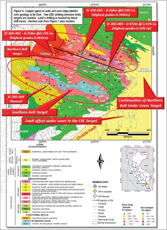
Figure 3: Map of the Ilo Este Copper Project showing geological mapping, geochemical surface sampling and drill hole collars and traces. (Source: Latin Resources Limited ASX release dated 3 February 2015; Copper Mineralisation Confirmed over 1.1km of Strike at Ilo Este Copper Porphyry)
To view an enhanced version of this graphic, please visit:
https://images.newsfilecorp.com/files/1134/140273_2c07ab0d1483ea0f_003full.jpg
The Company has recently undertaken Worldview-3 satellite imagery studies and is interpreting the data. Based on initial results indicating untested alteration, it is envisaged that further areas for exploration north of the Chololo fault (Figure 4) will be subject to geological ground mapping, rock sampling, and renewed alteration domain interpretation. South of the Chololo fault, in areas of recent geological cover, a ground magnetic geophysical survey will be undertaken in areas viewed to contain favourable underlying structural architecture to host porphyry-style intrusives. These programs, combined with data from previous drilling, will allow drill planning to proceed in the coming months and permitting to be initiated.

Figure 4: Ilo Este map of simplified geology: Blue - Jurassic intrusives/volcanics, Red - Cretaceous Batholith, Stippled - Tertiary cover, Green - Quaternary cover
To view an enhanced version of this graphic, please visit:
https://images.newsfilecorp.com/files/1134/140273_2c07ab0d1483ea0f_004full.jpg
Ilo Norte Copper Project
The Ilo Norte Project area (Figure 5) consists of eight Mining Concessions covering a total area of 7,700ha approximately 20km northeast from the Pacific coastal town of Ilo, in the Ilo Province, Department of Moquegua of Sothern Peru (Appendix 1).

Figure 5: Ilo Norte Project - Tenure and Project location
To view an enhanced version of this graphic, please visit:
https://images.newsfilecorp.com/files/1134/140273_2c07ab0d1483ea0f_005full.jpg
The geology of the llo Norte Project area consists of andesitic pyroclastics, andesitic volcanics belonging to the Chocolate Formation and younger Quaternary cover sediments (Figure 6 and Appendix 1).
Exploration undertaken by previous owners at Ilo Norte included eight RC holes (2011) and 16 diamond holes (2014). Mineralisation encountered at llo Norte is interpreted to be part of an IOCG-type deposit contained within the highly altered andesitic volcaniclastics of the Chocolate Formation. Contact metamorphism and metasomatism have produced at least five phases of widespread development of mostly lentiform economic mineral assemblages including copper, gold, silver, zinc and minor cobalt.

Figure 6: Ilo Norte Project (western part) -Project geology and historical drill collar locations: (Source: NI43-101 Technical Report: Ilo Norte and Ilo Este projects, Griffin 2017). Notes: Orange hashed area indicates potential skarn alteration zone. Red stippled area represents silica-albite alteration
To view an enhanced version of this graphic, please visit:
https://images.newsfilecorp.com/files/1134/140273_2c07ab0d1483ea0f_006full.jpg
The Company is planning to acquire Worldview-3 satellite data at Ilo Norte in the coming months when climatic conditions are more favourable. This will augment the planning of the exploration programs which will be principally based around extending ground magnetics surveys over cover, and IP surveys where geological and access condition allow in the west of the area. This data, combined with previous drill results and structural interpretation, is expected to assist planning of future drilling.
Proposed Work Program
Cinto: Process Worldview-3 data, identify zones of interest. Mapping, prospecting leading to identification of potential drill targets. Initiate drill permitting leading to potential drill programs.
Ilo Este: Follow-up field visits to newly identified alteration areas. Mapping and prospecting leading to identification of potential drill targets (0-3 months). Follow-up south of regional fault with ground mag survey for additional targets. Initiate drill permitting leading to potential drill programs in 2023.
Ilo Norte: Acquire Worldview-3 satellite imagery (0-3 months). Follow-up with field visits. Complete IP and ground mag surveys where practical. Initiate drill permitting leading to potential drill programs in 2023.
About Solis Minerals Ltd.
Solis Minerals is a Latin American battery mineral-focused mining exploration company. The Company holds a 100% interest in a package of highly prospective IOCG (iron oxide copper/gold) and porphyry copper projects in southwestern Peru within the country's prolific coastal copper belt - a source of nearly half of Peru's copper production.
Issued on the directive of the Solis board.
For further information please contact:
Jason Cubitt
President and CEO
Solis Minerals Ltd.
+1 (604) 209 1658
Stephen Moloney
Investor Relations
Corporate Storytime
+61 (0)403 222 052
Neither the TSX Venture Exchange nor its Regulation Service Provider (as the term is defined in the policies of the TSX Venture Exchange) accepts responsibility for the adequacy of accuracy of this news release.
Forward-Looking Statements
This news release contains certain forward-looking statements, which relate to future events or future performance and reflect management's current expectations and assumptions. Such forward-looking statements reflect management's current beliefs and are based on assumptions made by and information currently available to the Company. Readers are cautioned that these forward-looking statements are neither promises nor guarantees, and are subject to risks and uncertainties that may cause future results to differ materially from those expected including, but not limited to, market conditions, availability of financing, actual results of the Company's exploration and other activities, environmental risks, future metal prices, operating risks, accidents, labour issues, delays in obtaining governmental approvals and permits, and other risks in the mining industry. All the forward-looking statements made in this news release are qualified by these cautionary statements and those in our continuous disclosure filings available on SEDAR at www.sedar.com. These forward-looking statements are made as of the date hereof and the Company does not assume any obligation to update or revise them to reflect new events or circumstances save as required by applicable law.
Qualified Person Statement
The technical information in this news release was reviewed by Fred Tejada, P.Geo, a qualified person as defined by National Instrument 43-101 (NI 43-101).
Competent Person Statement
The information in this ASX release in relation to Geological Information and Exploration Results is based on and fairly represent information compiled by Mr Anthony Greenaway, a Competent Person who is a Member of the Australasian Institute of Mining and Metallurgy. Mr Greenaway is an employee of Solis Minerals Ltd. and has sufficient experience which is relevant to the style of mineralisation and types of deposit under consideration and to the exploration activities undertaken to qualify as a Competent Person as defined in the 2012 Edition of the "Australian Code for Reporting of Mineral Resources and Ore Reserves". Mr Greenaway consents to the inclusion in this report of the matters based on information in the form and context in which it appears. Mr Greenaway has provided his prior written consent as to the form and context in which the Geological Information and Exploration Results and supporting information are presented in this Announcement.
All information relating to exploration results that have been previously released to the market is appropriately referenced in this document.
APPENDIX 1
Solis Minerals Limited Peruvian Project Location Map.

To view an enhanced version of this graphic, please visit:
https://images.newsfilecorp.com/files/1134/140273_2c07ab0d1483ea0f_007full.jpg
APPENDIX 2
JORC Code, 2012 Edition - Table 1
Section 1 Sampling Techniques and Data
(Criteria in this section apply to all succeeding sections)
| Criteria | JORC Code explanation | Commentary |
| Sampling techniques |
|
|
| Drilling techniques |
|
|
| Drill sample recovery |
|
|
| Logging |
|
|
| Sub-sampling techniques and sample preparation |
|
|
Serious News for Serious Traders! Try StreetInsider.com Premium Free!
You May Also Be Interested In
- Patrick and LCI Industries to merge in all-stock deal
- Northern Graphite Completes Processing Plant Relocation to Advance Okanjande Mine Restart
- Metalsource Mining Continues to Define High Grade Polymetallic Core at Silver Hill with 33 Metre down Plunge Step Out
Create E-mail Alert Related Categories
Newsfile, Press ReleasesRelated Entities
Definitive AgreementSign up for StreetInsider Free!
Receive full access to all new and archived articles, unlimited portfolio tracking, e-mail alerts, custom newswires and RSS feeds - and more!