Form 8-K Bunker Hill Mining Corp. For: May 04
 Tweet
Tweet Share
Share
UNITED STATES
SECURITIES AND EXCHANGE COMMISSION
Washington, D.C. 20549
FORM 8-K
CURRENT REPORT
Pursuant to Section 13 or 15(d) of the Securities Exchange Act of 1934
Date of Report (Date of earliest event reported) May 4, 2021
BUNKER HILL MINING CORP.
(Exact name of registrant as specified in its charter)
| Nevada | 333-249682 | 32-0196442 | ||
(State or other jurisdiction of incorporation) |
(Commission File Number) |
(IRS Employer Identification No.) |
| 82 Richmond Street East, Toronto, Ontario, Canada | M5C 1P1 | |
| (Address of principal executive offices) | (Zip Code) |
Registrant’s telephone number, including area code 416-477-7771
Check the appropriate box below if the Form 8-K filing is intended to simultaneously satisfy the filing obligation of the registrant under any of the following provisions (see General Instruction A.2.below):
| [ ] | Written communications pursuant to Rule 425 under the Securities Act (17 CFR 230.425) |
| [ ] | Soliciting material pursuant to Rule 14a-12 under the Exchange Act (17 CFR 240.14a-12) |
| [ ] | Pre-commencement communications pursuant to Rule 14d-2(b) under the Exchange Act (17 CFR 240.14d-2(b)) |
| [ ] | Pre-commencement communications pursuant to Rule 13e-4(c) under the Exchange Act (17 CFR 240.13e-4(c)) |
Securities registered pursuant to Section 12(b) of the Act:
| Title of Each Class | Trading Symbol | Name of each Exchange on which Registered | ||
| None |
Item 8.01 Other Events.
On May 3, 2021, Bunker Hill Mining Corp. filed a technical report entitled “Technical Report for the Bunker Hill Mine, Coeur d’Alene Mining District, Shoshone County, Idaho, USA” with an effective date of March 22, 2021.
ITEM 9.01(b) Exhibits
| Exhibit | Description | |
| 99 | Technical Report for the Bunker Hill Mine, Coeur d’Alene Mining District, Shoshone County, Idaho, USA |
SIGNATURES
Pursuant to the requirements of the Securities Exchange Act of 1934, the registrant has duly caused this report to be signed on its behalf by the undersigned hereunto duly authorized.
| BUNKER HILL MINING CORP. | ||
| Date: May 4, 2021 | By: | /s/ Sam Ash |
| Sam Ash | ||
| CEO | ||
Exhibit 99
Technical Report
for the
Bunker Hill Mine
Coeur d’Alene Mining District
Shoshone County, Idaho, USA
Effective Date: March 22, 2021
PREPARED FOR:
Bunker Hill Mining Corp.
by
Resource Development Associates Inc.
Qualified Person
Scott E. Wilson, C.P.G., SME
Highlands Ranch, CO 80126
303-717-3672
Date and Signature Page
Bunker Hill Mining Corp.: Technical Report for the Bunker Hill Mine, Coeur d’Alene Mining District, Shoshone County, Idaho, USA.
Technical Report Effective Date: March 22, 2021
Dated this 3rd day of May, 2021
| (signed/sealed) Scott E. Wilson | |
| Scott E. Wilson, SME-RM, CPG | |
| Geologist |
Author Certificate
Scott E. Wilson
I, Scott E. Wilson, CPG, SME-RM, of Highlands Ranch, Colorado, as the author of the technical report entitled “Technical Report for the Bunker Hill Mine, Coeur d’Alene Mining District, Shoshone County, Idaho, USA” (the “Technical Report”) with an effective date of March 22, 2020 prepared for Bunker Hill Mining Corp. (the “Issuer”), do hereby certify:
| 1. | I am currently employed as President by Resource Development Associates, Inc., 10262 Willowbridge Way, Highlands Ranch, Colorado USA 80126. | |
| 2. | I graduated with a Bachelor of Arts degree in Geology from the California State University, Sacramento in 1989. | |
| 3. | I am a Certified Professional Geologist and member of the American Institute of Professional Geologists (CPG #10965) and a Registered Member (#4025107) of the Society for Mining, Metallurgy and Exploration, Inc. | |
| 4. | I have been employed as both a geologist and a mining engineer continuously for a total of 31 years. My experience included resource estimation, mine planning, geological modeling, geostatistical evaluations, project development, and authorship of numerous technical reports and preliminary economic assessments of various projects throughout North America, South America and Europe. I have employed and mentored mining engineers and geologists continuously since 2003. | |
| 5. | I have read the definition of “Qualified Person” set out in National Instrument 43-101 (“NI 43-101) and certify that by reason of my education, affiliation with a professional association (as defined in NI 43-101) and past relevant work experience, I fulfill the requirements to be a “Qualified Person” for the purposes of NI 43-101. | |
| 6. | I have made several personal inspections of the Bunker Hill Project with the most recent visit January 11-13, 2021. | |
| 7. | I am responsible for Sections 1 through 26 of the Technical Report. | |
| 8. | I am independent of the Issuer as independence is described in Section 1.5 of NI 43-101. | |
| 9. | Prior to being retained by the Issuer, I have not had prior involvement with the property that is the subject of the Technical Report. | |
| 10. | I have read NI 43-101 and Form 43-101F1, and this Technical Report was prepared in compliance with NI 43-101. | |
| 11. | As of the effective date of this Technical Report, to the best of my knowledge, information and belief, the portions of the Technical Report for which I am responsible contain all scientific and technical information that is required to be disclosed to make the portions of the Technical Report for which I am responsible not misleading. |
| Dated: May 3, 2021 | |
| (signed/sealed) Scott Wilson | |
| Scott E. Wilson, CPG, SME-RM |
Table of Contents
| 1 | Summary | 7 |
| 2 | Introduction | 10 |
| 3 | Reliance on Other Experts | 11 |
| 4 | Property Description and Location | 12 |
| 5 | Accessibility, Climate, Local Resources, Infrastructure and Physiography | 62 |
| 6 | History | 63 |
| 7 | Geological Setting and Mineralization | 68 |
| 8 | Deposit Types | 85 |
| 9 | Exploration | 86 |
| 10 | Drilling | 89 |
| 11 | Sample Preparation, Analysis and Security | 98 |
| 12 | Data Verification | 106 |
| 13 | Mineral Processing and Metallurgical Testing | 112 |
| 14 | Mineral Resource Estimates | 113 |
| 15 | Mineral Reserves | 126 |
| 16 | Mining Methods | 127 |
| 17 | Recovery Methods | 128 |
| 18 | Project Infrastructure | 129 |
| 19 | MArket Studies and COntracts | 130 |
| 20 | EnvirOnmental Studies, PErmitting and Social or Community IMpact | 131 |
| 21 | Capital and Operating COsts | 132 |
| 22 | Economic Anlysis | 133 |
| 23 | Adjacent Properties | 134 |
| 24 | Other Relevant Data and Information | 135 |
| 25 | Interpretations and Conclusions | 136 |
| 26 | Recommendations | 137 |
| 27 | References | 138 |
Tables
| Table 1-1 | Bunker Hill Indicated Mineral Resource Estimate– Mineralization Underground Accessible – Economic at Metal Selling Prices of $23 Per Ounce Ag, $1.00 Per Pound Zinc and $0.80 Per Pound Lead. Resources Estimated at a 3.30% Zinc Cutoff Grade. (Qualified Person: RDA, Scott Wilson, CPG; Effective March 22, 2021) | 7 | |
| Table 1-2 | Proposed Budget for Project Advancement | 9 | |
| Table 4-1 | Tax Parcels and Mineral Interests Included in the Lease | 14 | |
| Table 4-2 | Patented Mining Claims Included Under Mineral Guarantee | 15 | |
| Table 6-1 | Mine Production by Zone | 65 | |
| Table 12-1 | Chanel Sample Breakdown | 111 | |
| Table 14-1 | Bunker Hill Mine Indicated Mineral Resources at Zinc Selling Price of USD $1.00 per Pound, Pb Selling Price of $0.80 Per Pound and Silver Selling Price of $23 Per Ounce (Effective date March 22, 2021) | 113 | |
| Table 14-2 | Bunker Hill Mine Inferred Mineral Resources at Zinc Selling Price of USD $1.00 per Pound, Pb Selling Price of $0.80 Per Pound and Silver Selling Price of $23 Per Ounce (Effective date March 22, 2021) | 114 | |
| Table 14-3 | Bunker Hill Mine Inferred PbAg Mineral Resource (Effective Date March 22, 2021) | 124 | |
| Table 14-4 | Bunker Hill Mine Inferred ZnAg Mineral Resource (Effective Date March22, 2021) | 125 | |
| Table 14-5 | Bunker Hill Mine Indicated ZnAg Mineral Resource (Effective Date March22, 2021) | 125 | |
| Table 23-1 | Crescent Silver Project Mineral Resource | 135 | |
| Table 23-2 | Sunshine Mine Mineral Resource Estimate | 135 | |
| Table 26-1 | Proposed Phase 1 Work Program to Advance Bunker Hill | 137 |
Figures
| Figure 4-1 | Property Map of Bunker Hill Mine Patented Mining Claims | 12 | |
| Figure 7-1 | Stratigraphic section of Belt-Purcell Supergroup across northern Idaho and western Montana. Mineral deposits noted in red at stratigraphic position of host rocks (from Lyndon, 2007). | 68 | |
| Figure 7-2 | Geologic map of Shoshone County, clipped and centered on Coeur d’Alene Mining District, Bunker Hill Mine highlighted in red (IGS 2002). | 69 | |
| Figure 7-3- (1 of 2) | Diagrammatic sequence of large-scale events in the structural history of CDA District rocks | 71 | |
| Figure 7-4 (2 of 2) | Diagrammatic sequence of large-scale events in the structural history of CDA District rocks | 72 | |
| Figure 7-5 | Surface geology over Bunker Hill Mine. Cross-Section A-A’ shown below in Fig. X10. (White and Juras 1976) | 73 | |
| Figure 7-6 | Stratigraphic section of Revett formation in Bunker Hill area (White, 1976) | 75 | |
| Figure 7-7 | Geologic Map of Bunker Hill Mine 17 Level showing quartzite units and exploration drill holes | 76 | |
| Figure 7-8 | Isometric view of Vulcan 3D model of L-0 through U-5 Quartzite units, looking nearly down-plunge on the Tyler Ridge Flexure axial plane, shown as red lines offset by faults. Note post-fold offsets of stratigraphy along numerous faults, only Cate Fault i | 77 | |
| Figure 7-9 | Diagram of structural preparation of a quartzite bed from folding stresses (Juras and Duff, 2020) | 78 | |
| Figure 7-10 | Cross-section A-A’ looking W-NW, not to scale, from surface geology map Fig. X5 (White and Juras 1976). Darker orange is quartzite bed in Upper Revett Formation, legend on Fig. X5 | 79 | |
| Figure 7-11 | Bunker Hill Mine workings with 3D vein models showing difference between Bluebird and Galena-Quartz Vein systems and location of hybrid mineralized zones. | 81 | |
| Figure 7-12 | Plan view and cross-sectional diagram of formation of mineralized shoot along vein in quartzite unit where rheologic contrast between argillite and quartzite causes refraction of vein surface (Juras, 1977) | 83 | |
| Figure 9-1 | 1500 ft thick cross-section along BH #2 Shaft, looking at 106 azm, -12 degrees. Mine levels and shafts are black lines, thin dark orange shape between levels on left is 3D model of U-1 quartzite unit of Revett formation, thick orange shape is M-3 siltite-argillite unit. Shapes built directly from original field mapping. | 86 | |
| Figure 9-2 | Isometric view of plan section through 3D lithology and Fault Models at BH 9 Level. View is looking 311 azm, -21 dip, with 100’ window on either side of stratigraphy map at 2405’ elevation. | 87 | |
| Figure 9-3 | Cross-section through Vulcan 3D models along planned drill hole trace showing expected downhole depths of projected geologic features. Historic Sierra Nevada Mine levels in black center right. | 88 | |
| Figure 12-1 | Rib sample collected from the 082-25-80 sublevel | 108 | |
| Figure 12-2 | Back Sample collected from the 082-25-80 sublevel | 108 | |
| Figure 12-3 | Sample locations on the 070-25-07 sublevel using geo-referenced AutoCAD files | 108 | |
| Figure 12-4 | Sample locations on the 082-25-80 sublevel using geo-referenced AutoCAD files | 109 | |
| Figure 12-5 | Sample locations on the 084-25-72 sublevel using geo-referenced AutoCAD files | 110 | |
| Figure 14-1 | Quill, Newgard and UTZ deposits of the Bunker Hill Mine. Mineral resources between levels and within pillars have been updated for this report. | 115 | |
| Figure 14-2 | Vertical long section through the deposit showing currently mined out stopes down-dip and mineralized pillars between stopes. | 116 | |
| Figure 14-3. | Interpretation of mineral envelope based on drilling, mining, and sampling of the deposit. | 117 | |
| Figure 14-4. | Long Section through Drilling used to Support the Mineral Estimate. | 118 | |
| Figure 14-5. | Oblique view through Drilled Mineralization for the Updated Estimate. | 119 | |
| Figure 14-6 | Channel Sampling and Production Car Sampling use to Support the Mineral Estimate. | 120 | |
| Figure 14-7. | Channel Samples, Production Car Samples and Drilling Composites used for the Mineral Resource Estimate | 121 | |
| Figure 14-8 | Estimated Mineralization at the Zn Cutoff grade of 3.3% | 122 | |
| Figure 14-9 | Classified Mineralization for UTZ, Quill and Newgard Deposits | 123 | |
| Figure 14-10 | Cell Declustering used for Zinc and Lead Estimates | 124 |
| Bunker Hill Mining Corp. | |
| Technical Report March 22, 2021 | Page 7 |
1 Summary
This technical report entitled “Technical Report for the Bunker Hill Mine, Coeur d’Alene Mining District, Shoshone County, Idaho, USA” written by Scott E. Wilson, CPG, SME-RM (the “Author”) with an effective date of March 22, 2021 and dated May 3, 2021 (the “Technical Report”) summarizes technical information gathered on the Bunker Hill property (“Bunker” or “Bunker Hill” or “Project” or “Property” or “Bunker Hill Property”) for Bunker Hill Mining Corp. (“BNKR” or the “Company”).
BNKR retained the services of Scott Wilson of Resource Development Associates Inc. (“RDA”) to recommend work programs that would allow the Company to publicly disclose Mineral Resource Estimates for the Bunker Hill mine (the “Bunker Hill Mine” or “Mine”). BNKR first reported Inferred Mineral Resource estimates for the Project on September 29, 2020. These estimates were based on historic reserve estimates which were done historically with a high degree of professionalism and with methodologies that were considered accurate and acceptable within proper engineering principles of the time. RDA concluded that some portion of the mineral resource estimate may be converted to Indicated Mineralization by employing modern resource estimation practices and three-dimensional modelling techniques. RDA completed a grade estimation program for the Newgard and Quill mineral deposits. Additionally, a new inferred and indicated mineral resource has been estimated for the UTZ mineral body which is located near the town of Wardner Idaho.
1.1 Resource Estimates
Table 1-1 Bunker Hill Indicated Mineral Resource Estimate– Mineralization Underground Accessible – Economic at Metal Selling Prices of $23 Per Ounce Ag, $1.00 Per Pound Zinc and $0.80 Per Pound Lead. Resources Estimated at a 3.30% Zinc Cutoff Grade. (Qualified Person: RDA, Scott Wilson, CPG; Effective March 22, 2021)
| Indicated Mineral Resources | Tonnes (x1,000) | Pb % | Pb Lbs. (x1,000) | Ag Oz/Ton | Ag Ounces (x1,000) | Zn % | Zn Lbs. (x1,000) | |||||||||||||||||||||
| ZnAg Indicated Mineral Resources | 4,410 | 2.00 | 176,771 | 0.69 | 3,033 | 5.52 | 487,185 | |||||||||||||||||||||
| Inferred Mineral Resources | Tonnes (x1,000) | Pb % | Pb Lbs. (x1,000) | Ag Oz/Ton | Ag Ounces (x1,000) | Zn % | Zn Lbs. (x1,000) | |||||||||||||||||||||
| PbAg Inferred Mineral Resources | 1,050 | 7.56 | 158,815 | 4.28 | 4,497 | 1.50 | 31,419 | |||||||||||||||||||||
| ZnAg Inferred Mineral Resources | 4,569 | 1.67 | 152,878 | 0.83 | 3,796 | 5.66 | 517,403 | |||||||||||||||||||||
| Bunker Hill Total Inferred Mineral Resources | 5,618 | 2.77 | 311,693 | 1.48 | 8,294 | 4.88 | 548,821 | |||||||||||||||||||||
Mineral Resources are not Mineral Reserves and do not have demonstrated economic viability. There is no certainty that all or any part of the Mineral Resources will be converted into Mineral Reserves. Numbers may not add up due to rounding.
1.2 Property Descriptions and Ownership
Bunker Hill Mine is located in the cities of Kellogg and Wardner of Shoshone County, Idaho. The mine is currently owned by Placer Mining Corporation (“PMC”). On August 17, 2017, BNKR and PMC, entered into a two-year Mining Lease with Option to Purchase (together, the “Lease”). The Lease became effective on November 1, 2017. The lease provides that BNKR will operate the Bunker Hill Mine and make certain improvements on the Mine along with making monthly $60,000 payments to PMC over the term of the lease.
On November 1, 2019, BNKR and the current owner signed an amendment to its Lease for the Bunker Hill Mine. Under the new amended agreement, the lease period has been extended for an additional period of nine months through August 1, 2020.
On July 27, 2020, this Lease was further extended until August 1, 2022.
On November 20, 2020, the parties amended the Lease. Under the amended terms, the purchase price was decreased to $7,700,000, with $5,700,000 payable in cash (with an aggregate of $300,000 to be credited toward the purchase price of the Mine as having been previously paid by BNKR and an aggregate of $5,400,000 payable in cash outstanding) and $2,000,000 in common shares of BNKR. Further, under the amendment to the Lease, BNKR was to make an advance payment of $2,000,000 to PMC, which shall be credited toward the purchase price of the Mine when BNKR elects to exercise its purchase right. BNKR made this advance payment, which had the effect of decreasing the remaining amount payable to purchase the Mine to an aggregate of $3,400,000 payable in cash and $2,000,000 in common shares of BNKR.
Pursuant to the Lease, BNKR has the exclusive right to purchase the Bunker Hill Mine during the lease term upon notice to PMC and the United States (“U.S.”).
| Bunker Hill Mining Corp. | |
| Technical Report March 22, 2021 | Page 8 |
1.3 Geology and Mineralization
The Northern Idaho Panhandle Region in which the Bunker Hill Property is located is underlain by the Middle Proterozoic-aged Belt-Purcell Supergroup of fine-grained, dominantly siliciclastic sedimentary rocks which extends from western Montana (locally named the Belt Supergroup) to southern British Columbia (Locally named the Purcell Supergroup) and is collectively over 23,000 feet in total stratigraphic thickness.
Mineralization at the Bunker Hill Mine is hosted almost exclusively in the Upper Revett formation of the Ravalli Group, a part of the Belt Supergroup of Middle Proterozoic-aged, fine grained sediments. Geologic mapping and interpretation progressed by leaps and bounds following the recognition of a predictable stratigraphic section at the Bunker Hill Mine, and enabled the measurement of specific offsets across major faults, discussed in the following section. From an exploration and mining perspective, there were two critical conclusions from this research: all significant mineralized shoots are hosted in quartzite units where they are cut by vein structures, and the location of the quartzite units can be projected up and down section, and across fault offsets, to targets extensions and offsets of known mineralized shoots and veins.
Mineralization at Bunker Hill falls in four categories, described below from oldest to youngest events:
Bluebird Veins (BB): W—NW striking, SW-dipping (Fig. 7-11), variable ratio of sphalerite-pyrite-siderite mineralization. Thick, tabular cores with gradational margins bleeding out along bedding and fractures. Detailed description in Section 7.2.2.
Stringer/Disseminated Zones: Disseminated, fracture controlled and bedding controlled blebs and stringer mineralization associated with Bluebird Structures, commonly as halos to vein-like bodies or as isolated areas where brecciated quartzite beds are intersected by the W-NW structure and fold fabrics.
Galena-Quartz Veins (GQ): E to NE striking, S to SE dipping (Fig. 7-11), quartz-argentiferous galena +/- siderite-sphalerite-chalcopyrite-tertahedrite veins, sinuous-planar with sharp margins, cross-cut Bluebird Veins. Detailed description in Section 7.2.2.
Hybrid Zones: Formed at intersections where GQ veins cut BB veins (Fig. 7-11), with open space deposition of sulfides and quartz in the vein refraction in quartzite beds, and replacement of siderite in the BB vein structure by argentiferous galena from the GQ Vein.
1.4 Current Exploration and Development
BNKR has a rare exploration opportunity available at the Mine and has embarked on a new path to fully maximize the potential. A treasure trove of geologic and production data has been organized and preserved in good condition in the mine office since the shutdown of major mine operations in the early 1980s. This data represents 70+ years of proper scientific data and sample collection, with high standards of accuracy and precision that were generally at or above industry standards at the time.
The Company saw the wealth of information that was available, but not readily usable, and embarked on a scanning and digitizing program. From this they were able to build a 3D digital model of the mine workings and 3D surfaces and solids of important geologic features. To add to this, all of the historic drill core lithology logs and assay data (>2900 holes) was entered into a database and imported with the other data into Maptek Vulcan 3D software.
Exploration drilling at the Property is focused on the confirmation of silver rich mineralization and wide intercepts of bluebird veins near the Homestake tunnel.
| Bunker Hill Mining Corp. | |
| Technical Report March 22, 2021 | Page 9 |
1.5 Conclusions
BNKR continues investment in the advancement of the Project through drilling, tunnel refurbishment, technical evaluations, internally and with the assistance of reputable consulting firms. RDA is of the opinion that the current Mineral Resources at Bunker Hill are sufficient to warrant continued planning and effort to explore, permit and develop the Project, and that it supports the conclusions herein.
RDA is of the opinion that with a historic silver production of over 160 million ounces, silver mineralization should be investigated with vigorous exploration programs. While base metals are a very important component of the Project and drilling resources are recommended to be allocated to the further delineation and addition of base metal dominant resource, the recent selling price of silver demands attention. The confirmation drilling program identified intercepts of 10 to 20 ounces per ton of sliver. The J vein and Francis stopes hosted high grade silver mineralization and the near-surface historic Caledonia and Sierra Nevada Mines were bonanza grade silver producers in the past. These and other known occurrences of silver must be followed up upon to determine that economic silver occurrences exist on the Bunker Hill Property land package.
1.6 Recommendations
Exploration resources should be aimed at both continued addition and development of base metal resource material as well as silver-dominant resource expansion. Silver resources that have the reasonable prospects of eventual economic extraction have been identified within the current mineral resource estimate. Significant silver mineralization encountered through exploration and past production suggests that these zones should be given as much weight as past Pb and Zn exploration and resource definition programs.
There is sparse information available on the metallurgical characteristic of mineralization at the project. Obviously, historic production from two smelters suggests that metallurgy was understood or even assumed. Modern projects must understand metallurgy in order to begin the process of economic evaluations for the project. Metallurgical samples need to be collected for bluebird mineralization and quartz-galena mineralization as a starting point.
Digitization of nearly 100 years of paper maps is in progress and should be completed. In addition to unlocking the understanding of the geometry of the mineral deposit much of the information describes the mined-out portion of the Project. This will be critical for future mineral resource estimates as mined out voids need to be accounted for.
The projected costs for the continuing phase of this program are outlined in Table 1-2 and remain the focus as recommended in September 2020.
Table 1-2 Proposed Budget for Project Advancement
| Activity | Amount | |||
| Drilling Program focusing on Silver (includes labor and assaying) | $ | 2.10M | ||
| Metallurgical definition characteristics of Bluebird and Quartz-Galena Mineralization | $ | 0.20M | ||
| Digital compilation of historical information | $ | 0.75M | ||
| Environmental Studies as part of care and maintenance | $ | 0.80M | ||
| Rehabilitation and Infrastructure Improvements in Support of Drilling | $ | 1.30M | ||
| Total | $ | 5.15M | ||
| Bunker Hill Mining Corp. | |
| Technical Report March 22, 2021 | Page 10 |
2 Introduction
2.1 Terms of Reference
BNKR retained RDA to complete an independent NI 43-101 Technical Report for Bunker Hill Property located in the Coeur D’Alene Mining District, Shoshone County, Idaho. BNKR has acquired rights to title and to purchase the Property from its current owners, PMC.
The Bunker Hill Mine is a well-developed underground mining operation that ceased production in 1991. At cessation of mining, the Project contained mineralization that had been developed but not exploited. BNKR is implementing a plan to bring the brownfields Project back into production as a competitive mining operation in the Coeur d’Alene Mining District. No modern exploration has taken place on the Property since 1991.
The Project is located adjacent and directly south of the town of Kellogg Idaho. Mineralization at the Project is related to a large deposit of anomalous Lead, Zinc and Silver mineralization. Silver, lead and zinc were discovered at the Project in 1885. Production records kept annually from 1887 through 1991 show that the mine produced 35.78 million tons of mineralized material with head grades averaging grades of 4.52 opt Ag, 8.76% Pb and 3.67% Zn, containing 161.72 million ounces of Ag, 3.13 million tons of Pb and 1.31 million tons of Zn.
The Author has worked closely with the Company to follow the CIM Estimation of Mineral Resources and Mineral Reserves Best Practice Guidelines, November 29, 2019 and the CIM Mineral Exploration Best Practice Guidelines, November 23, 2018 with respect to the implementation and execution of the collection of scientific data for the Property.
This Technical Report was prepared by RDA, at the request of Mr. Sam Ash, President and CEO of BNKR, a public company trading on the Canadian Securities Exchange (CSE: BNKR) with its corporate office at 82 Richmond Street East, Toronto, Ontario M5C 1P1.
Mr. Scott E. Wilson, (CPG #10965, SME 4025107RM), an independent qualified person under the terms of NI 43-101, has conducted several site visits of the Property with the most recent visit January 11-13, 2021. The most recent site visit was to review the progress on the RDA recommended drilling and channel sampling program. These drilling and sampling campaigns were required by RDA in order to estimate Mineral Resources for the Project.
All dollar amounts in this document are United States dollars unless otherwise noted.
2.2 Sources of Information
This Technical Report is based, in part, on internal company technical reports, and maps, published government reports, company letters, memoranda, public disclosure and public information as listed in the References at the conclusion of this Technical Report. This Technical Report is supplemented by published and available reports provided by the United States Geological Survey (“USGS”), the Idaho Geological Survey, United States Bureau of Land Management and the United States Public Land Survey.
| Bunker Hill Mining Corp. | |
| Technical Report March 22, 2021 | Page 11 |
3 Reliance on Other Experts
With respect to land issues leases and information, the Author of this Technical Report has relied upon the Title Opinion of Lyons O’Dowd Law Firm dated August 12, 2020 as well as written and verbal communication with BNKR in the preparation of Section 4.
No other experts were relied upon in the preparation of this Technical Report.
| Bunker Hill Mining Corp. | |
| Technical Report March 22, 2021 | Page 12 |
4 Property Description and Location
Bunker Hill Mine is located in the cities of Kellogg and Wardner of Shoshone County, Idaho. The Kellogg Tunnel which is the main access to the mine is located at 47.53611°N latitude, 116.1381W longitude. The Mine is currently owned by PMC. On August 17, 2017, BNKR and PMC, entered into a two-year Lease. The Lease became effective on November 1, 2017. The lease provides that BNKR will operate the Bunker Hill Mine and make certain improvements on the Mine along with making monthly $60,000 payments to PMC over the term of the lease.
On November 1, 2019, BNKR and the current owner signed an amendment to its Lease for the Bunker Hill Mine. Under the new amended agreement, the lease period has been extended for an additional period of nine months through August 1, 2020.
On July 27, 2020, this Lease was further extended until August 1, 2022.
On November 20, 2020, the parties amended the Lease. Under the amended terms, the purchase price was decreased to $7,700,000, with $5,700,000 payable in cash (with an aggregate of $300,000 to be credited toward the purchase price of the Mine as having been previously paid by BNKR and an aggregate of $5,400,000 payable in cash outstanding) and $2,000,000 in common shares of BNKR. The reference price for the payment in common shares will be based on the share price of the last equity raise before the option is exercised. Further, under the amendment to the Lease, BNKR was to make an advance payment of $2,000,000 to PMC, which shall be credited toward the purchase price of the Mine when BNKR elects to exercise its purchase right. BNKR made this advance payment, which had the effect of decreasing the remaining amount payable to purchase the Mine to an aggregate of $3,400,000 payable in cash and $2,000,000 in common shares of BNKR.
In August 2020, this Lease was extended until August 1, 2022. Pursuant to the Lease, BNKR has the exclusive right to purchase the Bunker Hill Mine during the lease term upon notice to PMC and the United States. On October 14, 2020 PMC confirmed in writing that BNKR has made all monthly $60,000 payments due under this lease to date.
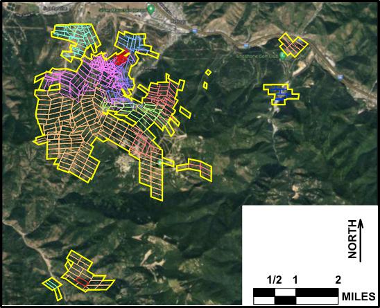
Figure 4-1 Property Map of Bunker Hill Mine Patented Mining Claims
| Bunker Hill Mining Corp. | |
| Technical Report March 22, 2021 | Page 13 |
4.1 Bunker Hill History
From its early days in the 1890s and through two World Wars, the Bunker Hill Company (“BMC”) operated as an independent and well-known mining and smelting company. BMC was listed on the New York Stock Exchange. On June 1, 1968, Bunker Hill became a wholly owned subsidiary of Gulf Resources & Chemical Corp.
Growing public concern with the environment in the 1970s compelled Bunker Hill to spend large sums on plant improvements in order to comply with newly enacted federal air and water pollution laws. The Company also made major efforts to reclaim surrounding hillsides which had been impacted by the effects of decades of airborne smelter effluents and timbering for mining purposes.
Ultimately the combination of high costs of environmental compliance and declines in metal prices in the early 1980s led to the decision by Gulf Resources in August 1981 to cease operations at Bunker Hill and to sell the mine. In 1982, the company was sold to the Bunker Limited Partnership (“BLP”). The principal owners of BLP were Harry Magnuson, Duane Hagadone, Jack Kendrick and Simplot Development Corporation. Simplot Development Corporation sold its share of the partnership in 1987.
The mine was reopened from 1988 to 1990 by BLP during which time exploration, resource definition, mine development and small-scale production occurred. A decline in metals prices in the early 1990s led BLP to close the mine in January of 1991. Shortly thereafter BLP filed for bankruptcy.
On May 1, 1992, the Bunker Hill Mine was sold to PMC. The sale related to Bunker Hill Mine only. Pintlar, Inc., a subsidiary of Gulf Resources & Chemical Corporation, remained responsible for the environmental cleanup of the portion of the Bunker Hill Superfund Site related to the smelter site. Title to all patented mining claims included in the transaction was transferred from Bunker Hill Mining Corp. (U.S.) Inc. by Warranty Deed in 1992. The sale of the property was properly approved of by the U.S. Trustee and U.S. Bankruptcy Court.
BNKR’s Lease with PMC includes a mix of patented mining claims and ownership of surface parcels. The transaction also includes certain parcels of fee property which includes mineral and surface rights but are not patented mining claims. Mining claims and fee properties are located in Townships 47, 48 North, Range 2 East, Townships 47, 48 North, Range 3 East, Boise Meridian, Shoshone County, Idaho. The patented mining claims described by Figure 4-1, above, cover an area of 5,802.132 acres. The Lease covers all claims that lie within the tax parcels and fee parcels listed in Table 4-1.
| Bunker Hill Mining Corp. | |
| Technical Report March 22, 2021 | Page 14 |
Table 4-1 Tax Parcels and Mineral Interests Included in the Lease

Patented mining claims are listed in Table 4-2, below. There are 406 patented mineral claims included in BNKR’s Mineral Guarantee (see section 4.1.1). Several additional patented mineral claims are included in the Lease. BNKR has engaged the process with PMC to ensure that the title company includes these claims in the mineral guarantee in the near future.
| Bunker Hill Mining Corp. | |
| Technical Report March 22, 2021 | Page 15 |
Table 4-2 Patented Mining Claims Included Under Mineral Guarantee
| Claim Name | M.S. # | Section | Township | Range | ||||||||||||||
| 1 | Tyler | 546 | 12 | 48 North | 2 East | |||||||||||||
| 2 | Emma | 550 | 12 | 48 North | 2 East | |||||||||||||
| 3 | Last Chance | 551 | 12 | 48 North | 2 East | |||||||||||||
| 4 | Sierra Nevada | 554 | 12 | 48 North | 2 East | |||||||||||||
| 5 | Viola | 562 | 12 | 48 North | 2 East | |||||||||||||
| 6 | Oakland | 569 | 11 | 48 North | 2 East | |||||||||||||
| 7 | Jackass | 586 | 13 | 48 North | 2 East | |||||||||||||
| 8 | Lackawana | 614 | 13 | 48 North | 2 East | |||||||||||||
| 9 | Skookum | 615 | 12 | 48 North | 2 East | |||||||||||||
| 10 | Rolling Stone | 619 | 18 | 48 North | 3 East | |||||||||||||
| 11 | Fairview | 621 | 18 | 48 North | 3 East | |||||||||||||
| 12 | San Carlos | 750 | 12 | 48 North | 2 East | |||||||||||||
| 13 | Ontario Fraction | 755 | 11 | 48 North | 2 East | |||||||||||||
| 14 | Sold Again Fraction | 933 | 12 | 48 North | 2 East | |||||||||||||
| 15 | Republican Fraction | 959 | 12 | 48 North | 2 East | |||||||||||||
| 16 | Apex | 1041 | 11 | 48 North | 2 East | |||||||||||||
| 17 | Rambler | 1041 | 11 | 48 North | 2 East | |||||||||||||
| 18 | Tip Top | 1041 | 11 | 48 North | 2 East | |||||||||||||
| 19 | Butte | 1220 | 11 | 48 North | 2 East | |||||||||||||
| 20 | Cariboo | 1220 | 11 | 48 North | 2 East | |||||||||||||
| 21 | Good Luck | 1220 | 11 | 48 North | 2 East | |||||||||||||
| 22 | Jersey Fraction | 1220 | 12 | 48 North | 2 East | |||||||||||||
| 23 | Lilly May | 1220 | 12 | 48 North | 2 East | |||||||||||||
| 24 | Mabundaland | 1227 | 13 | 48 North | 2 East | |||||||||||||
| 25 | Mashonaland | 1227 | 13 | 48 North | 2 East | |||||||||||||
| 26 | Mattabelaland | 1227 | 13 | 48 North | 2 East | |||||||||||||
| 27 | Stopping | 1227 | 13 | 48 North | 2 East | |||||||||||||
| 28 | Zululand | 1227 | 13 | 48 North | 2 East | |||||||||||||
| 29 | Alla | 1228 | 13 | 48 North | 2 East | |||||||||||||
| 30 | Bonanza Fraction | 1228 | 13 | 48 North | 2 East | |||||||||||||
| 31 | East | 1228 | 13 | 48 North | 2 East | |||||||||||||
| 32 | Ironhill | 1228 | 13 | 48 North | 2 East | |||||||||||||
| 33 | Lacrosse | 1228 | 13 | 48 North | 2 East | |||||||||||||
| 34 | Miners Delight | 1228 | 13 | 48 North | 2 East | |||||||||||||
| 35 | No Name | 1228 | 13 | 48 North | 2 East | |||||||||||||
| 36 | Ollie McMillin | 1228 | 13 | 48 North | 2 East | |||||||||||||
| 37 | Schofield | 1228 | 13 | 48 North | 2 East | |||||||||||||
| 38 | Sullivan Extension | 1228 | 13 | 48 North | 2 East | |||||||||||||
| 39 | Summit | 1228 | 13 | 48 North | 2 East | |||||||||||||
| 40 | Allie | 1229 | 13 | 48 North | 2 East | |||||||||||||
| Bunker Hill Mining Corp. | |
| Technical Report March 22, 2021 | Page 16 |
| Claim Name | M.S. # | Section | Township | Range | ||||||||||||||
| 41 | Blue Bird | 1229 | 13 | 48 North | 2 East | |||||||||||||
| 42 | Bought Again | 1229 | 13 | 48 North | 2 East | |||||||||||||
| 43 | Josie | 1229 | 13 | 48 North | 2 East | |||||||||||||
| 44 | Maple | 1229 | 13 | 48 North | 2 East | |||||||||||||
| 45 | Offset | 1229 | 13 | 48 North | 2 East | |||||||||||||
| 46 | Rookery | 1229 | 13 | 48 North | 2 East | |||||||||||||
| 47 | Susie | 1229 | 13 | 48 North | 2 East | |||||||||||||
| 48 | Likely | 1298 | 12 | 48 North | 2 East | |||||||||||||
| 49 | Hornet | 1325 | 12 | 48 North | 2 East | |||||||||||||
| 50 | King | 1325 | 12 | 48 North | 2 East | |||||||||||||
| 51 | Sampson | 1328 | 12 | 48 North | 2 East | |||||||||||||
| 52 | Comstock | 1345 | 18 | 48 North | 3 East | |||||||||||||
| 53 | Daisy | 1345 | 18 | 48 North | 3 East | |||||||||||||
| 54 | Dandy | 1345 | 18 | 48 North | 3 East | |||||||||||||
| 55 | Jessie | 1345 | 18 | 48 North | 3 East | |||||||||||||
| 56 | Julia | 1345 | 18 | 48 North | 3 East | |||||||||||||
| 57 | Justice | 1345 | 18 | 48 North | 3 East | |||||||||||||
| 58 | Ophir | 1345 | 18 | 48 North | 3 East | |||||||||||||
| 59 | Walla Walla | 1345 | 18 | 48 North | 3 East | |||||||||||||
| 60 | Lucky Chance | 1349 | 18 | 48 North | 3 East | |||||||||||||
| 61 | Excelsior | 1356 | 11 | 48 North | 2 East | |||||||||||||
| 62 | No. 1 | 1357 | 11 | 48 North | 2 East | |||||||||||||
| 63 | No. 2 | 1357 | 11 | 48 North | 2 East | |||||||||||||
| 64 | No. 3 | 1357 | 11 | 48 North | 2 East | |||||||||||||
| 65 | No. 4 | 1357 | 11 | 48 North | 2 East | |||||||||||||
| 66 | Reeves | 1412 | 2 | 48 North | 2 East | |||||||||||||
| 67 | Packard | 1413 | 2 | 48 North | 2 East | |||||||||||||
| 68 | Quaker | 1414 | 2 | 48 North | 2 East | |||||||||||||
| 69 | Carter | 1466 | 14 | 48 North | 2 East | |||||||||||||
| 70 | Coxey | 1466 | 14 | 48 North | 2 East | |||||||||||||
| 71 | Deadwood | 1466 | 11 | 48 North | 2 East | |||||||||||||
| 72 | Debs | 1466 | 11 | 48 North | 2 East | |||||||||||||
| 73 | Hamilton | 1466 | 14 | 48 North | 2 East | |||||||||||||
| 74 | Hard Cash | 1466 | 11 | 48 North | 2 East | |||||||||||||
| 75 | Nevada | 1466 | 14 | 48 North | 2 East | |||||||||||||
| 76 | Arizona | 1488 | 12 | 48 North | 2 East | |||||||||||||
| 77 | Danish | 1503 | 2 | 48 North | 2 East | |||||||||||||
| 78 | Wheelbarrow | 1526 | 12 | 48 North | 2 East | |||||||||||||
| 79 | New Era | 1527 | 12 | 48 North | 2 East | |||||||||||||
| 80 | Hamilton Fraction | 1619 | 11 | 48 North | 2 East | |||||||||||||
| 81 | Berniece | 1620 | 14 | 48 North | 2 East | |||||||||||||
| 82 | Mountain King | 1620 | 14 | 48 North | 2 East | |||||||||||||
| 83 | Mountain Queen | 1620 | 14 | 48 North | 2 East | |||||||||||||
| Bunker Hill Mining Corp. | |
| Technical Report March 22, 2021 | Page 17 |
| Claim Name | M.S. # | Section | Township | Range | ||||||||||||||
| 84 | Southern Beauty | 1620 | 14 | 48 North | 2 East | |||||||||||||
| 85 | Waverly | 1620 | 14 | 48 North | 2 East | |||||||||||||
| 86 | Alfred | 1628 | 2 | 48 North | 2 East | |||||||||||||
| 87 | Maggie | 1628 | 2 | 48 North | 2 East | |||||||||||||
| 88 | Good Enough | 1628 | 2 | 48 North | 2 East | |||||||||||||
| 89 | Princess | 1633 | 11 | 48 North | 2 East | |||||||||||||
| 90 | Royal Knight | 1639 | 11 | 48 North | 2 East | |||||||||||||
| 91 | Silver King | 1639 | 11 | 48 North | 2 East | |||||||||||||
| 92 | Phillippine | 1663 | 2 | 48 North | 2 East | |||||||||||||
| 93 | Harrison | 1664 | 11 | 48 North | 2 East | |||||||||||||
| 94 | McClelland | 1681 | 11 | 48 North | 2 East | |||||||||||||
| 95 | 96 | 1715 | 11 | 48 North | 2 East | |||||||||||||
| 96 | Lydia Fraction | 1723 | 2 | 48 North | 2 East | |||||||||||||
| 97 | Mabel | 1723 | 2 | 48 North | 2 East | |||||||||||||
| 98 | Manila | 1723 | 2 | 48 North | 2 East | |||||||||||||
| 99 | O.K. | 1723 | 2 | 48 North | 2 East | |||||||||||||
| 100 | O.K. Western | 1723 | 2 | 48 North | 2 East | |||||||||||||
| 101 | Sunny | 1723 | 2 | 48 North | 2 East | |||||||||||||
| 102 | Whipoorwill | 1723 | 2 | 48 North | 2 East | |||||||||||||
| 103 | Stemwinder | 1830 | 12 | 48 North | 2 East | |||||||||||||
| 104 | Utah | 1882 | 12 | 48 North | 2 East | |||||||||||||
| 105 | Butternut | 1916 | 13 | 48 North | 2 East | |||||||||||||
| 106 | Homestake | 1916 | 13 | 48 North | 2 East | |||||||||||||
| 107 | William Lambert Fraction | 1945 | 2 | 48 North | 2 East | |||||||||||||
| 108 | Overlap | 2052 | 12 | 48 North | 2 East | |||||||||||||
| 109 | Bee | 2072 | 12 | 48 North | 2 East | |||||||||||||
| 110 | Combination | 2072 | 12 | 48 North | 2 East | |||||||||||||
| 111 | Hawk | 2072 | 12 | 48 North | 2 East | |||||||||||||
| 112 | Idaho | 2072 | 12 | 48 North | 2 East | |||||||||||||
| 113 | Iowa | 2072 | 12 | 48 North | 2 East | |||||||||||||
| 114 | Oregon | 2072 | 12 | 48 North | 2 East | |||||||||||||
| 115 | Scorpion Fraction | 2072 | 12 | 48 North | 2 East | |||||||||||||
| 116 | Washington | 2072 | 12 | 48 North | 2 East | |||||||||||||
| 117 | 85 | 2077 | 15 | 48 North | 2 East | |||||||||||||
| 118 | Iowa No. 2 | 2077 | 15 | 48 North | 2 East | |||||||||||||
| 119 | K-10 | 2077 | 15 | 48 North | 2 East | |||||||||||||
| 120 | K-11 | 2077 | 15 | 48 North | 2 East | |||||||||||||
| 121 | K-12 | 2077 | 15 | 48 North | 2 East | |||||||||||||
| 122 | K-13 | 2077 | 15 | 48 North | 2 East | |||||||||||||
| 123 | K-16 | 2077 | 14 | 48 North | 2 East | |||||||||||||
| 124 | K-17 | 2077 | 15 | 48 North | 2 East | |||||||||||||
| 125 | K-18 | 2077 | 15 | 48 North | 2 East | |||||||||||||
| 126 | K-19 | 2077 | 15 | 48 North | 2 East | |||||||||||||
| Bunker Hill Mining Corp. | |
| Technical Report March 22, 2021 | Page 18 |
| Claim Name | M.S. # | Section | Township | Range | ||||||||||||||
| 127 | K-20 | 2077 | 15 | 48 North | 2 East | |||||||||||||
| 128 | K-21 | 2077 | 14 | 48 North | 2 East | |||||||||||||
| 129 | K-22 | 2077 | 14 | 48 North | 2 East | |||||||||||||
| 130 | K-23 | 2077 | 15 | 48 North | 2 East | |||||||||||||
| 131 | K-28 | 2077 | 15 | 48 North | 2 East | |||||||||||||
| 132 | K-29 | 2077 | 15 | 48 North | 2 East | |||||||||||||
| 133 | K-30 | 2077 | 14 | 48 North | 2 East | |||||||||||||
| 134 | K-31 | 2077 | 14 | 48 North | 2 East | |||||||||||||
| 135 | K-32 | 2077 | 22 | 48 North | 2 East | |||||||||||||
| 136 | K-39 | 2077 | 15 | 48 North | 2 East | |||||||||||||
| 137 | Minnesota | 2077 | 15 | 48 North | 2 East | |||||||||||||
| 138 | Missouri No. 2 | 2077 | 15 | 48 North | 2 East | |||||||||||||
| 139 | 91 | 2077 | 15 | 48 North | 2 East | |||||||||||||
| 140 | 92 | 2077 | 15 | 48 North | 2 East | |||||||||||||
| 141 | Chain | 2078 | 12 | 48 North | 2 East | |||||||||||||
| 142 | K-1 | 2080 | 14 | 48 North | 2 East | |||||||||||||
| 143 | K-2 | 2080 | 14 | 48 North | 2 East | |||||||||||||
| 144 | K-3 | 2080 | 14 | 48 North | 2 East | |||||||||||||
| 145 | K-4 | 2080 | 14 | 48 North | 2 East | |||||||||||||
| 146 | K-5 | 2080 | 14 | 48 North | 2 East | |||||||||||||
| 147 | K-6 | 2080 | 14 | 48 North | 2 East | |||||||||||||
| 148 | K-7 | 2080 | 14 | 48 North | 2 East | |||||||||||||
| 149 | K-8 | 2080 | 14 | 48 North | 2 East | |||||||||||||
| 150 | K-9 | 2080 | 14 | 48 North | 2 East | |||||||||||||
| 151 | K-14 | 2080 | 14 | 48 North | 2 East | |||||||||||||
| 152 | K-15 | 2080 | 14 | 48 North | 2 East | |||||||||||||
| 153 | K-24 | 2080 | 14 | 48 North | 2 East | |||||||||||||
| 154 | K-25 | 2080 | 14 | 48 North | 2 East | |||||||||||||
| 155 | K-26 | 2080 | 14 | 48 North | 2 East | |||||||||||||
| 156 | K-27 | 2080 | 14 | 48 North | 2 East | |||||||||||||
| 157 | K-33 | 2080 | 23 | 48 North | 2 East | |||||||||||||
| 158 | K-34 | 2080 | 23 | 48 North | 2 East | |||||||||||||
| 159 | K-35 | 2080 | 23 | 48 North | 2 East | |||||||||||||
| 160 | K-36 | 2080 | 23 | 48 North | 2 East | |||||||||||||
| 161 | K-37 | 2080 | 23 | 48 North | 2 East | |||||||||||||
| 162 | K-38 | 2080 | 23 | 48 North | 2 East | |||||||||||||
| 163 | Kansas | 2080 | 14 | 48 North | 2 East | |||||||||||||
| 164 | Missouri | 2080 | 14 | 48 North | 2 East | |||||||||||||
| 165 | Texas | 2080 | 14 | 48 North | 2 East | |||||||||||||
| 166 | Bear | 2081 | 13 | 48 North | 2 East | |||||||||||||
| 167 | Black | 2081 | 13 | 48 North | 2 East | |||||||||||||
| 168 | Brown | 2081 | 13 | 48 North | 2 East | |||||||||||||
| Bunker Hill Mining Corp. | |
| Technical Report March 22, 2021 | Page 19 |
| Claim Name | M.S. # | Section | Township | Range | ||||||||||||||
| 169 | Dewey | 2081 | 13 | 48 North | 2 East | |||||||||||||
| 170 | Ito | 2081 | 13 | 48 North | 2 East | |||||||||||||
| 171 | Oyama | 2081 | 13 | 48 North | 2 East | |||||||||||||
| 172 | S-9 | 2081 | 13 | 48 North | 2 East | |||||||||||||
| 173 | S-10 | 2081 | 13 | 48 North | 2 East | |||||||||||||
| 174 | Sampson | 2081 | 13 | 48 North | 2 East | |||||||||||||
| 175 | Sarnia | 2081 | 13 | 48 North | 2 East | |||||||||||||
| 176 | Star | 2081 | 13 | 48 North | 2 East | |||||||||||||
| 177 | Sims | 2186 | 12 | 48 North | 2 East | |||||||||||||
| 178 | Lincoln | 2187 | 12 | 48 North | 2 East | |||||||||||||
| 179 | Brooklyn | 2201 | 10 | 48 North | 2 East | |||||||||||||
| 180 | New Jersey | 2201 | 10 | 48 North | 2 East | |||||||||||||
| 181 | Schute Fraction | 2201 | 10 | 48 North | 2 East | |||||||||||||
| 182 | Cheyenne | 2249 | 12 | 48 North | 2 East | |||||||||||||
| 183 | Buckeye | 2250 | 13 | 48 North | 2 East | |||||||||||||
| 184 | Timothy Fraction | 2274 | 18 | 48 North | 3 East | |||||||||||||
| 185 | Evening Star | 2274 | 15 | 48 North | 3 East | |||||||||||||
| 186 | Evening Star Fraction | 2274 | 15 | 48 North | 3 East | |||||||||||||
| 187 | Maryland | 2274 | 15 | 48 North | 3 East | |||||||||||||
| 188 | Monmouth | 2274 | 15 | 48 North | 3 East | |||||||||||||
| 189 | Oregon | 2274 | 15 | 48 North | 3 East | |||||||||||||
| 190 | Oregon No. 2 | 2274 | 15 | 48 North | 3 East | |||||||||||||
| 191 | Silver Chord | 2274 | 15 | 48 North | 3 East | |||||||||||||
| 192 | Confidence | 2328 | 12 | 48 North | 2 East | |||||||||||||
| 193 | Flagstaff | 2328 | 12 | 48 North | 2 East | |||||||||||||
| 194 | Norman | 2368 | 11 | 48 North | 2 East | |||||||||||||
| 195 | Grant | 2369 | 11 | 48 North | 2 East | |||||||||||||
| 196 | Cypress | 2429 | 12 | 48 North | 2 East | |||||||||||||
| 197 | Hickory | 2432 | 13 | 48 North | 2 East | |||||||||||||
| 198 | Spruce Fraction | 2432 | 13 | 48 North | 2 East | |||||||||||||
| 199 | Helen Marr | 2452 | 12 | 48 North | 2 East | |||||||||||||
| 200 | Hemlock | 2452 | 13 | 48 North | 2 East | |||||||||||||
| 201 | Band | 2507 | 2 | 48 North | 2 East | |||||||||||||
| 202 | Spokane | 2509 | 12 | 48 North | 2 East | |||||||||||||
| 203 | Heart | 2511 | 12 | 48 North | 2 East | |||||||||||||
| 204 | Jack | 2511 | 12 | 48 North | 2 East | |||||||||||||
| 205 | Key | 2511 | 12 | 48 North | 2 East | |||||||||||||
| 206 | Queen | 2511 | 12 | 48 North | 2 East | |||||||||||||
| 207 | Teddy | 2511 | 12 | 48 North | 2 East | |||||||||||||
| 208 | Ace | 2583 | 12 | 48 North | 2 East | |||||||||||||
| 209 | Club | 2583 | 12 | 48 North | 2 East | |||||||||||||
| 210 | Diamond | 2583 | 12 | 48 North | 2 East | |||||||||||||
| 211 | Nellie | 2583 | 11 | 48 North | 2 East | |||||||||||||
| 212 | Roman | 2583 | 11 | 48 North | 2 East | |||||||||||||
| Bunker Hill Mining Corp. | |
| Technical Report March 22, 2021 | Page 20 |
| Claim Name | M.S. # | Section | Township | Range | ||||||||||||||
| 213 | Spade | 2583 | 12 | 48 North | 2 East | |||||||||||||
| 214 | Brady | 2584 | 12 | 48 North | 2 East | |||||||||||||
| 215 | A | 2587 | 24 | 48 North | 2 East | |||||||||||||
| 216 | B | 2587 | 24 | 48 North | 2 East | |||||||||||||
| 217 | C | 2587 | 24 | 48 North | 2 East | |||||||||||||
| 218 | D | 2587 | 24 | 48 North | 2 East | |||||||||||||
| 219 | E | 2587 | 24 | 48 North | 2 East | |||||||||||||
| 220 | F | 2587 | 24 | 48 North | 2 East | |||||||||||||
| 221 | Drew | 2587 | 13 | 48 North | 2 East | |||||||||||||
| 222 | Edna | 2587 | 13 | 48 North | 2 East | |||||||||||||
| 223 | Emily Grace | 2587 | 13 | 48 North | 2 East | |||||||||||||
| 224 | Foster | 2587 | 13 | 48 North | 2 East | |||||||||||||
| 225 | K-40 | 2587 | 24 | 48 North | 2 East | |||||||||||||
| 226 | Lilly May | 2587 | 12 | 48 North | 2 East | |||||||||||||
| 227 | Medium | 2587 | 13 | 48 North | 2 East | |||||||||||||
| 228 | Missing Link | 2587 | 24 | 48 North | 2 East | |||||||||||||
| 229 | No. 1 | 2587 | 24 | 48 North | 2 East | |||||||||||||
| 230 | No. 2 | 2587 | 24 | 48 North | 2 East | |||||||||||||
| 231 | Peak | 2587 | 24 | 48 North | 2 East | |||||||||||||
| 232 | Penfiled | 2587 | 13 | 48 North | 2 East | |||||||||||||
| 233 | Silver | 2587 | 13 | 48 North | 2 East | |||||||||||||
| 234 | Snowline | 2587 | 25 | 48 North | 2 East | |||||||||||||
| 235 | Yreka No. 10 | 2587 | 19 | 48 North | 3 East | |||||||||||||
| 236 | Yreka No. 11 | 2587 | 19 | 48 North | 3 East | |||||||||||||
| 237 | Yreka No. 12 | 2587 | 30 | 48 North | 3 East | |||||||||||||
| 238 | Yreka No. 13 | 2587 | 30 | 48 North | 3 East | |||||||||||||
| 239 | Yreka No. 14 | 2587 | 30 | 48 North | 3 East | |||||||||||||
| 240 | Yreka No. 15 | 2587 | 30 | 48 North | 3 East | |||||||||||||
| 241 | Yreka No. 16 | 2587 | 30 | 48 North | 3 East | |||||||||||||
| 242 | Yreka No. 17 | 2587 | 30 | 48 North | 3 East | |||||||||||||
| 243 | Yreka No. 18 | 2587 | 30 | 48 North | 3 East | |||||||||||||
| 244 | Yreka No. 19 | 2587 | 30 | 48 North | 3 East | |||||||||||||
| 245 | Yreka No. 20 | 2587 | 30 | 48 North | 3 East | |||||||||||||
| 246 | Yreka No. 21 | 2587 | 30 | 48 North | 3 East | |||||||||||||
| 247 | Yreka No. 22 | 2587 | 24 | 48 North | 2 East | |||||||||||||
| 248 | Yreka No. 23 | 2587 | 19 | 48 North | 3 East | |||||||||||||
| 249 | Yreka No. 24 | 2587 | 19 | 48 North | 3 East | |||||||||||||
| 250 | Yreka No. 25 | 2587 | 24 | 48 North | 2 East | |||||||||||||
| 251 | Yreka No. 26 | 2587 | 19 | 48 North | 3 East | |||||||||||||
| 252 | Boer | 2599 | 12 | 48 North | 2 East | |||||||||||||
| 253 | Grant | 2599 | 12 | 48 North | 2 East | |||||||||||||
| 254 | Asset | 2611 | 12 | 48 North | 2 East | |||||||||||||
| 255 | Childs | 2611 | 12 | 48 North | 2 East | |||||||||||||
| Bunker Hill Mining Corp. | |
| Technical Report March 22, 2021 | Page 21 |
| Claim Name | M.S. # | Section | Township | Range | ||||||||||||||
| 256 | Eli | 2611 | 18 | 48 North | 3 East | |||||||||||||
| 257 | Evans | 2611 | 12 | 48 North | 2 East | |||||||||||||
| 258 | Gun | 2611 | 18 | 48 North | 3 East | |||||||||||||
| 259 | Nick | 2611 | 18 | 48 North | 3 East | |||||||||||||
| 260 | Ox | 2611 | 18 | 48 North | 3 East | |||||||||||||
| 261 | Ruth | 2611 | 18 | 48 North | 3 East | |||||||||||||
| 262 | Sherman | 2611 | 12 | 48 North | 2 East | |||||||||||||
| 263 | Simmons | 2611 | 12 | 48 North | 2 East | |||||||||||||
| 264 | Taft | 2611 | 18 | 48 North | 3 East | |||||||||||||
| 265 | Yale | 2611 | 13 | 48 North | 2 East | |||||||||||||
| 266 | African | 2624 | 13 | 48 North | 2 East | |||||||||||||
| 267 | Gus | 2624 | 13 | 48 North | 2 East | |||||||||||||
| 268 | Roy | 2624 | 13 | 48 North | 2 East | |||||||||||||
| 269 | Trump | 2624 | 13 | 48 North | 2 East | |||||||||||||
| 270 | Maine | 2626 | 11 | 48 North | 2 East | |||||||||||||
| 271 | Kirby Fraction | 2654 | 12 | 48 North | 2 East | |||||||||||||
| 272 | McClellan | 2654 | 12 | 48 North | 2 East | |||||||||||||
| 273 | Miles | 2654 | 12 | 48 North | 2 East | |||||||||||||
| 274 | Pitt | 2654 | 12 | 48 North | 2 East | |||||||||||||
| 275 | Baby (1/6th interest) | 2856 | 3 | 47 North | 2 East | |||||||||||||
| 276 | Keystone (1/6th interest) | 2856 | 3 | 47 North | 2 East | |||||||||||||
| 277 | Van (1/6th interest) | 2856 | 3 | 47 North | 2 East | |||||||||||||
| 278 | Woodrat (1/6th interest) | 2856 | 3 | 47 North | 2 East | |||||||||||||
| 279 | Chief No. 2 | 2862 | 11 | 48 North | 2 East | |||||||||||||
| 280 | Sugar | 2862 | 11 | 48 North | 2 East | |||||||||||||
| 281 | Bonanza King Millsite | 2868 | 8 | 48 North | 3 East | |||||||||||||
| 282 | Milo Millsite | 2869 | 8/17 | 48 North | 3 East | |||||||||||||
| 283 | Flagstaff No. 2 | 2921 | 12 | 48 North | 2 East | |||||||||||||
| 284 | Flagstaff No. 3 | 2921 | 12 | 48 North | 2 East | |||||||||||||
| 285 | Flagstaff No. 4 | 2921 | 12 | 48 North | 2 East | |||||||||||||
| 286 | Scelinda No. 1 | 2921 | 1 | 48 North | 2 East | |||||||||||||
| 287 | Scelinda No. 2 | 2921 | 1 | 48 North | 2 East | |||||||||||||
| 288 | Scelinda No. 3 | 2921 | 1 | 48 North | 2 East | |||||||||||||
| 289 | Scelinda No. 4 | 2921 | 1 | 48 North | 2 East | |||||||||||||
| 290 | Scelinda No. 5 | 2921 | 1 | 48 North | 2 East | |||||||||||||
| 291 | Scelinda No. 7 | 2921 | 1 | 48 North | 2 East | |||||||||||||
| 292 | Scelinda No. 8 | 2921 | 1 | 48 North | 2 East | |||||||||||||
| 293 | Ethel | 2966 | 11 | 48 North | 2 East | |||||||||||||
| 294 | Katherine | 2966 | 11 | 48 North | 2 East | |||||||||||||
| 295 | Manchester | 2966 | 11 | 48 North | 2 East | |||||||||||||
| 296 | McRooney | 2966 | 11 | 48 North | 2 East | |||||||||||||
| 297 | Stuart No. 2 | 2966 | 11 | 48 North | 2 East | |||||||||||||
| 298 | Stuart No. 3 | 2966 | 11 | 48 North | 2 East | |||||||||||||
| Bunker Hill Mining Corp. | |
| Technical Report March 22, 2021 | Page 22 |
| Claim Name | M.S. # | Section | Township | Range | ||||||||||||||
| 299 | Sullivan | 2966 | 11 | 48 North | 2 East | |||||||||||||
| 300 | Switzerland | 2966 | 11 | 48 North | 2 East | |||||||||||||
| 301 | Hoover No. 1 | 2975 | 13 | 48 North | 2 East | |||||||||||||
| 302 | Hoover No. 2 | 2975 | 13 | 48 North | 2 East | |||||||||||||
| 303 | Hoover No. 3 | 2975 | 13 | 48 North | 2 East | |||||||||||||
| 304 | Hoover No. 4 | 2975 | 13 | 48 North | 2 East | |||||||||||||
| 305 | Hoover No. 5 | 2975 | 13 | 48 North | 2 East | |||||||||||||
| 306 | Adath | 2976 | 22 | 48 North | 2 East | |||||||||||||
| 307 | Alykris | 2976 | 22 | 48 North | 2 East | |||||||||||||
| 308 | Anna Laura | 2976 | 22 | 48 North | 2 East | |||||||||||||
| 309 | Atlas | 2976 | 22 | 48 North | 2 East | |||||||||||||
| 310 | Atlas No. 1 | 2976 | 22 | 48 North | 2 East | |||||||||||||
| 311 | Fraction | 2976 | 22 | 48 North | 2 East | |||||||||||||
| 312 | Gay | 2976 | 22 | 48 North | 2 East | |||||||||||||
| 313 | Panorama | 2976 | 23 | 48 North | 2 East | |||||||||||||
| 314 | Red Deer | 2976 | 22 | 48 North | 2 East | |||||||||||||
| 315 | Setzer | 2976 | 22 | 48 North | 2 East | |||||||||||||
| 316 | Lesley | 2977 | 23 | 48 North | 2 East | |||||||||||||
| 317 | Lesley No. 2 | 2977 | 23 | 48 North | 2 East | |||||||||||||
| 318 | Lesley No. 3 | 2977 | 23 | 48 North | 2 East | |||||||||||||
| 319 | Little Ore Grande | 2977 | 23 | 48 North | 2 East | |||||||||||||
| 320 | North Wellington | 2977 | 23 | 48 North | 2 East | |||||||||||||
| 321 | Ore Grande No. 1 | 2977 | 23 | 48 North | 2 East | |||||||||||||
| 322 | Ore Grande No. 2 | 2977 | 23 | 48 North | 2 East | |||||||||||||
| 323 | Ore Grande No. 3 | 2977 | 23 | 48 North | 2 East | |||||||||||||
| 324 | Ore Grande No. 4 | 2977 | 23 | 48 North | 2 East | |||||||||||||
| 325 | Ore Grande No. 5 | 2977 | 23 | 48 North | 2 East | |||||||||||||
| 326 | Wellington | 2977 | 23 | 48 North | 2 East | |||||||||||||
| 327 | Marko | 3051 | 7 | 48 North | 3 East | |||||||||||||
| 328 | V.M. No. 1 | 3051 | 7 | 48 North | 3 East | |||||||||||||
| 329 | V.M. No. 2 | 3051 | 7 | 48 North | 3 East | |||||||||||||
| 330 | Army | 3096 | 22 | 48 North | 2 East | |||||||||||||
| 331 | Navy | 3096 | 22 | 48 North | 2 East | |||||||||||||
| 332 | Oracle | 3097 | 23 | 48 North | 2 East | |||||||||||||
| 333 | Orbit | 3097 | 23 | 48 North | 2 East | |||||||||||||
| 334 | Oreano | 3097 | 23 | 48 North | 2 East | |||||||||||||
| 335 | Ore Shoot | 3097 | 23 | 48 North | 2 East | |||||||||||||
| 336 | Orient | 3097 | 23 | 48 North | 2 East | |||||||||||||
| 337 | Oriental Orphan | 3097 | 23 | 48 North | 2 East | |||||||||||||
| 338 | Orpheum | 3097 | 23 | 48 North | 2 East | |||||||||||||
| 339 | East Midland | 3108 | 19 | 48 North | 3 East | |||||||||||||
| 340 | Midland | 3108 | 19 | 48 North | 3 East | |||||||||||||
| 341 | Midland No. 1 | 3108 | 24 | 48 North | 2 East | |||||||||||||
| Bunker Hill Mining Corp. | |
| Technical Report March 22, 2021 | Page 23 |
| Claim Name | M.S. # | Section | Township | Range | ||||||||||||||
| 342 | Midland No. 3 | 3108 | 24 | 48 North | 2 East | |||||||||||||
| 343 | Midland No. 4 | 3108 | 24 | 48 North | 2 East | |||||||||||||
| 344 | Midland No. 5 | 3108 | 24 | 48 North | 2 East | |||||||||||||
| 345 | Midland No. 6 | 3108 | 24 | 48 North | 2 East | |||||||||||||
| 346 | Midland No. 7 | 3108 | 24 | 48 North | 2 East | |||||||||||||
| 347 | Midland No. 8 | 3108 | 24 | 48 North | 2 East | |||||||||||||
| 348 | North Midland | 3108 | 24 | 48 North | 2 East | |||||||||||||
| 349 | Venture | 3164 | 2 | 48 North | 2 East | |||||||||||||
| 350 | Monte Carlo No. 1 | 3177 | 18 | 48 North | 3 East | |||||||||||||
| 351 | Monte Carlo No. 2 | 3177 | 18 | 48 North | 3 East | |||||||||||||
| 352 | Monte Carlo No. 3 | 3177 | 7/18 | 48 North | 3 East | |||||||||||||
| 353 | Monte Carlo No. 4 | 3177 | 7/18 | 48 North | 3 East | |||||||||||||
| 354 | Monte Carlo No. 5 | 3177 | 18 | 48 North | 3 East | |||||||||||||
| 355 | L-2 | 3214 | 9 | 48 North | 2 East | |||||||||||||
| 356 | L-3 | 3214 | 9 | 48 North | 2 East | |||||||||||||
| 357 | Goth | 3214 | 2 | 48 North | 2 East | |||||||||||||
| 358 | Long John | 3214 | 7 | 48 North | 3 East | |||||||||||||
| 359 | L-1 | 3214 | 2 | 48 North | 2 East | |||||||||||||
| 360 | Spring | 3298 | 15 | 48 North | 3 East | |||||||||||||
| 361 | Anaconda | 3361 | 2 | 47 North | 2 East | |||||||||||||
| 362 | Apex | 3361 | 2 | 47 North | 2 East | |||||||||||||
| 363 | Apex No. 2 | 3361 | 1 | 47 North | 2 East | |||||||||||||
| 364 | Apex No. 3 | 3361 | 1 | 47 North | 2 East | |||||||||||||
| 365 | Blue Bird | 3361 | 2 | 47 North | 2 East | |||||||||||||
| 366 | Blue Grouse | 3361 | 2 | 47 North | 2 East | |||||||||||||
| 367 | Bob White | 3361 | 2 | 47 North | 2 East | |||||||||||||
| 368 | Butte | 3361 | 2 | 47 North | 2 East | |||||||||||||
| 369 | Butte Fraction | 3361 | 2 | 47 North | 2 East | |||||||||||||
| 370 | Cougar | 3361 | 2 | 47 North | 2 East | |||||||||||||
| 371 | Galena | 3361 | 1 | 47 North | 2 East | |||||||||||||
| 372 | Huckleberry No. 2 | 3361 | 2 | 47 North | 2 East | |||||||||||||
| 373 | Leopard | 3361 | 2 | 47 North | 2 East | |||||||||||||
| 374 | Lynx | 3361 | 35 | 47 North | 2 East | |||||||||||||
| 375 | MacBenn | 3361 | 2 | 47 North | 2 East | |||||||||||||
| 376 | Marin | 3361 | 2 | 47 North | 2 East | |||||||||||||
| 377 | Pheasant | 3361 | 2 | 47 North | 2 East | |||||||||||||
| 378 | Robbin | 3361 | 2 | 47 North | 2 East | |||||||||||||
| 379 | Sonora | 3361 | 2 | 47 North | 2 East | |||||||||||||
| 380 | Pete | 3389 | 10 | 48 North | 2 East | |||||||||||||
| 381 | Prominade | 3389 | 10 | 48 North | 2 East | |||||||||||||
| 382 | Sam | 3389 | 10 | 48 North | 2 East | |||||||||||||
| 383 | Zeke | 3389 | 10 | 48 North | 2 East | |||||||||||||
| 384 | Battleship Oregon | 3390 | 14 | 48 North | 2 East | |||||||||||||
| Bunker Hill Mining Corp. | |
| Technical Report March 22, 2021 | Page 24 |
| Claim Name | M.S. # | Section | Township | Range | |||||||||||||
| 385 | Charly T. | 3390 | 14 | 48 North | 2 East | |||||||||||||
| 386 | Lucia | 3390 | 14 | 48 North | 2 East | |||||||||||||
| 387 | Marblehead | 3390 | 10 | 48 North | 2 East | |||||||||||||
| 388 | Margaret | 3390 | 14 | 48 North | 2 East | |||||||||||||
| 389 | Nancy B. | 3390 | 11 | 48 North | 2 East | |||||||||||||
| 390 | Olympia | 3390 | 10 | 48 North | 2 East | |||||||||||||
| 391 | Phil | 3390 | 14 | 48 North | 2 East | |||||||||||||
| 392 | Black Diamond | 3423 | 10 | 48 North | 3 East | |||||||||||||
| 393 | Carbonate | 3423 | 3 | 48 North | 3 East | |||||||||||||
| 394 | Enterprise | 3423 | 3 | 48 North | 3 East | |||||||||||||
| 395 | Enterprise Extension | 3423 | 10 | 48 North | 3 East | |||||||||||||
| 396 | Gelatin | 3423 | 10 | 48 North | 3 East | |||||||||||||
| 397 | Giant | 3423 | 3 | 48 North | 3 East | |||||||||||||
| 398 | Rolling Stone | 3423 | 10 | 48 North | 3 East | |||||||||||||
| 399 | Beta | 3471 | 13 | 48 North | 2 East | |||||||||||||
| 400 | Spokane Central No. 1 | 3472 | 19 | 48 North | 3 East | |||||||||||||
| 401 | Spokane Central No. 2 | 3472 | 20 | 48 North | 3 East | |||||||||||||
| 402 | Spokane Central No. 3 | 3472 | 20 | 48 North | 3 East | |||||||||||||
| 403 | Spokane Central No. 4 | 3472 | 20 | 48 North | 3 East | |||||||||||||
| 404 | Spokane Central No. 5 | 3472 | 20 | 48 North | 3 East | |||||||||||||
| 405 | Castle | 3503 | 17 | 48 North | 2 East | |||||||||||||
| 406 | Silver King Millsite | 3563 | 2 | 48 North | 2 East | |||||||||||||
| Bunker Hill Mining Corp. | |
| Technical Report March 22, 2021 | Page 25 |
4.1.1 Mineral Guarantee
On August 12, 2020, law firm Lyons O’Dowd issued a Title Opinion on both the surface parcels without mineral rights and different mineral claims included in the Lease. The Title Opinion reads as follows:
“Dear Sirs and Madams:
This Firm has been requested by Bunker Hill Mining Corp., a Nevada corporation (“BHMC”) to provide an updated title opinion with respect to the certain real property situated in Shoshone County, Idaho. BHMC has requested that we provide an update to our title opinion expressed in a letter dated July 6, 2018 (“July 2018 Opinion”). The property consists of a combination of patented mining claims with surface rights, patented mining claims without any surface rights, and patented mining claims with surface rights are referred to herein as the “Surface Parcels” and are more particularly described in in that certain Commitment for Title Insurance, dated July 24, 2020 (First American Title File No. 630751-WA, “Title Company”) attached here to as Exhibit 1 (“Commitment”) and incorporated herein by reference. The patented mining claims without any associated surface rights are referred to herein as “Mineral Parcels” and are more particularly described in that certain Guarantee, dated July 24, 2020 (First American Title File No. 5010500-630751B attached hereto as Exhibit 2 (“Guarantee”) and incorporated herein by reference. The Surface Parcels and the Mineral Parcels are collectively referred to herein as the “Property.”
In this case, the Surface Parcels described in Exhibit 1 are being recognized for coverage by a title insurance policy to be issued by Old Republic National Title Insurance Company through its local representative First American Title Company.
The Firm’s opinion of title to the Property is based on its review of the documentation, research, title examination and information described herein, and such opinion remains subject to all qualifications, exceptions, reservations, assumptions, disclaimers, and limitations outlined herein.
INTRODUCTION
When evaluating title, it is usual and customary to request a commitment of title insurance from a title company doing business in the geographical area where the land is situated. The title company reviews its records which include the documents on file with the County Recorder, and then issues a preliminary title commitment for title insurance with respect to the property. After the land is purchased, the title company issues a title insurance policy in the amount of the purchase price (or the purchase price amount selected by the purchaser). Title commitments list as “Exceptions” from insurance coverage items of record that may detract from good and merchantable title. Attorneys commonly rely on the exceptions listed in the title commitments as a basis for forming legal opinions concerning title.
Title insurance companies will not provide title insurance (or commitments) for real property interests without associated surface rights (such as the Mineral Parcels). However, some title companies will issue a mineral guarantee to identify the owners of the surface rights and mineral interests, as well as any unsatisfied leases, mortgages, liens and judgments of record. In making these determinations, the title company reviews its records which include the records on file with the County Recorder. Attorneys commonly rely on the information provided in these guarantees when forming an opinion of title with respect to mineral rights.
| Bunker Hill Mining Corp. | |
| Technical Report March 22, 2021 | Page 26 |
The property at issue in this opinion consists of a combination of patented mining claims with surface rights, patented mining claims without any surface rights, and additional land not acquired through the federal land patent process. The additional land and the patented mining claims with surface rights are referred to herein as the “Surface Parcels” and are more particularly described in the Commitment. The patented mining claims without any associated surface rights are referred to herein as “Mineral Parcels” and are more particularly described in the Guarantee. The Property is located in Shoshone County.
In creating this opinion, the Firm has relied on the accuracy and completeness of the Commitment with respect to all of-record interests which may impact title to the Surface Parcels. With respect to the vested ownership interest of the Mineral Parcels, the Firm has relied on the accuracy and completeness of the Guarantee.
The Firm understands from communications with Janell Anthis, the Title Officer at First American Title Company in Kellogg, Idaho, that the description of the Property has not changed since the Firm’s prior Title Opinion in July 2018 (“July 2018 Opinion”) and an updated Commitment and Guarantee were provided to show any changes in title since the July 2018 Opinion. In providing the Commitment, First American also reviewed the courthouse register and confirmed that there are no other items that would affect title to the Surface Parcels as of July 24, 2020. The First American office that prepared the Commitment is located in Kellogg, Idaho. First American is a reputable title company and considered to be thorough with respect to reviewing records and keeping them on file for public inspection.
In reaching the opinions set forth herein, the Firm has also inquired of BHMC management about any occurrence or event that would have caused a change to anything stated in the July 2018 Opinion regarding the Property. Management reports that it is unaware of anything that would alter any of the facts set forth in such opinion.
In addition to these communications, the Firm has reviewed an executed copy of the Bunker Hill Mining Lease with Option to Purchase, effective November 1, 2017 (and amendments thereto) between Placer Mining Corporation, a Nevada corporation (“Placer”) and BHMC. The Lease contemplates a definitive agreement to be reached by the parties in order to transfer the assets of Placer to BHMC.
As a result of the aforementioned discussions, and after reviewing the documents identified in the exceptions and the other documents noted herein, the Firm has a good understanding of the circumstances involved with the Exceptions identified in the Commitment and the Guarantee.
EXECUTIVE SUMMARY - SURFACE PARCELS
Based on the Firm’s review of the Commitment and our communications with the Title Company and BHMC management and subject to the qualifications, exceptions, reservations, assumptions and disclaimers in the Commitment and set forth herein, it is the Firm’s opinion that, with respect to the Surface Parcels, William M. Pangburn and Shirley A. Pangburn have good and merchantable title to the property identified as Parcels #1 and #2 in the Commitment; Placer Mining Corporation, a Nevada corporation, has good and merchantable title to the property identified as Parcels #3-38 in the Commitment. With respect to Parcel #39, title is vested with Tim Hopper, Personal Representative of the Estate of Robert Dwayne Hopper, aka Robert Hopper, deceased, Case No CV-11-12 in the District Court of the First Judicial District of the State of Idaho in and for the County of Shoshone, subject to proceedings pending in the United States Bankruptcy Court District of Idaho; RE: the Estate of Robert Dwayne Hopper, Dec’d Case No: CV-2011-12, wherein a petition for relief was filed on July 29, 2019, Case No. 19-20510-TLM; and also subject to a Notice of Pending Issue of Tax Deed issued by Shoshone County, which may convey Parcel #39 to Shoshone County via tax deed as early as August 10, 2020.
| Bunker Hill Mining Corp. | |
| Technical Report March 22, 2021 | Page 27 |
With respect to this opinion, and only for the purposes of providing a summary thereof, the most prevalent exceptions to title are noted in this Executive Summary. This summary, however, does not limit the opinions expressed in greater detail throughout the remainder of this document.
Exceptions
Issuance of the title policy (through the Commitment) is contingent on removal and satisfaction of all judgments, liens and encumbrances disclosed in the Commitment (See Schedule B-Section I Requirements (e) (requiring release or reconveyance of Exceptions #8, 9, 10, 32, 44-45, 47, 56, 58-64). The Firm recommends that any purchase agreement created for purposes of conveying the Property to BHMC require, as a condition of closing, that Placer remove all exceptions necessary for issuance of a title policy by the Title Company prior to closing. Without limiting the foregoing and with respect to financial liens/obligations, such agreement could also reduce the purchase price in an amount necessary to satisfy such exceptions directly by BHMC. The contemplated purchase price is $5.9 million in cash and $4.8 million in shares of BHMC. This cash payment (with confirmation of lien amounts regarding Exceptions #63 and 64 and without addressing Exception #42, the EPA lien, which is discussed below) is sufficient to pay off the lien amounts noted in Exceptions #8, 9, 10, 44, 45, 59-61 required for issuance of a title policy. It is customary in Idaho to have the Escrow Company obtain lien payoff information, secure payment thereof out of the closing proceeds and ensure satisfaction and removal of the encumbrances prior to closing. Based on the requirements imposed in the Commitment, it is the Firm’s opinion that, except for Exception #42 and with confirmation of the lien amounts in Exceptions #63 and 64, the foregoing financial obligations encumbering the Property will be satisfied and released at the time BHMC completes the purchase of the Property.
To ensure clear title with respect to the property held by William M. Pangburn, identified as Parcels #1 and 2 in the Commitment, a deed by William M. Pangburn and Shirley A. Pangburn will be required. Mr. Pangburn is believed to be a major shareholder of Placer Mining Corporation. The Firm has communicated with Mr. Ash with respect to the interests held by Mr. Pangburn. Mr. Ash reports that William M. Pangburn communicated his intent to convey the parcels prior to the sale to BHMC, as well as any interest held by his spouse. A written consent form documenting this acknowledgement was signed by Mr. and Mrs. Pangburn on December 2, 2017. An updated consent form has been drafted and was reported to be in route to Mr. and Mrs. Pangburn for execution. At the time of drafting this opinion, an executed copy of the updated consent form has not been received. With a conveyance deed executed by both William M. Pangburn and Shirley A. Pangburn, Exception #47 should be satisfied and removed by the Title Company.
To ensure clear title with respect to the property held by the Estate of Robert Hopper, identified as Parcel #39, further analysis of Exceptions #56, 57, 58 and 62 would be required. However, it is the Firm’s understanding that Parcel 39 has yet to be agreed to be transferred at closing. If the Company decides to acquire Parcel 39 from the Hopper Estate, the Title Company will require proof of proper administration thereof including seeking leave of the Bankruptcy court to such a transfer as identified in Exception #62 herein. The Title Company will also require completion of items (n) through (p) of Schedule B-Section I, all of which pertain to Parcel 39.
The Firm has not provided an independent analysis of access rights to and from the Surface Parcels. However, the Firm notes that access to the Kellogg Tunnel, which is critical to the operation of the mine, can be made as follows: first using the public street of McKinley Avenue, then using
| Bunker Hill Mining Corp. | |
| Technical Report March 22, 2021 | Page 28 |
Bunker Mine Road (which is the internal roadway for the Mine Plant Short Plat subdivision and was dedicated to the public at the time of platting) and then over existing roads/mine haulage tracks across the Mill Site Parcel (located immediately north of the Parcel 1 (also sometimes referred to herein as the “Kellogg Tunnel Parcel”) to the tunnel entrance pursuant to an express easement. This access easement is described in greater detail below under Exception #16. In addition, Bunker Mine Road directly abuts the northern tip of the Kellogg Tunnel Parcel; though topographic limitations exist that would make immediate access to the tunnel difficult. Thus, access to the Kellogg Tunnel could be obtained pursuant to an express easement or by extending the existing roads to reach the tunnel entrance (assuming Parcels 1 and 2 held by the Pangburns are included in a sale to BHMC).
The Firm did not perform an independent analysis of the legal descriptions provided in the Commitment with respect to the Surface Parcels and recommends retaining a surveyor to review and evaluate the same. Without limiting the foregoing, the Firm notes that the Florence claim (M.S. 2862) is limited in various respects as more particularly described in Exceptions #30, 31, 32 and 33. With respect to Exception 32 in particular, there is a cloud on title for the Florence claim held by the Department of Environmental Quality. This issue must be resolved before closing for issuance of a title policy and would likely be satisfied by a quitclaim deed executed by the Department of Environmental Quality as to the Florence Claim.
There are a number of easements encumbering the Surface Parcels. With respect to easements held by local utility companies, such as power (Exceptions #23, 27 and 29) and water and water treatment facilities (Exceptions #35, 36, 38, 40 and 43), the Firm assumes that all local utilities are beneficial to the land, but recommends careful review of the areas encumbered to ensure such uses do not interfere with mining operations contemplated by BHMC. With respect to easements granted to third parties, such as Exceptions #24, 26, and 39, the Firm recommends a careful review of the scope of the lands encumbered, but notes that such grants are non-exclusive, meaning Placer (and its successors in interest) have the right to continue to use the area encumbered by the easement so long as it does not prevent or unreasonably limit the easement right granted. There are a few exclusive easement grants which would prohibit Placer and its successors from using the area encumbered by the easement area (see Exception #38 regarding an exclusive grant for a railroad and portions of Exception #40 dealing with a water drainage system). The Firm recommends careful review of these encumbrances to ensure they do not interfere with mining operations, but notes that all mineral rights were reserved with respect to both exclusive grants.
Finally, there is an indemnity obligation for environmental liability that could be attributed to Shoshone County with respect to the Parcel 39 (also sometimes referred to herein as the “Rock House Parcel”), Parcel 1 and Parcel 2 (also sometimes referred to herein as the “Motor Barn Parcel”) (see Exceptions #25 and 48). This indemnity is limited to potential liability incurred by Shoshone County. Although CERCLA is a joint and several liability statute (meaning any prior owner can be held fully accountable for liability obligations), the County is unlikely to have directly contributed to any environmental hazards on these parcels and would likely be entitled to potential defenses with respect to such claims. Thus, the Firm views this exception as having relatively little impact on the Property.
Exception #42 (the EPA Lien) recognizes a federal lien filed by the United States of America naming Robert Hopper and Placer Mining Corporation pursuant to Section 107(a) of the Comprehensive Environmental Responsibility Compensation and Liability Act of 1980 (“CERCLA”). The Firm is aware of the Settlement Agreement and Order on Consent for Response Action by Bunker Hill Mining Corp. addressing the Bunker Hill Superfund Site and settlement for response action by Bunker Hill Mining Corp., Purchaser under CERCLA (the “Settlement Agreement”). The Settlement Agreement contemplates a payment schedule by BHMC to the U.S. EPA totaling $20,000,000, plus additional payments for water treatment costs. The Firm also notes a Consent Decree between the U.S., Placer and Robert Hopper which recognizes BMHC’s obligations to make the payments according to the schedule (the “Consent Decree”). BHMC has disclosed that not all required payments have been made timely, but notes that efforts are being made to satisfy the same.
| Bunker Hill Mining Corp. | |
| Technical Report March 22, 2021 | Page 29 |
The full analysis of exceptions to the Commitment is included in Exhibit 3 attached hereto, under the section titled “Analysis of Exceptions – Surface Parcels,” and is subject to the qualifications and exceptions further described therein.
MINERAL CLAIMS
Based on the Firm’s review of the Guarantee and our communications with the Title Company and BHMC management and subject to the qualifications, exceptions, reservations, assumptions and disclaimers in the Guarantee and set forth herein, it is the Firm’s opinion that: Placer Mining Corporation, a Nevada corporation, has good and merchantable title to the property described in the unpatented mining claims identified as Parcels #1-108 in the Guarantee attached hereto as Exhibit 2.
With respect to this opinion, and only for the purposes of providing a summary thereof, the most prevalent exceptions to title are noted in this Executive Summary. This summary, however, does not limit the opinions expressed in greater detail throughout the remainder of this document.
Exceptions
The Guarantee identifies various liens and judgments encumbering the Mineral Parcels (see Exceptions 11, 12, 13, 14, 15, 16, 17 and 18 of the Guarantee) which are already addressed in the Executive Summary above with respect to Surface Parcels.
The Firm did not perform an independent analysis of the legal descriptions provided in the Commitment with respect to the Mineral Parcels and recommends retaining a surveyor to review and evaluate the same. Without limiting the foregoing, the Firm notes that M.S. 1633 Princess, M.S. 1639 Am. Silver King, M.S. 2620 Maine, M.S. 2862 Chief No. 2 and Sugar are subject to certain limitations described in Exceptions # 30, #31 and #33.
Placer’s interest in Parcel # 103 in the Guarantee (M.S. 2856 Baby, M.S. 2856 Keystone, M.S. 2856 Van and M.S. 2856 Woodrat) is limited to a 1/6 total interest. Placer’s interest in Parcel #27 in the Guarantee (M.S. 615 Skookum) is limited to a 7/8 interest. Any interest acquired by BHMC would be limited to the interests held by Placer.
Parcel #66 in the Guarantee (M.S. 2201, Brooklyn, New Jersey and Schut Fr.) is subject to a royalty interest. The Title Company searched its records and was unable to locate any recorded instrument outlining the scope or beneficiary of this royalty interest. Communications with Mr. Ash also indicated that there does not appear to be any active claims being made with respect to this royalty.
The Firm has not provided an independent analysis of access rights to and from the Mineral Parcels vis-a-vis surface land owned by third parties. However, the Firm notes an express grant of access over and across surface parcels owned by Bunker Hill Mining Company (U.S.), Inc. as of June 2, 1986, as more particularly described in Exception #7 (Instrument No. 342883) of the “Analysis of Exceptions - Mineral Parcels” section of Exhibit 4. The Firm also notes that Placer holds the mineral rights, as well as potential limited use of the surface of such claims, as more particularly described in Exception #5 (Instrument No. 330631) of that same section.
| Bunker Hill Mining Corp. | |
| Technical Report March 22, 2021 | Page 30 |
The full analysis of exceptions to the Guarantee is included in Exhibit 3 attached hereto, under the section titled “Analysis of Exceptions – Mineral Parcels,” and is subject to the qualifications and exceptions further described therein.
QUALIFICATIONS OF OPINION
In addition to those qualifications and conditions expressed elsewhere, this title opinion is qualified as follows:
| 1. | Other than what is expressly stated herein, the Firm does not express an opinion with respect to extralateral rights associated with any of the property described in Exhibits 1 and 2. | ||
| 2. | The Firm has not researched the public records. The Firm has relied upon the accuracy and completeness of the Commitment and the Mineral Guarantee. The Firm has made no independent evaluations, inquiries, or searches with respect to the title as reported therein. This title opinion is based on the records provided by others, as mentioned above. The Firm assumes the work performed by others is complete and accurate. | ||
| 3. | This title opinion does not constitute a guarantee of title and it is not a form of title insurance. The liability of the Firm with respect to this opinion is limited to the amount of any applicable E&O insurance. |
CERTAIN OTHER MATTERS EXCLUDED FROM THE OPINION
The Firm expresses no opinion as to the following:
| 1. | Railroad or other rights-of-way or claims not reflected by the documents that we have examined, the existence of which may be determined from a physical examination of the property; | ||
| 2. | Possessory right and discrepancies of survey or location that might be revealed by a physical examination of the property; | ||
| 3. | Pending litigation not evidenced by a recorded notice of lis pendens and which is not disclosed in the exceptions provided by the Title Company. | ||
| 4. | Matters of fact not disclosed of record that vary from statutorily permitted presumptions of fact or statutorily created prima facie evidence of facts; | ||
| 5. | Construction liens, judgment liens and other statutory liens not reflected by the documents examined; | ||
| 6. | Unrecorded tax liens (other than those for ad valorem real property taxes); | ||
| 7. | Claims of title by persons in actual possession of all or any part of the lands under examination; | ||
| 8. | Documents not of record; | ||
| 9. | Land use or environmental laws applicable to the property; and | ||
| 10. | Any claim by Atlas Mining Group, LLC arising from or related to that civil case number CV01-17-3885 filed in the District Court of the Fourth Judicial District of the State of Idaho, in Ada County. |
Unless specifically noted as having been examined, the Firm disclaims any liability for information that could have been obtained by additional searches and/or examinations.
| Bunker Hill Mining Corp. | |
| Technical Report March 22, 2021 | Page 31 |
CONCLUSION
Based on the Firm’s review of the Commitment and Guarantee, the exceptions noted therein, the foregoing described communications, and subject to the qualifications, exceptions, reservations, assumptions and disclaimers in the Commitment, Guarantee and this opinion, it is the Firm’s opinion that, with respect to the Surface Parcels, William M. Pangburn and Shirley A. Pangburn have good and merchantable title to the property identified as Parcels #1 and #2 in the Commitment; Placer Mining Corporation, a Nevada corporation, has good and merchantable title to the property identified as Parcels #3-38 in the Commitment. With respect to Parcel #39, title is vested with Tim Hopper, Personal Representative of the Estate of Robert Dwayne Hopper, aka Robert Hopper, deceased, Case No CV-11-12 in the District Court of the First Judicial District of the State of Idaho in and for the County of Shoshone, subject to proceedings pending in the United States Bankruptcy Court District of Idaho; RE: the Estate of Robert Dwayne Hopper, Dec’d Case No: CV-2011-12, wherein a petition for relief was filed on July 29, 2019, Case No. 19-20510-
TLM; and also subject to a Notice of Pending Issue of Tax Deed issued by Shoshone County, which may convey Parcel #39 to Shoshone County via tax deed as early as August 10, 2020.
This opinion has been prepared for the addressees listed above, at the request of BHMC, and is contemplated to be used by BHMC for due diligence in connection with acquiring the Property. This opinion may not be shared, relied upon or used for any other purpose, or by any other party,
without the Firm’s prior written consent.
The Firm is prepared to discuss any questions that may be prompted by this opinion and appreciate the opportunity to be of service.
Sincerely,
Lyons O’Dowd, PLLC”
Lyons O’Dowd later issued a clarification to the Title Opinion on the same day, which reads as follows:
Gentlemen:
This firm has been retained by Bunker Hill Mining Corp (“BHMC”) for purposes of creating an opinion of title with respect to certain mining claims located in Shoshone County, Idaho and commonly referred to as the Bunker Hill Mine. The Opinion is dated August 12, 2020. The purpose of this letter is to clarify that the claims described in the Opinion are the same properties, or at least include, those identified in the Bunker Hill Mining Lease with Option to Purchase, by and between Bunker Hill Mining Corp., a Nevada corporation (“BHMC”) and Placer Mining Corp., a Nevada corporation (“Placer”) originally dated November 1, 2017 (the “Lease”).
The Opinion provides an opinion of title with respect to patented mining claims with surface rights, patented mining claims without any surface rights and additional land not acquired through the General Mining Act of 1872. The additional land not acquired through the General Mining Act of 1872 and the patented claims with surface rights are identified as “Surface Parcels” and are more specifically described in Exhibit A to the Commitment for Title Insurance, dated July 24, 2020 (First American Title File No. 630751-WA) (“Commitment”).
The patented mining claims without any associated surface rights are identified as “Mineral Parcels” in the Opinion and are more particularly described in Exhibit A to Guarantee, dated July 24, 2020 (First American Title File No. 5010500-630751B) (“Guarantee”).
The Lease was amended on November 1, 2019 pursuant to the Fourth Amendment to Lease with Option to Purchase (“Fourth Amendment”), by and between BHMC and Placer. The Fourth Amendment includes a 31-page exhibit identified as Exhibit A containing the property descriptions for the “Bunker Hill Mine” and “Leased Premises.” The first 3 pages of Exhibit A to the Fourth Amendment (identified as pp. 6, 7 and 8 of 36) contain what the Firm understands to be lists of tax parcel numbers of all of the property owned by Placer, Hopper or Pangburn in Shoshone County. Tax parcel numbers alone are generally not considered legal descriptions. The more particular legal descriptions of the properties to be leased by and transferred to BHMC under the Fourth Amendment are more particularly described in Exhibit A thereto at pp. 9 through 36 of 36.
| Bunker Hill Mining Corp. | |
| Technical Report March 22, 2021 | Page 32 |
The purpose of this letter is to clarify and confirm that those properties identified with specificity in Exhibit A to the Fourth Amendment (at pp. 9 through 36) are included in the descriptions of the Property identified in the Commitment and the Guarantee and reviewed by the Firm in creating the Opinion, except as noted below.
The Firm notes the following differences in the descriptions contained in the Commitment and Guarantee from that described in the Fourth Amendment.
Moat (M.S. #3503) is a patented mining claim with surface rights included in Exhibit A to the Commitment as Parcel 15. Moat M.S.#3503 has not been identified as a “Surface Parcel” but is included as a claim without surface rights, on Exhibit A to the Fourth Amendment.
Alfred (M.S. #1628) (Parcel 6 in the Guarantee) is misidentified as “Alferd” in the Fourth Amendment.
Phillippine (M.S. #1663) (Parcel 8 in the Guarantee) is noted as M.S. #1633 in the Fourth Amendment.
Waverly (M.S. #1620) (Parcel 52 in the Guarantee) is noted as M.S. #1628 in the Fourth Amendment.
McLelland (M.S. #1681) (Parcel 54 in the Guarantee) is noted as M.S. #1641 in the Fourth Amendment.
Philippine (M.S. #2599) is a patented mining claim with surface rights (Parcel 8 in the Commitment). A Philippine M.S.#2599 has not been identified as a “Surface Parcel”, but is included as a claim without surface rights, on Exhibit A to the Fourth Amendment.
African (M.S. #2624) (Parcel 83 in the Guarantee) is noted as M.S. #2646 in the Fourth Amendment.
Charly T. (M.S. #3390) (Parcel 99 in the Guarantee) is misidentified as “Charley T” in the Fourth Amendment.
Queen (M.S. #3015) is listed in the Fourth Amendment but is not currently identified in either the Guarantee or Commitment.
Clarification to Opinion - 2
Grant (M.S. #2204) is listed in the Fourth Amendment but is not currently identified in either the Guarantee or Commitment.
Last Chance (M.S. #2204) is listed in the Fourth Amendment but is not currently identified in either the Guarantee or Commitment.
| Bunker Hill Mining Corp. | |
| Technical Report March 22, 2021 | Page 33 |
Oriental and Orphan (M.S. #3097) (Parcel 93 in the Guarantee) are separate claims and are misidentified as “Oriental Orphan” in the Guarantee.
Long John (M.S. #3214) (Parcel 96 in the Guarantee) is noted as M.S. #3177 in the Fourth Amendment.
The following claims were included in Exhibit A to the Guarantee but were excluded from the description of the property in the Fourth Amendment.
Dandy, Jessie, Julia, Justice, Ophir and Walla Walla (M.S. #1345) (Parcel 43 in the Guarantee) are not included in the Fourth Amendment.
Lucky Chance (M.S. #1349) (Parcel 44 in the Guarantee) is not included in the Fourth Amendment.
Dewey, Sampson and Star (M.S. #2081) (Parcel 63 in the Guarantee) are not included in the Fourth Amendment.
Confidence (M.S. #2328) (Parcel 70 in the Guarantee) is not included in the Fourth Amendment.
Yreka Nos. 10, 11, 12, 13, 14, 15, 16, 17, 18, 19, 20, 21, 23, 24, 25, and 26 (M.S. #2587) (Parcel 80 in the Guarantee) are not included in the Fourth Amendment.
Eli, Evans, Gun and Ruth (M.S. #2611) (Parcel 82 in the Guarantee) are not included in the Fourth Amendment.
Bonanza King Millsite (M.S. #2868) (Parcel 85 in the Guarantee) is not included in the Fourth Amendment.
Panorama (M.S. #2976) (Parcel 89 in the Guarantee) is not included in the Fourth Amendment.
East Midland (M.S. #3108) (Parcel 94 in the Guarantee) is not included in the Fourth Amendment.
Monte Carle No. 1 and Monte Carlo No. 2 (M.S. #3177) (Parcel 96 in the Guarantee) are not included in the Fourth Amendment.
L-1 (M.S. #3214) (Parcel 97 in the Guarantee) is not included in the Fourth Amendment.
Oregon (M.S. #2274) (Parcel 104 in the Guarantee) is not included in the Fourth Amendment.
Finally, the Firm notes that the following claims were excluded from the description of the Fourth Amendment and the Commitment and/or Guarantee because they were previously excluded from the transaction by the parties:
S-1, S-2, S-3, S-4, S-5, S-6, S-7, S-8, S-11, S-12 and S-13 (M.S. #2081).
With respect to the Queen (M.S. #3015), Grant (M.S. #2204) and Last Chance (M.S. #2204) properties, the Title Company is reviewing these claims to determine their status and will provide an update on the status for their inclusion in the Guarantee or Commitment. As of the date of this letter, the Firm has not received a final response on this issue.
| Bunker Hill Mining Corp. | |
| Technical Report March 22, 2021 | Page 34 |
The Firm has provided BHMC with a list of the foregoing discrepancies between the Commitment and Guarantee and the descriptions contained in the Fourth Amendment. BHMC has communicated to the Firm that it intends to amend the descriptions attached to the Fourth Amendment to correct
said discrepancies.
The Firm has provided BHMC with a list of the claims identified in the Guarantee which are not included in the property description to the Fourth Amendment. BHMC has communicated to the Firm that it intends to amend the descriptions attached to the Fourth Amendment to include the claims excluded from the Fourth Amendment and listed in the Guarantee.
The Firm has provided BHMC with a list of the claims that were omitted in both the Fourth Amendment and the Commitment and Guarantee as a result of prior negotiations between Placer and BHMC. BHMC has communicated to the Firm that it intends to amend the descriptions attached to the Fourth Amendment to include these previously omitted claims.
As of the date of this letter, subsequent amendments to the Lease have not been formalized and will require final agreement between Placer and BHMC.
Based on the above analysis and subject to the limitations and assumptions described therein, those claims addressed in the Opinion are the same as those identified in the Fourth Amendment to the Lease between BHMC and Placer.
Sincerely,
Lyons O’Dowd, PLLC”
| Bunker Hill Mining Corp. | |
| Technical Report March 22, 2021 | Page 35 |
The Mineral Guarantee issued on July 24, 2020 by First American Title Insurance Corporation is included here in its entirety:
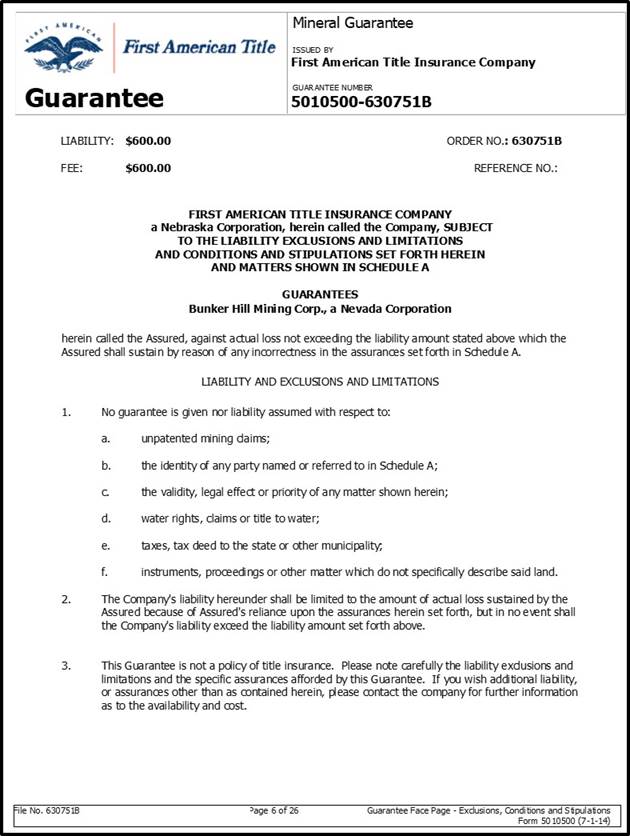
| Bunker Hill Mining Corp. | |
| Technical Report March 22, 2021 | Page 36 |

| Bunker Hill Mining Corp. | |
| Technical Report March 22, 2021 | Page 37 |

| Bunker Hill Mining Corp. | |
| Technical Report March 22, 2021 | Page 38 |

| Bunker Hill Mining Corp. | |
| Technical Report March 22, 2021 | Page 39 |
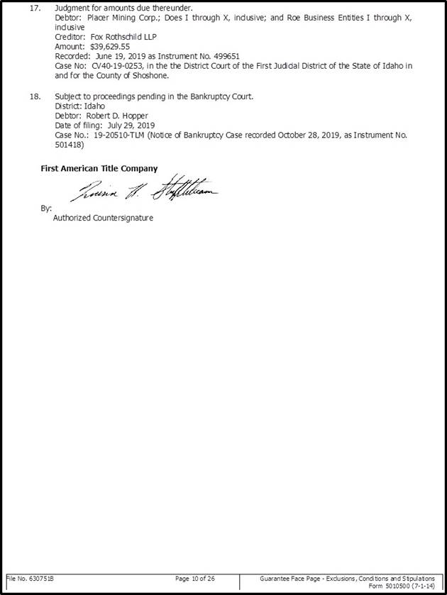
| Bunker Hill Mining Corp. | |
| Technical Report March 22, 2021 | Page 40 |

| Bunker Hill Mining Corp. | |
| Technical Report March 22, 2021 | Page 41 |

| Bunker Hill Mining Corp. | |
| Technical Report March 22, 2021 | Page 42 |

| Bunker Hill Mining Corp. | |
| Technical Report March 22, 2021 | Page 43 |

| Bunker Hill Mining Corp. | |
| Technical Report March 22, 2021 | Page 44 |

| Bunker Hill Mining Corp. | |
| Technical Report March 22, 2021 | Page 45 |

| Bunker Hill Mining Corp. | |
| Technical Report March 22, 2021 | Page 46 |

| Bunker Hill Mining Corp. | |
| Technical Report March 22, 2021 | Page 47 |

| Bunker Hill Mining Corp. | |
| Technical Report March 22, 2021 | Page 48 |
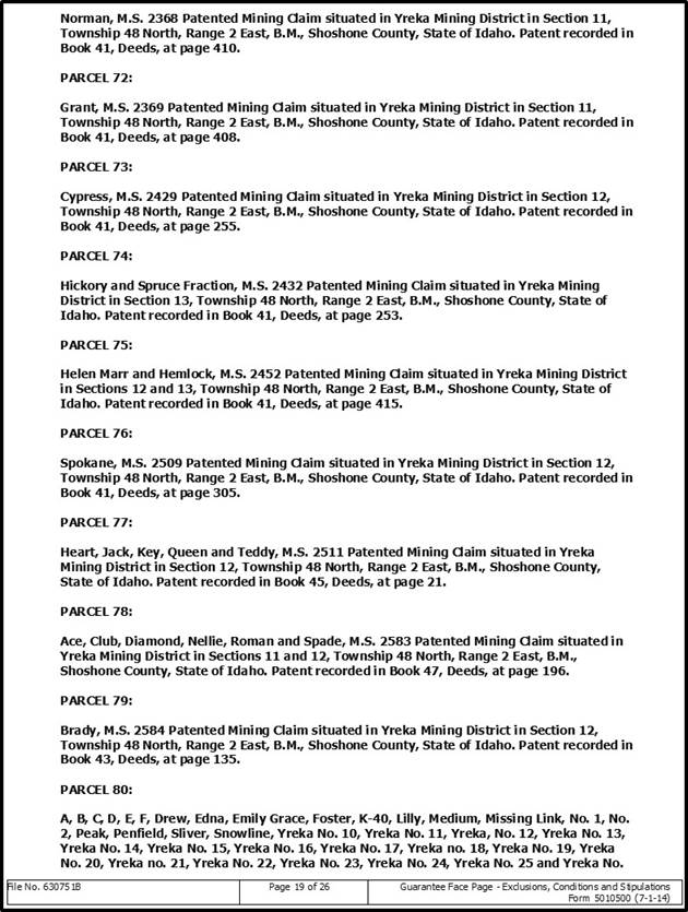
| Bunker Hill Mining Corp. | |
| Technical Report March 22, 2021 | Page 49 |

| Bunker Hill Mining Corp. | |
| Technical Report March 22, 2021 | Page 50 |

| Bunker Hill Mining Corp. | |
| Technical Report March 22, 2021 | Page 51 |

| Bunker Hill Mining Corp. | |
| Technical Report March 22, 2021 | Page 52 |

| Bunker Hill Mining Corp. | |
| Technical Report March 22, 2021 | Page 53 |
| Bunker Hill Mining Corp. | |
| Technical Report March 22, 2021 | Page 54 |
| Bunker Hill Mining Corp. | |
| Technical Report March 22, 2021 | Page 55 |

4.1.2 Other Bunker Hill Property Considerations
Patented mining claims in the State of Idaho do not require permits for underground mining activities to commence on private lands. Other permits associated with underground mining may be required, such as water discharge and site disturbance permits. The water discharge is being handled by the EPA at the existing water treatment plant. The Company expects to take on the water treatment responsibility in the future and obtain an appropriate discharge permit.
The land package included in the lease with an option to purchase between BNKR and PMC includes approximately the same land and mine infrastructure that was transferred to PMC in 1992. Over 90% of surface ownership of patented mining claims not owned by PMC is owned by different landowners. These include: Stimpson Lumber Co.; Riley Creek Lumber Co.; Powder LLC.; Golf LLC.; C & E Tree Farms; and Northern Lands LLC.
| Bunker Hill Mining Corp. | |
| Technical Report March 22, 2021 | Page 56 |
4.2 Environmental Liabilities
On May 14, 2018, BNKR, PMC, the U.S. Environmental Protection Agency (“EPA”) and Department of Justice (“DOJ”) entered into an administrative settlement agreement and order on consent. Concurrent with this administrative settlement agreement, on March 12, 2018, EPA and DOJ lodged a consent decree with the current owner of the mine, PMC. This settlement package was essential for potential redevelopment and productive use of the mine because it establishes specific limitations on liability for past environmental damage related to CERCLA, also known as the Superfund.
The Settlement Agreement and Order on Consent (the “Settlement”) specifically limits BNKR’s liability for past environmental damage in exchange for performance of obligations that are described later in the agreement.
The Settlement refers to BNKR as the “Purchaser”. In the Settlement, Paragraph II. 5. states:
“In view of the complex nature and significant extent of the work to be performed in connection with the response actions at the Mine and the Site [Bunker Hill Mine] , and the risk of claims under CERCLA being asserted against Purchaser as a consequence of Purchaser’s activities at the Site pursuant to this Settlement Agreement, one of the purposes of this Settlement Agreement is to resolve, subject to the reservations and limitations contained in Section XVIII (“Reservations of Rights by United States”), any potential liability of Purchaser under CERCLA for the Existing Contamination and Work as defined by Paragraph 10.”
In exchange for limitation on BNKR’s historical CERCLA-related liabilities, BNKR agreed to be jointly liable for specific obligations so long as its Lease with PMC remains in effect. These obligations extend through potential purchase of Bunker Hill from PMC but would terminate if the lease were to end and no purchase of Bunker Hill by BNKR was executed. The specific obligations include:
“28. Purchaser shall perform, at a minimum, all actions necessary to manage AMD as directed by EPA so as to allow necessary maintenance of and upgrades to the CTP and to avoid damaging or overwhelming the CTP, as described below in Paragraphs 29 through 34 (these actions, collectively, are the “Work to be Performed” by the Purchaser under this Settlement Agreement).
29. In-Mine Diversion System and Mine Pool. Purchaser shall construct an In-Mine Diversion System and manage the mine pool such that diverted flows of Mine Waters, as defined in Paragraph 29.a, will be stored within the mine or discharged at a controlled rate, and not result in uncontrolled discharge to the environment. The following criteria describe the performance criteria to be met.
a. Mine Waters to be Stored: Waters to be stored by Purchaser include all mine water which originate upstream of the Barney Switch within the mine, including the east side (Milo)gravity flows, the west side (Deadwood) gravity flows, and the lower country (Mine Pool) pumped flows.
b. Mine Pool Storage Volume: Purchaser shall provide storage volume using all void space (the mine workings) from a minimum of30 feet below the sill of 11 Level at the No.2 Raise to the sill of 10 Level at the No.2 Raise.
c. In-Mine Diversion System Construction: Purchaser shall construct a diversion dam system in the Kellogg Tunnel just downstream from the Barney Switch which backs up all Mine Waters into the Barney Vent Raise or other appropriate and approved location. The system shall have the capability to divert a minimum of 7,000 gallons per minute.
| Bunker Hill Mining Corp. | |
| Technical Report March 22, 2021 | Page 57 |
c. In-Mine Diversion System Activation: Purchaser shall activate the In- Mine Diversion System under the following circumstances:
(1) For initial compliance inspection: Within 70 days of the Effective Date of this Settlement Agreement, for a duration to be determined and requested by EPA during the initial compliance inspection;
(2) For emergencies: Within 4 hours of notification from EPA, for a duration to be determined and requested by EPA based on the emergency situation, which may occur at any time; and
(3) For CTP or Conveyance Line Maintenance: Within 14 days of notification from EPA, for a duration to be determined and requested by EPA based on the maintenance required.
d. In-Mine Diversion System Operation and Maintenance: Purchaser shall maintain and operate the In-Mine Diversion System until notification from EPA that the system may be decommissioned and removed, in accordance with the following:
(1) The amount of In-Mine Diversion System building materials continuously kept at the diversion structure location shall be sufficient to divert all flows as required by Paragraph 29.a, and to construct the diversion dam to provide the storage capacity required in Paragraph 29.c.
(2) The diversion dam structure, location as described in Paragraph 29.c, and adjoining ditches, are to be kept serviceable and in operable condition at all times for diversion dam construction, operation, and maintenance.
(3) The entire In-Mine Diversion conveyance system (e.g. Barney Vent Raise or other appropriate and approved location) shall be inspected a minimum of twice per year, and more frequently if there are concerns regarding its ability to convey the capacity required in Paragraph 29.c. Purchaser shall develop and maintain a written report of each inspection, and shall provide it to EPA upon request.
(4) The In-Mine Diversion conveyance system shall be cleaned, by hydraulic flushing or other means as necessary, at least once per year, and more frequently if needed to provide the capacity required in Paragraph 29.c. Purchaser shall inform EPA within 7days of completing each cleaning.
(5)
Written diversion dam construction procedures and In-Mine Diversion System operation and maintenance procedures are to be developed
and posted near the diversion dam structure location within 70 days of the Effective Date of this Settlement Agreement which provide
sufficient detail for diversion dam construction, and system operation and maintenance by all crew members. The written diversion
dam construction procedures and system operation and
maintenance procedures shall be periodically updated as needed. Purchaser shall provide the written procedures to EPA upon request.
(6) Diversion dam construction procedures and system operation and maintenance procedures required by Paragraph 29.e(5) shall be periodically practiced, at least once per year, or more frequently as needed to ensure the required diversion response time can be met. Purchaser shall inform EPA a minimum of 7 days prior to each diversion dam construction practice.
| Bunker Hill Mining Corp. | |
| Technical Report March 22, 2021 | Page 58 |
30. Kellogg Portal Contingency Diversion System. Purchaser shall obtain and store a sufficient quantity of sandbags or other appropriate materials near the entrance to the Kellogg Tunnel with the designated purpose of containing, damming, and/or rerouting any flows into the Kellogg Tunnel ditch, in order to prevent any overland flow outside the ditch.
a. Waters to be diverted: All mine waters that are not contained within the Kellogg Tunnel ditch that are either within the Kellogg Tunnel or outside of the Kellogg Tunnel in the mine yard.
b. Continency Diversion System Materials: Sandbags or other materials that could be easily transported and assembled to route mine water back to the ditch in an emergency situation.
c. Contingency Diversion System Activation:
(1) Obtain materials: Within 90 days of the Effective Date of this Settlement Agreement.
(2) Deployment of Contingency Diversion System: Within 1 hour of the first indication, or when the Purchaser knowns or should know, of Mine water flowing outside of the Kellogg Tunnel ditch, regardless of cause.
d. Continency Diversion System Operation and Maintenance: Purchaser shall maintain and operate the Contingency Diversion System until notification from EPA that the system may be decommissioned and removed, in accordance with the following:
(1) The amount of Contingency Diversion System building materials continuously kept shall be sufficient to divert all flows as required by Paragraph 30.a, and shall be deployed in accordance with Paragraph 30.c to control flows during high flow events or to respond to emergencies.
(2) The Contingency Diversion System storage location and materials are to be kept serviceable and in operable condition at all times for Contingency Diversion System construction and operation.
(3) Written Contingency Diversion System construction procedures are to be developed and posted near the diversion system materials storage location within 90 days of the Effective Date of this Settlement Agreement. Construction procedures shall provide sufficient detail for diversion system construction by all crew members. The construction procedures shall be periodically updated as needed. Purchaser shall provide the construction procedures to EPA upon request.
(4) Contingency Diversion system procedures are to be periodically practiced, at least once per year, or more frequently as needed, to ensure the required diversion response times in Paragraph 30.c can be met. Purchaser shall inform EPA a minimum of 7 days prior to each Contingency Diversion System construction practice.
31. Reed Landing Flood Control Project Operations and Maintenance.
(a) Purchaser shall conduct operations and maintenance in accordance with the Reed Landing Flood Control Project Operations and Maintenance Manual (“O&M Manual”), attached as Appendix 4 to this Settlement Agreement.
| Bunker Hill Mining Corp. | |
| Technical Report March 22, 2021 | Page 59 |
(b) Purchaser shall conduct inspections of the Reed Landing Flood Control Project in accordance with the frequency described in the O&M Manual, fill out the Inspection Checklist for each inspection, and provide a copy of the completed checklist to EPA and the State upon request.
(c) Purchaser shall remove snow and take any other necessary steps to maintain access roads to provide for safe access to the Reed Landing Project area year-round.
32. Management mine wastes, including existing piles of waste around the Mine boundaries (i.e., the slope north of the wash building and south of the City of Kellogg offices) to prevent a release of such waste into the environment.
33. Purchaser shall obtain an NPDES permit for its discharge of AMD and any other Mine-related discharges within five years of the Effective Date. Until such time, Purchaser shall continue to convey AMD to the CTP for treatment. EPA may approve the conveyance of other Mine-related discharges to the CTP for treatment during the initial five-year period. By the end of the five-year period, Purchaser shall treat all AMD and Mine-related discharges pursuant to an EPA approved treatment option and in compliance with Section 402 of the Clean Water Act,33 U.S.C.§1342. Treatment options may include:
| (a) | Entering a lease agreement with EPA providing for Purchaser to lease and operate the CTP; | |
| (b) | Purchasing and operating the CTP; or | |
| (c) | Constructing and operating a treatment plant. |
34. Treat flows from the Reed and Russell adits prior to discharge into surface waters or route back into the Mine to prevent discharge, without treatment, off-site.
35. Inspections.
(a) EPA may require an inspection of the In-Mine Diversion System following its initial construction pursuant to Paragraph 29(d)(1) to determine compliance with the requirements of Paragraph 29.
(b) EPA may have an on-site presence during the Work to be Performed. At EPA’s request, the Purchaser or Purchaser’s designee shall accompany EPA for inspections during the Work to be Performed.
(c) Purchaser shall provide specialty personal protective equipment needed for EPA personnel, transportation, and an escort for any oversight officials to perform their oversight and/or inspection duties within the mine.
(d) Upon notification by EPA of any deficiencies during the Work to be Performed on any component, Purchaser shall take all necessary steps to correct the deficiencies and/or bring the Work to be Performed into compliance. If applicable, Purchaser shall comply with any schedule provided by EPA in its notice of deficiency.
36. Emergency Response and Reporting. The reporting requirements under this Paragraph are in addition to the reporting required by CERCLA §103 and/or the Emergency Planning and Community Right-to-Know Act (“EPCRA”) §304.
| Bunker Hill Mining Corp. | |
| Technical Report March 22, 2021 | Page 60 |
(a) If any incident occurs during performance of the Work to Be Performed that causes or threatens to cause a release of Waste Material on, at, or from the Mine and that either constitutes an emergency situation or that may present an immediate threat to public health or welfare or the environment, Purchaser shall:(1)immediately take all appropriate action to prevent, abate, or minimize such release or threat of release;(2)immediately notify the authorized EPA officer, as specified in Paragraph 36.c,orally;and(3) take such actions in consultation with the authorized EPA officer.
(b) Upon the occurrence of any incident during performance of the Work to be Performed that Purchaser is required to report pursuant to Section 103 of CERCLA, 42U.S.C.§9603, or Section 304 of EPCRA, 42U.S.C.§11004, Purchaser shall also immediately notify the authorized EPA officer orally.
(c) The “authorized EPA officer” for purposes of immediate oral notifications and consultationsunderParagraphs36.aand 36.b is the EPA RPM, or the EPA Emergency Response Unit, Region 10 at206-553-1263 (if the RPM is not available).
(d) For any incident covered by Paragraphs 29.a and 29.b,Purchaser shall:(1) within 14 days after the onset of such incident, submit a report to EPA describing the actions or incidents that occurred and the measures taken, and to be taken, in response thereto; and (2)within 30 days after the conclusion of such incident, submit a written report to EPA describing all actions taken in response to such incident.
37. Purchaser shall perform all actions required by this Settlement Agreement in accordance with all applicable local, state, and federal laws and regulations, except as provided in Section 121 (e) of CERCLA, 42 U.S.C. §962 (e), and 40 C.F.R. §§300.400(e). All on-Site actions required pursuant to this Settlement Agreement shall attain applicable or relevant and appropriate requirements (“ARARs”) under federal environmental or state environmental or facility siting laws as set forth in the 1992 Record of Decision and the 2001 Record of Decision Amendment referenced in Paragraph 20 above.
X. PAYMENT
38. For so long as the Purchaser leases, owns, and/or occupies the Mine, Purchaser shall pay on behalf of PMC, as a portion of the purchase price, and in satisfaction of EPA’s claim for cost recovery against PMC as set forth in the Complaint filed by the United States on March 17, 2004 in the United States District Court for the District of Idaho (2:04-cv-00126), to EPA $20,000,000 in accordance with the following payment schedule:
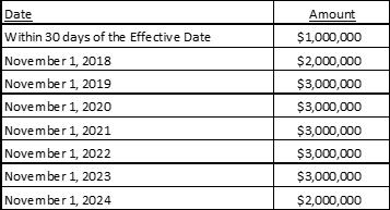
| Bunker Hill Mining Corp. | |
| Technical Report March 22, 2021 | Page 61 |
Purchaser shall make such payments for each year in which Purchaser leases, owns, and/or occupies the Mine on or after July 1. Purchaser’s liability for such payments shall not extend to any year in which Purchaser no longer leases, owns, and/or occupies the Mine after July 1.
39. Purchaser shall additionally pay EPA for water treatment costs incurred at the Central Treatment Plant(“CTP”) from December 1,2017 onward in semi-annual installments of $480,000 beginning within 30 days of the Effective Date and then every six months after December 1, 2017, for so long as Purchaser leases, owns, and/or occupies the Mine. Payments made toward water treatment and actual costs incurred will be reconciled annually. EPA will send written notification to Purchaser annually to reconcile costs paid with actual costs incurred, along with a bill for any owed costs, as appropriate. Payment of any owed costs as indicated in such notification and bill shall be paid 30 days after the date of such bill. The requirement in this Paragraph shall continue until the Purchaser finds alternative means to treat the water. “
These constitute the current environmental obligations and responsibilities of BNKR related to Bunker Hill mine site.
4.2.1 History of Superfund Liabilities
In 1983, Bunker Hill Mine was included in the 21-square mile box (the “Site”) listed on the Environmental Protection Agency’s National Priorities List as a Superfund Site. In 1992, PMC purchased a portion of the Site, which includes underground workings, mineral rights, and much of the land surface above the Mine, from Bunker Limited Partnership. PMC did not purchase the entire Complex nor the Central Treatment Plant (“CTP”) that was constructed by Gulf Resources in 1974 and operated until the sale of Bunker Hill to BLP.
At the time of purchase, PMC assumed liability for Bunker Hill Mine for environmental response costs and any claims under the Comprehensive Environmental Response, Compensation, and Liability Act (“CERCLA”), also known as Superfund.
In November 1994, Federal and State governments assumed operation of the CTP for ongoing treatment of Acid Mine Drainage.
Two years after PMC purchased Bunker Hill Mine, in 1994, EPA issued a Unilateral Administrative Order (“UAO”) to PMC directing PMC to meet three main obligations related to Bunker Hill Mine effluent and water management in and around the mine site. These included:
| ● | Keeping the mine pool (flooded workings within the mine) pumped to an elevation below the level of the South Fork of the Coeur d’Alene River (at or below Level 11 of the Mine) | |
| ● | To convey mine water to the EPA’s Central Treatment Plant for treatment unless an alternative form of treatment was approved, | |
| ● | Provide for emergency mine water storage within the mine. |
In 2017, EPA issued an additional UAO to PMC directing PMC to:
| ● | Control mine water flows to the CTP during needed upgrades at the CTP | |
| ● | In high flow periods, to conduct operation and maintenance of the Reed Landing Flood Control Project, | |
| ● | To file an environmental covenant on a portion of the Mine property regarding access and operation and maintenance, | |
| ● | Allowing PMC to fill the mine pool to Level 10 during specific events. |
EPA has incurred costs in operating the CTP, which treats the approximately 1,300 to 1,400 gallons-per-minute of acid mine drainage released from the mine on an ongoing daily basis.
The consent decree of 2018 and administrative settlement agreement, mentioned above, embody a settlement package involving PMC, BHMC, and the United States at the Bunker Hill Mining and Metallurgical Superfund Site. The consent decree and administrative settlement agreement work in tandem. The consent decree specifically incorporates the administrative settlement agreement, which will be appended to the consent decree, and which resolves PMC’s past costs liability through BHMC, the lessee and potential purchaser of the Mine. In the event that BHMC does not purchase the Mine, PMC remains liable for all unpaid past and future EPA response costs.
4.3 Observations
To the extent known, the Author knows of no other royalties, back-in rights, payments or other agreements and encumbrances to which the property is subject.
The Author knows of no other environmental liabilities to which the Property is subject.
The Author is unaware of any other permits that must be acquired to conduct work on the Property.
The Author knows of no other significant factors and risks that may affect access, title, or the right or ability to perform work on the Property.
| Bunker Hill Mining Corp. | |
| Technical Report March 22, 2021 | Page 62 |
5 Accessibility, Climate, Local Resources, Infrastructure and Physiography
The Bunker Hill Mine Project is located at Kellogg, Idaho within the Coeur d’Alene mining district, Shoshone County, Idaho. The area is accessed from Spokane, Washington via Interstate 90 east, to the 50 exit. Access to the Kellogg Tunnel is via McKinley Avenue, a public road, then using the Bunker Mine road to the Kellogg tunnel entrance. The elevation of the mine is approximately 2,300 feet above sea level.
The Bunker Hill Mine Project is in a sub-alpine mountainous region of the state and is deeply incised by the Coeur d’Alene river. Average annual rainfall is approximately 25 inches (635 mm) and average annual snowfall of approximately 1,220 mm). Summers are generally dry and warm while winter can bring heavy accumulations of snow in the mountains. Vegetation is composed mainly of grass lands on south facing slopes and conifer forest on north facing slopes. The climate is favorable for year-round mining operations.
The closest major airports to the Bunker Hill Mine Project are in Spokane, Washington, 32 miles (51.5 km) west of Coeur d’Alene on I-90 and Missoula, Montana, 108 miles (174 km) east of Lookout Pass on I-90. Necessary supplies, equipment, and services to carry out exploration and mine development projects are available in Kellogg, Wallace, Mullan, Coeur d’Alene, and Wardner, Idaho, as well as Spokane, Washington. A trained mining workforce is available in the above-mentioned communities.
| Bunker Hill Mining Corp. | |
| Technical Report March 22, 2021 | Page 63 |
The Bunker Hill Mine is one of the most storied base metal and silver mines in American history. Initial discovery and development of the property began in 1885, and from that time until the mine closed for the final time in 1991 total production from the mine totaled 42.77 million tons at an average grade of 8.43% Pb, 3.52 oz Ag/ton and 4.52% Zn. Through its history the area encompassing the Bunker Hill mine accounts for nearly 42% of the total lead, 41% of the zinc and 15% of the silver production in the Coeur d’Alene Mining District. Only the Sunshine and Galena mines have produced more silver. Over this long history, over 40 separate mineralized zones were exploited at the Bunker Hill mining complex.
6.1 Discovery and Historical Ownership
Discovery of Bunker Hill occurred in the summer of 1885 when Noah Kellogg, a prospector from Murray Idaho, discovered the Bunker Hill outcrop. Through a series of partnerships and sales, The Bunker Hill and Sullivan Mining and Concentrating Company was incorporated in July of 1887. Operations focused on the upper levels easily accessed by means of surface portals. Mined material was transported by aerial tramway to the mill site in Kellogg. By 1893 mining had progressed to the creek level near Wardner, ID where it became evident that continued operations would require a significant investment to access down dip extension to mineralized veins and bedding. Work began on the eponymous Kellogg Tunnel during 1893 which was completed in 1902. The tunnel provided access to the 9-Level (2,406 msl) of the mine which became the main area of operations for the mining operation. A series of shafts provided access down-dip where exploitation of the resource reached the 28-Level (-1,200 msl). The company began public trading in 1905. In 1912 construction of a lead smelter commenced which became operational five years later in 1917 followed by an electrolytic zinc smelter in 1927. In 1956 the corporate name was shortened to The Bunker Hill Company where operations continued until 1968 when, as result of a hostile merger, the Bunker Hill Company became a wholly-owned subsidiary of Gulf Resources and Chemical Corporation.
In 1981 a decline in metal prices led to a slow-down in operations at the mine and resulted in significant lay-offs. Continued uncertainty about metal prices, the unlikelihood of winning wage rollbacks from labour, and increasingly stringent environmental regulations contributed to Gulf Resources’ decision in August 1981 to close its Bunker Hill operations and put the company up for sale. In 1982 the company was sold to the Bunker Limited Partnership. BLP reopened the mine while keeping the lead and zinc operations closed. The mine operated from 1988 to 1991 at which point BLP filed for bankruptcy. On May 1, 1992, mineral rights were transferred to Robert Hopper, owner of Placer Mining Co., of Bellevue, Washington.
On August 28, 2017, Bunker Hill Mining entered into a definitive agreement with Placer Mining Corp. on a lease with an option to purchase the Bunker Hill Mine. As of the date of this Technical Report the agreement has been modified and extended through August 2022. The agreement includes mining claims, surface rights, fee parcels, mineral interests, existing infrastructure, machinery and buildings at the Kellogg Tunnel portal in Milo Gulch, or anywhere underground at the Bunker Hill Mine Complex; except exclusions of the Machine Shop Building and Parcel, unprocessed mineralization on deck and residual lead/zinc mineralization mined and broken, but not removed from the Bunker Hill Mine. The lease period can be extended by a further 12 months at the Company’s discretion. During the term of the lease, the Company must make US$60,000 monthly mining lease payments. Bunker Hill Mining has an option to purchase the Bunker Assets at any time before the end of the lease for $11M ($5.9 cash, $M4.9 stock). There are no other royalties or other encumbrances in the modified lease terms.
6.2 Historic Operations
The Bunker Hill lode, in Milo Gulch, was discovered by prospector Noah S. Kellogg on September 9, 1885. Legend has it that Kellogg’s wandering burro found the mineralized outcrop. Grubstaking a prospector was common in the early days of the Coeur d’Alene Mining District and it was under these arrangements that local Murray merchants John T. Cooper and Origin O. Peck outfitted Noah Kellogg when he set out to look for gold up the South Fork of the Coeur d’Alene River in August of 1885.
Soon after the discovery, the partners entered into an agreement with Jim Wardner whereby he secured capital for development of the mine and construction of a mill. After negotiating a contract with Selby Smelting Company to treat the process plant product, Wardner was able to interest a syndicate who organized the Helena Concentrating Co. This company built the first process plant on the Sullivan side of the gulch in July of 1886.
| Bunker Hill Mining Corp. | |
| Technical Report March 22, 2021 | Page 64 |
In 1887 Simeon Gannet Reed purchased the claims and process plant for a total of $750,000 and, in partnership with Martin Winch and Noah Kellogg, incorporated the Bunker Hill and Sullivan Mining and Concentrating Company. The financial headquarters of the company was transferred to San Francisco in September 1891. The Oregon corporation was dissolved on March 24, 1924, and the company was reincorporated in Delaware. In 1956, the name was shortened to The Bunker Hill Company.
As the mine production increased, a process plant of larger capacity was needed, and in 1891 a 400 ton (363 tonne) per day process plant was built in the main valley below the confluence of Milo Creek with the South Fork of the Coeur d’Alene River. To transport mineralization to the process plant, an aerial tramway, with a horizontal length of 10,000 ft (3,048 m), was constructed from Wardner. This tramway served to transport all mine mineralization until the two-mile (3.2 km) Kellogg Tunnel was completed in 1902. In 1898 the Bunker Hill and Sullivan Mining and Concentrating Co. and the Alaska Treadwell Company each purchased 31.34 percent of the stock of the Tacoma Smelter on Puget Sound, rehabilitated the plant, and thereby provided a facility for smelting. When the smelter closed its lead plant in 1912, lead from the Bunker Hill Mine was shipped to Selby, California, and East Helena, Montana for processing. In 1916 the company began the construction of a lead smelter at Kellogg which went into operation in July 1917.
The Kellogg Tunnel started in 1893 and completed in 1902, permitted exploration work to take place on the tunnel level and the intervening ground between the tunnel and the surface. This resulted in the opening up of the Carey and July stopes on the 7th and 8th levels and the March stope on the tunnel or No. 9 level. These were three of the highest grade and most productive stopes in the history of the mine.
At Kellogg, the company operated the Bunker Hill Lead-Zinc-Silver Mine and the Crescent Silver-Copper Mine, a lead smelter and refinery, electrolytic zinc reduction plant, cadmium plant, zinc fuming plant, sulfuric acid plant and a phosphoric acid plant. Historically, the Bunker Hill Mining Company accurately recorded the production grades from individual mining areas. In the early mine life, a portion of the mining was carried out by contractors or “leasers” who were paid for the mineral content of the mineralization shipped to the process plant by sampling each carload of mineralization shipped. Accurate records of their production are documented and represent the grade of mineralization shipped for processing.
Pre-development exploration drilling and assaying was limited the early years of production and accelerated later in the mine’s life with a total sum of over 3500 drill holes representing over 200,000 feet of drilling. Early exploration was primarily done by exploratory drifting and cross-cutting. Over the course of several years in the late 1970s, a dedicated team of geologists conducted ground-breaking research on the mineralized controls of the veins. The research for the first time defined distinct stratigraphic horizons in the upper Revett formation that could be correlated and mapped over distances of thousands of feet. The 1970s research ended shortly before the mine closed, and the new concepts were never fully applied to exploration.
6.3 Past Production
Total production from the past-producing Bunker Hill Mine from 1885 through 1981 is 35,779,448 tons (32,458,578.5 t) grading 8.76% lead, 3.67% zinc and 4.52 oz/ton (155 g/t) silver (Meyer and Springer 1985, Bingham 1985).
The largest individual zones include the March with 4,735,795 tons (4,296,242 tonnes) grading 12.03% lead, 2.25% zinc and 5.22 oz/ton (179 g/t) silver, and the Emery with 3,744,798 tons (3,397,224.5 tonnes) grading 10.31% lead, 3.86% zinc and 6.17 oz/ton (211.5 g/t) silver (Meyer and Springer 1985).
The highest grade Silver zones include the Caledonia mine with 263,182 tons grading 12.6% lead and 30.75 oz/ton silver, the Senator Stewart mine with 1,014,814 tons grading 7.9% lead and 6.34 oz/ton Silver, the J-Vein with 1,130,414 tons grading 9.8% lead and 7.59 oz/ton Silver, and the Truman-Ike vein with 1,861,295 tons grading 10.31% lead and 7.47 ox/ ton Silver.
These historical production figures do not include production from the 18-month period when the mine was re-opened between 1989 and 1991.
Following its discovery in 1885, the Bunker Hill Mine operated continuously until 1981, except in times of labor stoppages. The mine was also operated from 1989 until January 1991 by the Bunker Limited Partnership.
During the mine operations, production came from 15 or more separate deposits mined over a vertical range of 4,800 ft (1,463 m) from 3,200 ft (975 m) above sea level to 1,600 ft (488 m) below sea level (Figure 6.1). The main entry was through the Kellogg Tunnel at 2,400 ft (732 m) elevation, (on nine level) and access to deposits below that level was by means of three major inclined shafts and other auxiliary inclines. In total, well over 100 miles (161 km) of major horizontal openings were maintained, as well as six miles (9.7 km) of shafts and raises.
| Bunker Hill Mining Corp. | |
| Technical Report March 22, 2021 | Page 65 |
Table 6-1 Mine Production by Zone
| Mineral Zone | Final Year of Production | Tons Mined | Pb % | Ag opt | Zn % | |||||||||||||||
| Emery | 1981 | 3,744,798 | 10.31 | 6.17 | 3.86 | |||||||||||||||
| Truman - Ike | 1967 | 1,861,295 | 9.79 | 7.47 | 2.10 | |||||||||||||||
| Mac | 1981 | 1,226,038 | 9.58 | 5.34 | 4.39 | |||||||||||||||
| Roger (Pb) | 1980 | 253,511 | 8.20 | 3.56 | 3.09 | |||||||||||||||
| Shea | 1981 | 2,088,383 | 7.31 | 4.27 | 3.55 | |||||||||||||||
| Tallon | 1980 | 1,270,295 | 2.13 | 1.06 | 7.71 | |||||||||||||||
| Veral | 1975 | 357,765 | 8.86 | 4.81 | 0.43 | |||||||||||||||
| Pate | 1967 | 322,271 | 9.42 | 4.36 | 6.80 | |||||||||||||||
| Miscellaneous | 1900 | 388,060 | 8.72 | 4.85 | 3.25 | |||||||||||||||
| Tony | 1979 | 362,393 | 1.94 | 1.24 | 9.72 | |||||||||||||||
| South Chance | 1980 | 7,175 | 3.41 | 1.85 | 1.77 | |||||||||||||||
| Orr | 1981 | 323,359 | 5.91 | 2.87 | 2.24 | |||||||||||||||
| Forrest | 1963 | 9,273 | 2.41 | 1.01 | 0.43 | |||||||||||||||
| Francis | 1981 | 972,315 | 11.84 | 5.68 | 4.47 | |||||||||||||||
| FW Francis | 1981 | 117,604 | 8.20 | 4.47 | 1.56 | |||||||||||||||
| J | 1980 | 1,130,434 | 9.88 | 7.59 | 0.59 | |||||||||||||||
| Rosco | 1981 | 563,340 | 1.60 | 1.24 | 5.93 | |||||||||||||||
| Brown | 1981 | 80,846 | 1.33 | 1.00 | 5.35 | |||||||||||||||
| New Landers | 1981 | 78,347 | 2.25 | 1.30 | 3.21 | |||||||||||||||
| S. Tallon | 1981 | 426,694 | 0.98 | 0.63 | 4.42 | |||||||||||||||
| Barr | 1981 | 254,016 | 8.50 | 3.76 | 0.88 | |||||||||||||||
| Frank | 1973 | 6,006 | 1.00 | 0.71 | 1.23 | |||||||||||||||
| Jersey | 1981 | 26,333 | 5.88 | 2.61 | 0.42 | |||||||||||||||
| Towers | 1979 | 636,033 | 13.26 | 5.44 | 2.46 | |||||||||||||||
| Newgard | 1981 | 1,204,015 | 1.27 | 0.72 | 3.10 | |||||||||||||||
| Small Hopes | 1980 | 825,634 | 2.46 | 1.61 | 2.98 | |||||||||||||||
| Motor | 1904 | 30,191 | 5.77 | 2.71 | 1.60 | |||||||||||||||
| Dobbins | 1976 | 429,656 | 12.05 | 4.64 | 3.09 | |||||||||||||||
| Atkins | 1981 | 245,323 | 3.44 | 2.06 | 5.49 | |||||||||||||||
| Dull | 1977 | 191 | 1.12 | 1.37 | 3.90 | |||||||||||||||
| Guy | 1946 | 99,105 | 3.76 | 1.84 | 14.26 | |||||||||||||||
| Quill | 1981 | 388,462 | 2.26 | 1.34 | 4.32 | |||||||||||||||
| Henry | 1979 | 35,172 | 7.83 | 5.08 | 1.90 | |||||||||||||||
| Steve | 1981 | 18,884 | 1.90 | 1.01 | 8.45 | |||||||||||||||
| Roger (2n) | 1979 | 665,549 | 2.64 | 1.50 | 7.24 | |||||||||||||||
| Stanley | 1957 | 1,891,285 | 7.80 | 3.30 | 9.23 | |||||||||||||||
| March | 1936 | 4,735,765 | 12.03 | 5.22 | 2.25 | |||||||||||||||
| Dobbins Cave | 1953 | 22,705 | 2.17 | 0.85 | 0.63 | |||||||||||||||
| Guy Cave | 1953 | 1,039,020 | 0.93 | 0.40 | 1.94 | |||||||||||||||
| -9 Level Miscellaneous Pb | 1970 | 2,725,251 | 12.80 | 5.99 | 2.62 | |||||||||||||||
| +3 Level Mise Pb | 1914 | 917,940 | 12.90 | 6.19 | 1.04 | |||||||||||||||
| 4 Level Mi sc Pb | 1917 | 350,191 | 10.57 | 5.18 | 1.55 | |||||||||||||||
| 5 Level Mi sc Pb | 1919 | 600,573 | 10.82 | 5.62 | 1.57 | |||||||||||||||
| 6 Level Mi sc Pb | 1943 | 580,676 | 11.20 | 5.52 | 2.26 | |||||||||||||||
| 7 Level Mi sc Pb | 1926 | 478,687 | 11.34 | 4.21 | 1.69 | |||||||||||||||
| 8 Level Mi sc Pb | 1942 | 1,849,625 | 12.38 | 5.44 | 4.90 | |||||||||||||||
| 9 Level Mi sc. Pb | 1922 | 135,042 | 13.61 | 6.10 | 2.60 | |||||||||||||||
| Miscellaneous (Zn) | 1968 | 44 | 0.19 | 0.32 | 0.54 | |||||||||||||||
| Miscellaneous [Pb-Zn) | 1958 | 1,560 | 3.70 | 2.20 | 1.40 | |||||||||||||||
| Andy | 1970 | 22,318 | 1.16 | 0.92 | 6.35 | |||||||||||||||
| Total Mine Production | 35,799,448 | 8.84 | 4.55 | 3.66 | ||||||||||||||||
| Bunker Hill Mining Corp. | |
| Technical Report March 22, 2021 | Page 66 |
6.4 Historic Mining at Bunker Hill
The primary access to the Bunker Hill Mine is the 10,000-foot (3,048 m) Kellogg Tunnel at the 9 Level elevation. The shaft extends down to the 31 level with the 29 level being the deepest developed level. The 29 level is 4,000 ft (1,220 m) below the Kellogg Tunnel. Over the 100 years of production, various mining methods have been used at the past producing Bunker Hill Mine. These include:
| ● | Square set cut and fill; | |
| ● | Captive cut and fill with classified mine tailings as backfill (below 8 Level only); | |
| ● | Shrinkage mining without backfill (above 8 Level); | |
| ● | Sub-level blast hole (Long hole) mining; | |
| ● | Sub-level caving (Guy Cave) |
Square-set cut and fill was likely the original mining method from the 1880s. The veins were mined with sets of timbers used as ground support which were then buried by sand fill pumped down from the surface. After backfilling, the next level above the sand was mined. The broken material was slushed to chutes where it dropped into passes to the level below. In other areas, a pillar mining method was used. Instead of timber as support, rib pillars were established. Sand fill was pumped in to provide the floor for the next cut. As the material was blasted, compressed air operated mucking machines transported it to a chute in the stope where it dropped into a pass to the lower level.
In the upper areas of the mine, sub-level blasthole stoping was used. Trackless equipment was used to cut levels at 40 foot (12.2 m) spacing. Long holes were drilled in the pillars between levels. The holes were blasted, allowing the material to fall to the bottom of the stope, where it was scooped by LHDs, which, depending on the area of the mine, either transported it to passes connected to the mine rail haulage system or place it on trucks for transport directly to the surface.
For mining areas above the Kellogg Tunnel, broken material was hauled by trackless equipment to one of two central passes which stored the material until it could be chute loaded into the main track haulage system operating in the Kellogg Tunnel.
For mining areas below the Kellogg Tunnel, trains powered by battery locomotives transported the material to bins located at the inclined hoisting shaft. In the shaft, skips were loaded and hoisted to skip dumps located above the Kellogg Tunnel level where the material was dumped into two large concrete bins until it could be chute loaded into the main track haulage system operating in the Kellogg Tunnel. Drawn from these storage areas by gravity, the material was chute loaded into 22 car trains pulled by 15-ton diesel locomotive and trammed two miles (3.2 km) to the surface process plant bins. The material was then processed by the Bunker Hill process plant to produce concentrates.
After 1970, diesel-powered equipment was utilized in parts of the lower mine to improve productivity and access to selected areas. In 1972, major production was resumed using bulk mining methods in the upper mine (above 9 Level), the portion above the Kellogg Tunnel, which had not been worked since the 1930s. The upper mine was partially mechanized with diesel equipment. This area of the mine produced approximately 7,000 tons (6,350 tonnes) per week (45% of total mine production) through April 1977. The upper mine was then placed on a care and maintenance basis pending improvement in the zinc market. Some production was obtained from the upper mine in the period 1978 to 1981 by extracting previously broken mineralization.
Following a 1977 strike, the lower mine resumed operations at a production rate of approximately 9,000 tons (8,165 tonnes) per week. Through April 1977, the flotation process plant operated on a three-shift basis, seven days a week, at approximately its full capacity milling rate of 2,300 tons (2,087 tonnes) per day. The concentrates produced were transported to Bunker Hill Mining Company’s lead smelter and zinc plant by railway.
The Mine and Smelter Complex were closed in 1981 as result of weak commodity prices, failure to renew labor contract, and increased environmental regulation. The Bunker Hill Lead Smelter, Electrolytic Zinc Plant and historic milling facilities were demolished about 25 years ago, and the area became part of the “National Priority List” for cleanup under EPA regulations, thereby pausing development of the Bunker Hill Mine for over 30 years. All of the cleanup of the old smelter, zinc plant, and associated sites has now been completed.
| Bunker Hill Mining Corp. | |
| Technical Report March 22, 2021 | Page 67 |
The Bunker Hill Mine main level is the nine level and is connected to the surface by the Kellogg Tunnel. Three major inclined shafts with associated hoists and hoistrooms are located on the nine level. These are the No. 1 shaft, which was used for primary muck hoisting for all locations below the nine level; the No. 2 shaft, which was a primary shaft for men and materials in the main part of the mine; and the No. 3 Shaft, which was used for men and materials hoisting for development in the northwest part of the mine. The Company believes that all three shafts remain in a condition that they are repairable and can be bought back into good working order and is in the process of beginning the engineering work to evaluate the strategic optionality of this infrastructure.
The water level in the mine is held at approximately the 11 level of the mine, 400 ft (122 m) below the nine level. The mine was historically developed to the 29 level, although the 27 level was the last major level that underwent significant development and past mining.
6.5 Historic Drilling
Over the 100-year history of active operations at Bunker Hill over 3,500 drill holes were drilled, logged and assayed. The first drillhole was drilled on the 5 level in 1889. All drill hole information including assays, lithology, and structure was recorded in hand written drill logs. Bunker Hill has painstakingly digitized the entire body of historic drill hole data and created a digital drill hole database. During the digitization process a collection of assay pulps was located and able to be associated with a subset of the historic drill holes. These pulps were re-assayed and compared to the historic assay data to verify the accuracy of the assay information.
6.6 Historical Estimates
Mining operations ceased in January 1991. The Property hosted historical estimates which were categorized using categories other than those set out in NI 43-101. Estimates were categorized as Proven Reserves, Probable Reserves, Possible Reserves and Drill-Indicated Reserves. The main difference between the Historical Estimate classifications and NI 43-101 classifications is that NI 43-101 reserves are based on the conversion of resources to reserves. Historically, US mining operations such as Bunker Hill were prohibited from disclosing resources.
Proven Reserves. Mineralization is Proven when it has been so exposed by development that its existence as to tonnage and tenor is of a high degree of certainty. A block developed and sampled on two or more sides in which continuity is established to the satisfaction of the mine’s technical staff will be considered proven. Similarly, a block developed and sampled on one side as by horizontal or vertical development through which continuity can be established, will be considered proven for a distance of 50 feet (15.25 m) from that development.
Probable Reserves. Mineralization is assigned to the Probable category when its continuity can be reasonably projected beyond the proven classification boundary. A Probable block extends between Proven blocks provided the distance between them does not exceed 100 feet (30.5 m). For a block developed on one side as by horizontal or vertical development and/or close spaced diamond drilling, the total of Proven and Probable mineralization will not exceed 100 feet (30.5 m) from the sampled side.
Possible Reserves. Mineralization is considered to be in the Possible category when its continuity can be reasonably expected to extend beyond the Probable boundary. A Possible block extends between Probable boundaries provided the distance between Probable Blocks does not exceed 200 feet (61 m). For a block developed on one side as by horizontal or vertical development and/or close spaced diamond drilling, the total of Proven, Probable and Possible will not exceed 200 feet (61 m) from the sampled development.
Meyer (1990) included mineralized material in the historical estimates on the basis of a cut-off equivalent to the production cost of mining. This was established at $23.00 per ton for material mined below the nine level. For material mined above the nine level the production cost was set at $20.00 per ton. Metals prices used were $0.40 / lb. for lead, $5.00/oz for silver and $0.65/lb for zinc. Net smelter values were calculated for the three metals using the then current metallurgical recoveries and net smelter payable values. Meyer’s (1990, 1991) historical estimates were calculated by the following method: Volumes (and subsequent tonnage) were calculated by vertical projection from level plans of mined out areas. Grades were calculated by averaging the grades on the stope assay map from which the projections were made. The Bunker Hill Mine was an active mine at the time of Meyer’s estimations and the procedures used were consistent with mineralization estimates made in other similar operations.
Meyer (1990) has reported on the historical estimate for the Bunker Hill Mine as of July 1, 1990. Meyer’s (1990) report estimated that proven and probable reserves totaled 8,266,430 tons (7,499,181 tonnes) grading 2.13% lead, 1.12 oz/ton (38.4 g/t) silver and 4.73% zinc. Possible reserves totaled 2,588,081 tons (2,347,868 tonnes) grading 2.55% lead, 1.39 oz/ton (47.7 g/t) silver and 4.48% zinc. The possible “reserves” included drill indicated material at the Quill and Guy Cave zones.
Meyer (1991) estimated the historical estimates for the Bunker Hill Mine as of January 1, 1991. Meyer’s (1991) report estimated that historical proven and probable reserves totaled 5,421,387 tons (4,918,200 tonnes) grading 2.46% lead, 1.37 oz/ton (47.0 g/t) silver and 5.17% zinc. Possible reserves totaled 3,719,722 tons (3,374,475 tonnes) grading 2.20% lead, 1.17 oz/ton (40.1 g/t) silver and 4.94% zinc. The possible reserves included drill indicated material at the Quill and Guy Cave zones.
The Author has reviewed supporting documentation including the date of the historical reserve estimate and the reliability of the estimate. The key assumptions, parameters and methods used to prepare the historic reserve estimates have been reviewed, verified and are understood. The Historical Estimate used categories other than those referenced in NI 43-101 Standards of Disclosure for Mineral Projects, May 9, 2016, which are disclosed in this Technical Report. There are no more recent mineral resource estimates available. The Author has done sufficient work to classify the verifiable portion of the historical estimate as current mineral resources. The historic estimate is not being treated as the current mineral resource
| Bunker Hill Mining Corp. | |
| Technical Report March 22, 2021 | Page 68 |
7 Geological Setting and Mineralization
7.1 Regional Geology
7.1.1 Region Stratigraphy
The Northern Idaho Panhandle Region in which the Bunker Hill Property is located is underlain by the Middle Proterozoic-aged Belt-Purcell Supergroup of fine-grained, dominantly siliciclastic sedimentary rocks which extends from western Montana (locally named the Belt Supergroup) to southern British Columbia (Locally named the Purcell Supergroup) and is collectively over 23,000 feet in total stratigraphic thickness. The Belt-Purcell Supergroup comprises, from oldest to youngest:
| ● | Black, pyritic argillites of the Pritchard formation, up to 13,100 ft thick. | |
| ● | Quartzites, siltite, and argillites of the Ravalli Group, subdivided into the Burke, Revett and St. Regis formations, up to 8,200 ft total thickness. The Revett formation is the almost exclusive host unit to mineralization at Bunker Hill. | |
| ● | Shallow-water dolomitic quartzites and arenaceous dolomites of the Middle Belt Carbonate Group, up to 6,560 ft thick. | |
| ● | Interbedded quartzites and argillites of the Missoula Group, up to 1,640 ft thick. |

Figure 7-1 Stratigraphic section of Belt-Purcell Supergroup across northern Idaho and western Montana.
Mineral deposits noted in red at stratigraphic position of host rocks (from Lyndon, 2007).
| Bunker Hill Mining Corp. | |
| Technical Report March 22, 2021 | Page 69 |

Figure 7-2 Geologic map of Shoshone County, clipped and centered on Coeur d’Alene Mining District, Bunker Hill
Mine highlighted in red (IGS 2002).
| Bunker Hill Mining Corp. | |
| Technical Report March 22, 2021 | Page 70 |
The sediments of the Belt-Purcell rocks were deposited in an intracratonic basin associated with rifting in the interior of the Rodinia Supercontinent. As no known volcanism is associated with this rifting, it appears to be related to lithospheric tension and not the ascent of a magmatic plume in the crust shoving overlying sediments aside, making it a passive rather than an active rift system (Lyndon, 2007).
Contacts between rock units and progression between lithologies show a continuously aggrading sequence of deposition, largely from flooding in fluvial and tidal systems, with no erosional contacts or large-scale channel-scouring bedforms. This indicates deposition in a low-energy, shallow-water environment in a rapidly subsiding, sediment-starved basin with ample accommodation space for sediment inflow. Carbonate units in the Supergroup show periodic connections between the depositional basin and the open ocean allowed for shallow flooding of the entire basin by seawater, although lack of tidal and wave scouring textures or transgressive-regressive depositional and erosional sequences indicate that the connection was never large enough for transmission of tidal or oceanic storm forces.
Individual sedimentary beds and units within the Belt-Purcell Supergroup do not display strong lateral continuity, reflecting active subsidence in the basin and varying sediment sources. Thickening of the stratigraphic units to the south suggests that the basin in which they were deposited was growing at depth and laterally with down-to-the-south normal fault movement of crustal blocks within the basin (White, 1977). Sources for sediments have been identified as coming from the south and southwest for the majority of the life of the Basin.
Burial of the Belt Basin under later sedimentary and igneous rock packages, all now eroded away, lithified and preserved the entire stratigraphic section. Deep burial resulted in low-grade metamorphism, fusing the grains of sandstone together into hard, competent quartzites, and altering clay-rich shales into argillites and siltites (Herendon, 1983). Age dates for deposition of the Belt rocks have been established at 1400-1470 million years ago from U-Pb age dating of detrital volcanic zircon grains (Hobbs, et al, 1965).
7.1.2 Regional Structure
The rocks of the Belt Supergroup have been subjected to a complex series of deformational events over the 1.4 billion years since deposition, with the focal point of many of these forces roughly underlying the current Coeur D’Alene Mining District (“CDA”). Regardless of which detailed geologic interpretation one chooses to define individual deposits, it is clear that the rocks have seen a complex structural history of folding, shearing and faulting that have given the entire District a deep-seated plumbing system for ascending, mineral-bearing hydrothermal fluids.
The following figures and much of the interpretation are taken from United States Geologic Survey Professional Paper 478: Geology of the Coeur d’Alene District, Shoshone County, Idaho (Hobbs, et al 1965). Structure-1 through Structure-6 are the insets showing progression of structural events in Figures 7-3 and 7-4 below.
The first structural event to affect the Belt Rocks in the CDA (“D1”) was compressive forces coming from the southwest and northeast which formed northwest oriented anticline and syncline pairs with a moderate plunge to the northwest, with local overturned folds and thrust faulting (Fig 7-4: Structure-1). Following the formation of the NW trending folds, crustal stresses changed from SW-NE compression to west-northwest and east-southeast ductile shearing (“D2”). This bent and rotated the limbs of the D1 folds, creating kink-folds along the axial planes (Fig 7-4: Structure-2).
| Bunker Hill Mining Corp. | |
| Technical Report March 22, 2021 | Page 71 |

Figure 7-3- (1 of 2) Diagrammatic sequence of large-scale events in the structural history of CDA District rocks
Folding and rotation continued to intensify in a structural knot centered over the current CDA Mining District, with incipient strike-slip faulting beginning to accommodate stress within the plunging hinges and along the axial planes of the D2 folds and rotation centers (Fig X4, Structure-3). This was followed by emplacement of monzonite stocks in elongate bodies, roughly parallel to the rotated N-S fold axes, north of the ancestral Osburn Fault (Fig 7-4, Structure-4). These monzonite stocks have been dated at roughly 100 million years old by lead-alpha methods (Hobbs, et al, 1965), placing them in the same Cretaceous age range as the rocks of the Atlanta and Bitterroot lobes of the Idaho Batholith to the south. Much of the mineralization in the CDA Mining District was likely emplaced during this episode of maximum folding and stretching, along with the added heat source of the intrusions. Although there have been many theories regarding the timing, formation and source of mineralization in the CDA Mining District over the 140 years of mining and exploration, the culmination of fold intensity and intrusive emplacement agrees with most all further, more-detailed interpretations.
With continued crustal stresses, discontinuous fractures propagated through the stratigraphic section to become through-going structures. Ductile folding of the rock package ceased as strike-slip movement along these W-NW striking faults accommodated crustal stresses (Fig X4, Structure-5). This corridor corresponds with the Lewis and Clark Structural Zone, a long-lived, apparently basement-rooted, westerly trending structural zone cutting across northern Idaho and western Montana (White 2015). Further movement along these westerly faults coalesced into the Osburn Fault, the major structure throughout the Silver Valley and CDA District, which at present position shows as much as 16 miles of right-lateral, strike-slip displacement. The Structure-6 inset in Figure X4 shows the current position of the fold axes, faults and intrusive bodies.
| Bunker Hill Mining Corp. | |
| Technical Report March 22, 2021 | Page 72 |

Figure 7-4 (2 of 2) Diagrammatic sequence of large-scale events in the structural history of CDA District rocks
| Bunker Hill Mining Corp. | |
| Technical Report March 22, 2021 | Page 73 |
7.2 Property Geology

Figure
7-5 Surface geology over Bunker Hill Mine. Cross-Section A-A’ shown below in Fig. X10.
(White and Juras 1976)
7.2.1 Local Stratigraphy
Mineralization at the Bunker Hill Mine is hosted almost exclusively in the Upper Revett formation of the Ravalli Group, a part of the Belt Supergroup of Middle Proterozoic-aged, fine grained sediments (Fig. 7-5). As the Middle and Lower Units of the Revett formation and the stratigraphically overlying St. Regis formations do not host appreciable mineralization, mine geologists at Bunker Hill did not spend a great deal of time mapping or interpreting these units. As this is still the case as far as known mineralization or exploration targets, the local rock package is restricted to the Upper Revett formation sediments. One west-northwest striking mafic dike has been noted on mine maps in development drifts to the north of any known mineralization, but little is known of this feature and no mineralization or alteration is associated with it.
Given the ubiquitous fine-grained nature of Belt Group sediments in the CDA District, putting together a proper stratigraphic section had always proved enigmatic to area geologists, with correlation between adjacent mines difficult due to discontinuity of units and differences in nomenclature. It was recognized that there are fairly abrupt lateral gradations of compositions and textures within the stratigraphic package, reflecting active subsidence of the Belt Basin and the changing influx of sediments. As has long been informally recognized by mine operators in the Bunker Hill area, preferential host rocks for mineralization are the more competent quartzite units within the Upper Revett formation.
| Bunker Hill Mining Corp. | |
| Technical Report March 22, 2021 | Page 74 |
For much of the history of the Bunker Hill, mining focused on mineralized zones and veins that outcropped on surface, and so little geologic knowledge was needed to find or follow these structures. By the mid 1970’s, these large ore bodies (such as the March) had been mined out, and the Company had to develop an exploration plan to locate additional mineable resources.
Following extensive mapping, measured stratigraphic sections and comparison with drill core and mine level mapping during a research program in the 1970’s, Brian White developed a detailed stratigraphic section for the Upper Revett formation in the immediate Bunker Hill Mine area that greatly simplified interpretations of structural offsets and eliminated needless ranges of description for rocks of the same lithologic facies (Fig. 7-6).
White delineated the rocks in the Bunker Hill Mine area into three lithologic types:
(Q) Quartzite: fine-grained, clean and well sorted with a vitreous appearance on fractures, almost entirely quartz with minor feldspar, thick bedded to massive, local crossbedding. Quartz grains fully fused, continuous metal streak with nail scratcher, ideal host to mineralization. Generally white to light gray color.
(SQ) Sericitic Quartzite: dominantly fine-grained quartz sand protolith, feldspar and clay content altered and mobilized to interstitial sericite during burial metamorphism. Fairly competent, intermittent streak with metal scratcher, thick to thin bedded, decent to marginal host rock to mineralization. Light to dark gray in color, distinct light green-gray in weathered outcrop.
(SA) Siltite-Argillite: anything that is a dominantly mud, silt or clay protolith, representing a distinct lower-energy, deeper water depositional facies than the shallow-water to sub-aerial, relatively high-energy quartzite units. Thin, planar bedding with local ripple marks and sediment loading textures. Very poor host rock for mineralization unless cut obliquely by vein structures. Highly variable color, generally shades of green with occasional shades or red and purple.
A series of distinct sediment packages were identified in the Upper Revett formation across the mine workings. From bottom to top of the section (Fig. X6), these are the:
Lower L-0 though L-6 quartzites
Middle M-1 siltite-argillite, M-2 quartzite and M-3 siltite-argillite
Upper U-1,2,3,4 and 5 quartzites and U-6 siltite-argillite
| Bunker Hill Mining Corp. | |
| Technical Report March 22, 2021 | Page 75 |

Figure 7-6 Stratigraphic section of Revett formation in Bunker Hill area (White, 1976)
Geologic mapping and interpretation progressed by leaps and bounds following the recognition of a predictable stratigraphic section at the Bunker Hill Mine, and enabled the measurement of specific offsets across major faults, discussed in the following section. From an exploration and mining perspective, there were two critical conclusions from this research: all significant mineralized shoots are hosted in quartzite units where they are cut by vein structures, and the location of the quartzite units can be projected up and down section, and across fault offsets, to targets extensions and offsets of known mineralized shoots and veins.
An example of mine level mapping from Bunker Hill Level 17 is shown in Figure 7-7 below. Quartzitic packages are the orange colored units and the outline of mine workings is in black along the right half of the image. As one can see from the drill holes shown in the center with lithology logging drawn on, exploration efforts in the 1970’s were targeting quartzite units at fold hinges and intersections with mineralized structures.
| Bunker Hill Mining Corp. | |
| Technical Report March 22, 2021 | Page 76 |

Figure 7-7 Geologic Map of Bunker Hill Mine 17 Level showing quartzite units and exploration drill holes
7.2.2 Local Geologic Structure
The rocks of the Bunker Hill Mine have a very complex geologic history, as described in Section 7.1.2 of this Technical Report. On a mine scale, many of the regional patterns are evident in local folding and fault offsets.
7.2.2.1 Folding
The oldest structural feature evident on the Property is the Tyler Ridge flexure, the anticlinal portion of a parasitic fold on the north flank of a large-scale, northwest-trending fold to the southwest that formed from the D1 event described in Section 7.1.2 (Figure 7-3, Inset Structure-1). This fold originally trended W-NW, and plunged gently NW (Juras, 1977).
The next significant structural event to affect the rocks was the upwarping of the Big Creek anticline, an E-W trending fold with a slight dip E. The rocks of Bunker Hill are in the north limb of this anticline, which has been overturned to the north due to compressive stress from the south. The axial plane of the Tyler Ridge Flexure has thus been rotated to plunge to the W-NW at -20 to -35 degrees (Fig. 7-8), and the local bedding rotated to be overturned and dipping steeply to the S-SW (Juras, 1977). The Bunker Hill Mine workings lie in the north limb of both the Flexure and the Big Creek Anticline, and mineralization roughly parallels the plunge of the apex of the Tyler Ridge Flexure.
| Bunker Hill Mining Corp. | |
| Technical Report March 22, 2021 | Page 77 |
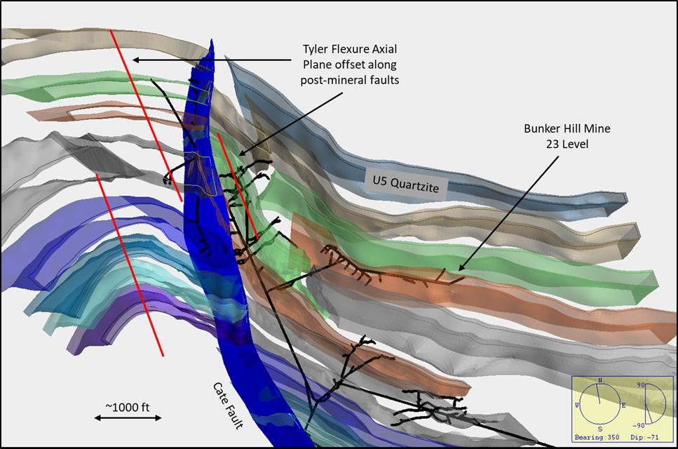
Figure 7-8 Isometric view of Vulcan 3D model of L-0 through U-5 Quartzite units, looking nearly down-plunge on
the Tyler Ridge Flexure axial plane, shown as red lines offset by faults. Note post-fold offsets of stratigraphy
along numerous faults, only Cate Fault i
Structural preparation in the form of brecciation along the apexes of folds, bedding-plane shearing and faulting, axial planar fracturing, and flexural cracks in quartzite beds of the Upper Revett formation during these two structural events, shown diagrammatically in Figure 7-9 below, was undoubtably critical for the emplacement of mineralization. Some workers have concluded that mineralization at Bunker Hill was emplaced contemporaneously with these folding events. Reports by Dwight Juras (1977, 2020) have indicated that siderite-pyrite-sphalerite veins (Bluebird Veins) formed during this W-NW folding event, and later, cross-cutting argentiferous galena-chalcopyrite-pyrite-quartz veins (Galena-Quartz Veins) were emplaced during formation of the E-W trending, north-verging Big Creek Anticline. Others have argued that metals in the CDA District sourced from a shear-zone type base metal + silver mineralizing system, similar to a shear-zone hosted gold deposit, associated with later movement in the Lewis and Clark Structural Zone, with mineralizing fluids taking advantage of the same structural preparation in the quartzite host rocks (White 1994, 2015).
| Bunker Hill Mining Corp. | |
| Technical Report March 22, 2021 | Page 78 |
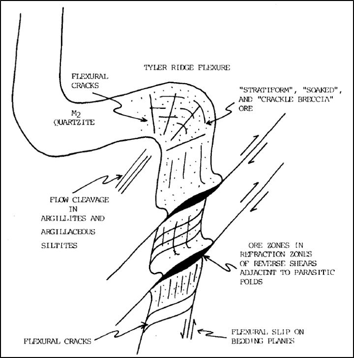
Figure 7-9 Diagram of structural preparation of a quartzite bed from folding stresses (Juras and Duff, 2020)
7.2.2.2 Faulting
The district-scale Osburn Fault lies immediately to the north of the Bunker Hill Mine workings, striking E-W and dipping steeply south. This fault has had the most recent and significant movement in the CDA District, with up to 16 miles of right-lateral displacement. Because of this movement, and the likely rotation of other fault surfaces and bedding that are cut by it, many of the faults at Bunker Hill appear in plain view to be S-SE horsetail splays out of the Osburn Fault (Fig. 7-5). This is not the case however, as the other faults in the Mine area pre-date the Osburn Fault and resulted from entirely separate and different stress regimes.
The oldest faults at Bunker Hill are N-NW striking, flat to gently SW dipping, and have from 100-1600 ft of reverse offset, generally to the north or east (Towers, Motor, Sierra Nevada and others). These structures host vein mineralization in some areas where crossing preferential quartzite units, but otherwise cut and offset all vein types in the mine (Juras and Duff, 2020). These are the least understood of the faults at the mine, as it is difficult to represent flat-lying structures with traditional geologic mapping methods, and difficult to drill-test these structures from mine workings at similar elevations.
| Bunker Hill Mining Corp. | |
| Technical Report March 22, 2021 | Page 79 |
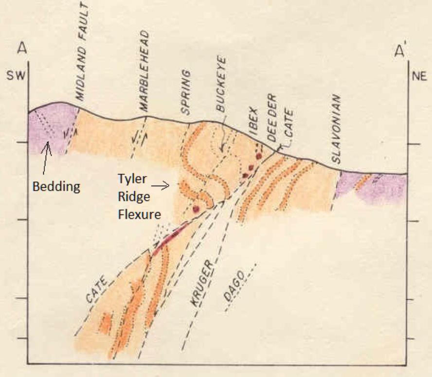
Figure
7-10 Cross-section A-A’ looking W-NW, not to scale, from surface geology map Fig. X5
(White and Juras 1976). Darker orange is quartzite bed in Upper Revett Formation, legend on Fig. X5
The next faulting event is a series of steeply W-NW striking, south-dipping normal faults with significant offset down to the south. The most prominent of these, the Kruger, Slavonian and Dull Faults from east to west (Fig. 7-10, Slavonian and Dull are unlabeled fault traces between Kruger and Cate Faults), each have +1000 ft of displacement, and combined with other subparallel faults, the total displacement across these structures is estimated at more than 6000 ft (Farmin, 1977). These faults run subparallel to bedding in the Upper Revett formation, generally staying in the same siltite-argillite bed for great distances until they cross a structural inflection and jump up or down in the section. This factor, along with conspicuously thin zones and limited fault gouge given the amount of displacement, indicates these are largely bedding-slip faults resulting from differential movement between beds during folding. There is a similar set of faults in the hanging wall of the younger Cate Reverse Fault (Marblehead, Buckeye, Ibex and others) that also show down-to-the-south, normal-fault offset. These are likely directly related to the faults in the footwall of the Cate Fault, at least in age and genesis, but the large reverse offset along the Cate Fault has obscured this relationship.
The youngest and most prominent major fault in the Mine is the Cate Fault, a NW-striking, SW-dipping reverse fault with 400 vertical feet of up-to-the-north displacement and some rotational movement (Fig. 7-8). This fault likely formed at the waning stages of the northward-verging folding that produced the Big Creek Anticline, and seems to have accommodated a transition from ductile to brittle deformation, possibly due to a shallower depth within the crust after up-warping from folding. The Cate Fault is younger than all major folds, faults and veins in the Mine. Movement along the Cate Fault, and more recent movement along the Osburn Fault, has caused slight remobilization along many older structures, resulting in small-scale structural textures that have been troublesome to placing actual structural events in the proper chronological order.
| Bunker Hill Mining Corp. | |
| Technical Report March 22, 2021 | Page 80 |
Much of the historic production at Bunker Hill came from W-NW trending, SW dipping veins with sphalerite-pyrite-siderite mineralization (“Bluebird Veins”) and hybrid ore bodies where these veins are cut by later NE striking, SE dipping Galena-Quartz Veins, discussed in next section. Because the Cate Fault follows the trend of the Bluebird Veins, it was thought that the Cate Fault and related structures were the plumbing and driving mechanism behind vein emplacement for the first 90 years of mining. Geologic studies towards the end of major mining operations at Bunker Hill in the late 1970’s established that movement along the major faults mapped on surface and underground cuts and offsets all know types of mineralization (Juras 1977).
7.2.2.3 Veining
The Bunker Hill Mine has largely exploited mineralization that in a general sense can be defined as vein deposits. These will be discussed in detail in the following section of this Technical Report, but are also included here to provide proper structural context. The vein deposits can be divided into two groups based on cross-cutting relationships, orientation and mineralogy (Juras and Duff, 2020):
Bluebird Veins: Earlier event, W-NW striking, SW-dipping (Fig. 7-11), variable ratio of sphalerite-pyrite-siderite mineralization. Associated with axial planar fracturing, flexural cracks, and brecciation in quartzite beds along the hinge line of W-NW trending folds. Where mined, these are thick, tabular zones that have abrupt but gradational margins, with fairly solid zones of sulfide mineralization laterally grading to mineralized sheeted fractures and thin stringers along bedding in adjacent sediments. These “Stringer” zones can be large enough to constitute economic mineralization, as in the Guy Cave, UTZ, Newgard and Quill Zones, but they reflect a second-order control on mineralization.
Galena-Quartz Veins: E to NE striking, S to SE dipping (Fig. 7-11), quartz-argentiferous galena +/- siderite-sphalerite-chalcopyrite veins, sinuous-planar with sharp margins, cross-cut Bluebird Veins. Large, Hybrid mineralized zones are formed at the intersection of Galena-Quartz Veins with Bluebird Veins, where the Bluebird Vein is enriched in lead and silver by the replacement of siderite by galena.
| Bunker Hill Mining Corp. | |
| Technical Report March 22, 2021 | Page 81 |
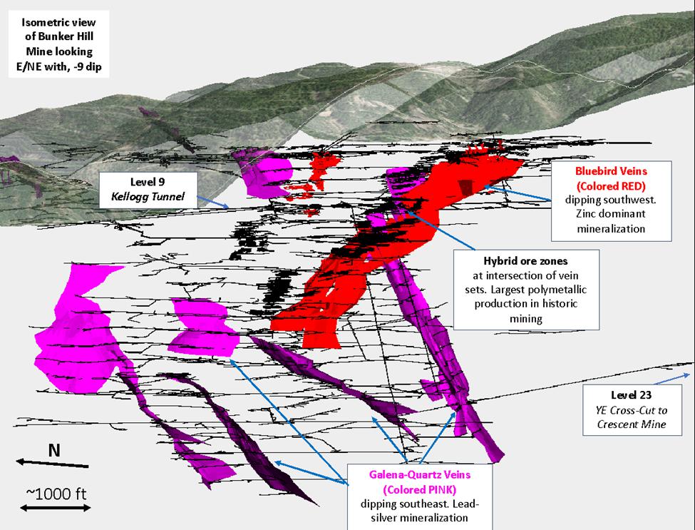
Figure 7-11 Bunker Hill Mine workings with 3D vein models showing difference between Bluebird and Galena-
Quartz Vein systems and location of hybrid mineralized zones.
| Bunker Hill Mining Corp. | |
| Technical Report March 22, 2021 | Page 82 |
7.3 Mineralization
The Coeur d’Alene (CDA) Mining District has produced phenomenal quantities of silver, lead and zinc, with significant copper, antimony and cadmium byproducts, and a peripheral belt of small gold deposits to the north. This production has come from a spectrum of deposits that reflect the varying structural, pressure-temperature and geochemical characteristics of the mineralizing systems. Mineralization at Bunker Hill has similarities to other mines in the District such as the Sunshine, Crescent and Galena, but represents a distinct suite of structural controls and mineralogy that is probably part of a large-scale zonation pattern.
The Bunker Hill Mine workings extend 8600 feet along strike of the overturned beds of the Upper Revett formation that host the ore deposits, extending 7000 feet downdip parallel to the axial plane of the plunging anticline, covering 5200 vertical feet from ~3500 ft msl to -1700 ft msl. More than 30 individually named deposits were mined historically in separate stopes, with two distinct types of deposits exploited: tabular Bluebird (BB) zones that parallel bedding and are associated with the fold structures, and later Galena-Quartz (GQ) Veins cutting through bedding with sharp walls. The Bluebird Deposits, such as the March Ore Body, have been mined for up to 1400 ft along strike, 4000 ft downdip, covering 2400 ft in elevation, with thicknesses of the generally tabular ore bodies up to 150 ft. Galena-Quartz Veins were historically mined along strike lengths of up to 800 ft, and downdip up to 3700 ft, with mined thicknesses from 5-15 ft.
Virtually all modern metal production at Bunker Hill has come from lead (galena) and zinc sulfide (sphalerite) mineralization, with silver a by-product of lead refining. Historic production in the upper levels of some of the GQ veins came from tetrahedrite (copper-iron-antimony sulfosalt, silver can substitute for copper to create very high Ag values) and cerussite mineralization (lead carbonate, surface weathering product of galena), and silver values in these working likely had some degree of supergene enrichment.
Stopes on the Jersey vein at Bunker Hill encountered oxidized lead-silver mineralization with abundant world-class pyromorphite crystals near their northern extent. Attempts were made to process this material through an oxide circuit at the mill, but the attempts proved to be non-economic. The pyromorphite zone was mined for mineral specimens after the close of major mining operations, and fine pieces from this are undoubtably some of, if not the highest value-per-ton material that has ever been extracted at Bunker Hill, gracing cabinets at most prestigious mineral museums across the world.
Mineralization at Bunker Hill falls in four categories, described below from oldest to youngest events:
Bluebird Veins (“BB”): W—NW striking, SW-dipping (Fig. 7-11), variable ratio of sphalerite-pyrite-siderite mineralization. Thick, tabular cores with gradational margins bleeding out along bedding and fractures. Detailed description in Section 7.2.2.
Stringer/Disseminated Zones: Disseminated, fracture controlled and bedding controlled blebs and stringer mineralization associated with Bluebird Structures, commonly as halos to vein-like bodies or as isolated areas where brecciated quartzite beds are intersected by the W-NW structure and fold fabrics.
Galena-Quartz Veins (“GQ”): E to NE striking, S to SE dipping (Fig. 7-11), quartz-argentiferous galena +/- siderite-sphalerite-chalcopyrite-tertahedrite veins, sinuous-planar with sharp margins, cross-cut Bluebird Veins. Detailed description in Section 7.2.2.
Hybrid Zones: Formed at intersections where GQ veins cut BB veins (Fig. 7-11), with open space deposition of sulfides and quartz in the vein refraction in quartzite beds, and replacement of siderite in the BB vein structure by argentiferous galena from the GQ Vein.
Mining efforts at Bunker Hill focused on different types of mineralization as discovery, technology and metal prices demanded and allowed. Early mining in the late 1800’s was focused on outcropping or near-surface, silver-rich Hybrid Zones and Galena-Quartz Veins. With the construction of a lead smelter in 1917 and an electrolytic zinc recovery plant in the 1920’s, the Company began to mine larger tonnage, zinc-dominant Bluebird zones such as the Guy Cave and the UTZ, Quill and Newgard Zones. All galena at Bunker Hill is argentiferous, and the vast majority of the silver that has been recovered over the life of the mine has come from smelting galena. Silver-rich tetrahedrite (freibergite) has been found in some of the shoots on the GQ veins, but has not been a major constituent of the overall tonnage.
| Bunker Hill Mining Corp. | |
| Technical Report March 22, 2021 | Page 83 |
The four types of mineral zones listed above are truly only two separate structural events: the NW trending Bluebird Veins and the E-NE trending Galena-Quartz Veining. Initial 3D modeling (Rangefront Technical Services 2020) and structural + mineral zonation analysis (Juras and Duff, 2020) has indicated the various vein segments are likely post-mineral offsets of two vein systems that initially comprised four distinct Bluebird Veins and three to five Galena-Quartz Veins.
Although the mineralogy of the two veins types is distinct, and there are significant differences in vein textures and structures that are not germane to this Technical Report, the physical mechanism of both types of mineralization is sulfide minerals filling open spaces (Duff, personal communication, 2020). The creation of intra-bed open space by differential movement of a folded rock package leading to a structurally prepared host rock, as shown in Figure X9, is one of the main theories regarding the origins of mineralization along these structures (Juras and Duff, 2020).
Quartzite is the primary host to mineralization in all vein types, deposited in open-space caused by refraction of the vein structure as it passes from softer siltite-argillite packages into quartzite units. The vein deflects to cross the quartzite unit more orthogonally, bending to normal with the bedding plane, in essence decreasing the length of quartzite that needs to fracture to continue propagation. Mineralizing fluids ascending the vein structure deposited sulfides in the open-spaces and pressure shadow created by these refractions. Although the veins are commonly mineralized to some degree along their entire length, economic ore shoots in historic mining operations were largely hosted in these dilated zones in quartzite beds, with the shoot plunging up and down at an orientation defined by the intersection between the vein and bedding (Juras and Duff, 2020).

Figure 7-12 Plan view and cross-sectional diagram of formation of mineralized shoot along vein in quartzite unit where rheologic contrast between argillite and quartzite causes refraction of vein surface (Juras, 1977)
The largest historically mined stopes were on Hybrid Zones such as the March, which was mined for more than 40 straight years (Fig. 7-11). The large size reflects the open space available to mineralizing fluids, in the form of the refraction shoot created in the quartzite as shown above, and the replacement of siderite (iron carbonate) in the original Bluebird Vein by argentiferous galena from the Galena-Quartz Vein. This essentially replaces portions of the Bluebird vein that are non-metal bearing with lead-silver mineralization, while leaving the zinc deposited during the BB vein event, creating high-value polymetallic grades of mineralization.
| Bunker Hill Mining Corp. | |
| Technical Report March 22, 2021 | Page 84 |
7.3.1 Alteration
Alteration in the CDA Mining District in general is not as obvious or pronounced as large, predictable zonation patterns that are commonly found around porphyry Cu, epithermal vein Ag-Au, Carlin-Type gold and many other deposit types. There are halos of disseminated sulfide minerals and siderite in wallrock surrounding both BB and GQ vein types, diminishing rapidly away from the vein contact, typically along bedding or pre-existing fractures. Some bleaching is associated with mineralized structures, and limonite staining where they outcrop on surface, but these are largely weathering features on sulfide bearing rocks.
Elsewhere in the CDA District, disseminated carbonate zonation has been observed in vein wallrock, progressing from proximal siderite (iron carbonate) to ankerite (iron-calcium carbonate) to distal calcite (White, 2015). This has not been well documented or commonly observed at Bunker Hill and so is not currently mapped or modeled.
As it is currently understood and observed, there are no distinct alteration patterns at Bunker Hill that can be used for detailed exploration targeting, nor any alteration types that would impede potential future mining operations.
| Bunker Hill Mining Corp. | |
| Technical Report March 22, 2021 | Page 85 |
The ore deposits in the Coeur d’Alene Mining District (the “District”) are amongst the most studied in the world due to the prodigious metal production and long history of mining. There are large scale similarities between the deposits as a whole, but each deposit has its own specific structural, lithologic and mineralogical zonation controls. These controls became increasingly well understood at mine-scale across the District in the 1970’s and 80’s, but regional-scale controls remain enigmatic, conceptual and subject to much academic debate.
In the most general sense, deposits in the District are orogenic, polymetallic veins with lesser disseminated mineralization emanating from the principal veins. There are clearly multiple phases of mineralization, with different causative structural events for each, hosted across the Ravalli Group stratigraphy (St. Regis, Revett and Burke formations) within the District. Lead, zinc and silver in varying ratios are the principal metals at all of these deposits, with lesser copper, antimony and cadmium historically recovered.
The veins in the District have been divided into two groups based on ore mineralogy: a low-silver galena-sphalerite-pyrrhotite-pyrite type, and a high-silver galena-tetrahedrite type (Leach et al., 1998). Prior studies had given ages of 1400-1500 Ma by Pb/Pb isotope modeling of galena from a low-silver type vein (Zartman and Stacey, 1971). In the 1998 Leach Report, gangue minerals from a high-silver type vein were age dated using Ar/Ar and Rb/Sr methods and gave ages as young as ~90-110 Ma). These disparate age dates were explained in that report by two mineralizing events: an earlier low-silver, lead-zinc-silver event during diagenesis and folding in the mid-Proterozoic, and a later high-silver galena-tetrahedrite event in the Cretaceous, associated with emplacement of the Idaho Batholith and smaller, stocks of similar age and composition to those north of the Osburn Fault in the CDA District.
Reports on Bunker Hill Mine Geology by Juras and Duff (2020) note two vein types as well (BB and GQ as described in Section 7), that roughly match the compositional differences and have the same age relationships as the two types described by Leach. Juras interprets emplacement of the earlier Bluebird series of veins at Bunker Hill to be contemporaneous with early W-NW fold development (see section 7), and the later NE Galena-Quartz veins to represent a separate, more brittle structural event, likely related to the E-W Big Creek Anticline uplift.
Both vein sets at Bunker Hill exhibit textures typical of orogenic veins, with no boiling textures or sharp textural differences from pressure-temperature changes, nor any significant wallrock alteration other than disseminations of the vein minerals. The huge vertical extent (3000-600ft+) of mineralization typical of all the vein types in the District strongly indicates that all mineralization was emplaced at moderate to deep crustal levels. Juras and Duff note examples of open-space-filling textures in sulfide minerals in veins in their 2020 report, and classify all of the veins at Bunker Hill as open space fissure veins. If all of these observations hold true, an active fold system is one of the few ways to geologically explain the spaces and pressure shadows necessary to form those open-space cavity-fill textures under the pressures and temperatures present at the time of vein emplacement.
As noted earlier in Section 7, Brian White (1994) has suggested that the entire CDA District is the base metal equivalent of a Shear-Zone hosted gold deposit, with shearing along the Osburn Fault splay of the Lewis and Clark Structural Zone, and heat supplied by the Cretaceous-aged intrusive rocks. In this model the mineralizing fluids travel up metamorphic lineations and take advantage of the same structurally prepared quartzite host rocks and structural pathways as the Juras-Duff model. Since the Juras-Duff Model is built on the same data set currently available to the Company and actively being used for geologic modeling, the fold-associated vein emplacement theory is the geologic model currently being employed to aid exploration and resource delineation drill planning.
| Bunker Hill Mining Corp. | |
| Technical Report March 22, 2021 | Page 86 |
BNKR has a rare exploration opportunity available at the Mine and has embarked on a new path to fully maximize the potential. A treasure trove of geologic and production data has been organized and preserved in good condition in the mine office since the shutdown of major mine operations in the early 1980s. This data represents 70+ years of proper scientific data and sample collection with high standards of accuracy and precision that were generally at or above industry standards at the time.
The Company saw the wealth of information that was available, but not readily usable, and embarked on a scanning and digitizing program. From this they were able to build a 3D digital model of the mine workings and 3D surfaces and solids of important geologic features. To add to this, all of the historic drill core lithology logs and assay data (>2900 holes) were entered into a database and imported with the other data into Maptek Vulcan 3D software.
By digitizing geologic maps of the mine levels, and connecting major faults, veins and stratigraphic blocks, it was possible to put into three dimensions ideas that had previously been confined to the brains of Company geologists, plan maps and paper cross-sections with data projected by hand. See an example in Figure 9-1 below, an isometric view of a cross section along the Bunker Hill #2 shaft, with slices of maps from Brian White’s 1977 stratigraphic research program shown in proper georeferenced location for the 9, 11, 13, 15, 17, 19, 21, 23, 25 and 27 Levels.
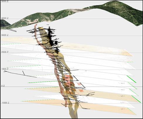
Figure 9-1 1500 ft thick cross-section along BH #2 Shaft, looking at 106 azm, -12 degrees. Mine levels and shafts are black lines, thin dark orange shape between levels on left is 3D model of U-1 quartzite unit of Revett formation, thick orange shape is M-3 siltite-argillite unit. Shapes built directly from original field mapping.
There were a number of research programs at Bunker Hill undertaken in the 1970’s to discern lithologic and structural controls on mineralization so as to conduct more effective exploration programs to replace diminishing reserves, discussed in Section 7 and 8 of this Technical Report (White, 1976, Juras, 1977). The Company is now able to apply the knowledge and conclusions from these studies in a far easier and more accurate manner than those which were available to prior generations.
| Bunker Hill Mining Corp. | |
| Technical Report March 22, 2021 | Page 87 |
The important lithologic control to mineralization are the quartzite units of the Revett formation. These have now been modeled in 3D from level maps and drill hole data, and post-mineral fault offsets can be reversed to reconstruct the folded position of the host rocks at the time of vein emplacement. Bedding patterns can be matched up at scales that were not noticeable in small-scale detailed field mapping in limited mine drift access. Fault offsets can now readily be determined and measured by positions of stratigraphic blocks. Flat faults that cut all types of mineralization, and were previously difficult to map or project, are now readily apparent in horizontal bends and offsets along units. Not enough work has been done to refine any of the above ideas down to an exact model yet, but the Company has the original data set almost entirely converted to 3D digital format. Figure 9-2 shows models of quartzite beds with offsets along modeled fault planes, cutting through the 9 Level stratigraphic map by White at 2405 ft elevation.

Figure 9-2 Isometric view of plan section through 3D lithology and Fault Models at BH 9 Level. View is looking 311 azm, -21 dip, with 100’ window on either side of stratigraphy map at 2405’ elevation.
Reversing fault offsets to reconstruct original positions has shown that the Bluebird and Galena-Quartz vein segments are offsets of original master structures for each type. Modeling is currently on-going to determine the proper offsets to reconstruct the original geometry of these vein systems at time of emplacement, which will likely identify previously unrecognized vein segments, and provide clues to locate offset segments of historically mined veins that were never found with exploratory drifting or drilling from underground.
The Company’s current primary exploration focus is on high-grade silver targets that are relatively near surface. Many of the early mines on the Property that were later consolidated under the original Bunker Hill Mining Company extracted high-grade silver mineralization from Galena-Quartz veins, such as the Veral, Sierra Nevada, Caledonia and Deadwoods Veins. Mining stopped in the early 1900’s on many of these structures when they were lost where they were cut off by faults. As the geology was poorly understood at the time, and core drilling was not available, many of the offset segments were never located and the mines shut down. With the discovery of the extremely large Hybrid March ore body in the 1950’s, mining shifted to this easily accessible, high-grade polymetallic mineralization that seemed to have no end in sight.
| Bunker Hill Mining Corp. | |
| Technical Report March 22, 2021 | Page 88 |
With so many stopes available to work on this huge Hybrid zone, proper geologic exploration fell by the wayside until the 1970’s when the aforementioned research programs were started. With mining ceasing just a few years after the completion of this research, most of the ideas and targets developed did not get tested due to lack of time and resources before the mine closed. High silver prices in the mid 1980’s caused the owners to examine silver exploration potential in close proximity to existing mine development (Meyer and Springer, 1985). A number of targets were developed, but once again, only a few were tested with any type of drilling or drifting. The geologic modeling described above is now allowing for Company geologists to examine these silver exploration targets in detail, and project lithology and structural modeling into the areas to refine and adjust the drill targeting and further evaluate the potential. Current exploration targets are portions of GQ Veins that have been offset along steep normal faults, an example of which is shown below in Figure 9-3.
The conversion of so many years of geologic work into a format in which all possible data can be isolated and looked at in 3D at the same time, same scale and same color scheme has allowed Bunker Hill Mining Company to rapidly employ the concepts and ideas of prior generations in exploration targeting, and has allowed comparison of data that was not possible with historic, paper-based geologic techniques. The Company intends to evaluate all of the exploration targets proposed in the waning stages of mining with the newly compiled dataset, and test as many of them as fit within the current realities of access and water levels.

Figure 9-3 Cross-section through Vulcan 3D models along planned drill hole trace showing expected downhole depths of projected geologic features. Historic Sierra Nevada Mine levels in black center right.
| Bunker Hill Mining Corp. | |
| Technical Report March 22, 2021 | Page 89 |
10.1 Historic Reserve Drilling Verification Program
Exploration drilling began in September of 2020 and in several locations and definition drilling to expand the Bunker Hill Resources in the UTZ started in September of 2020 and continued into assay cutoff date of March 22, 2021. This drill program produced twenty-six holes* comprising 9812 feet of core. Exploration drilling occurred from multiple surface locations, with several holes drilled at the historic Homestake portal to expand the UTZ. Also drilled were definition and exploration targets on the 5-level accessed from the Russel tunnel, and exploration targets on the 9-level accessed via the Kellogg tunnel.
The drill holes were designed by the Qualified Person (“QP”) Scott Wilson in conjunction with geologists from Rangefront Mining Services (“Rangefront”). Drill pad prep and drill rig mobility logistics were managed on site by a drilling manger from Bunker Hill, supervisory staff from American Drilling Company (“ADC”) and the onsite Rangefront geologists. A Reflex TN14 gyroscope assisted in lining up the drill rig at the collar. A 50’ survey shot was taken during drilling to allow geologists to determine hole viability. Upon reaching the target depth, a geologist observed the core and determined whether to terminate the hole or continue drilling. Upon completion, the survey tool was sent down to take an end of hole survey shot plus one shot every 100’ on the way out of the drill hole. These surveys were then approved by the geology team in accordance with industry standard practices and uploaded into the database along with collar locations picked up by the survey team. Throughout the program, Vulcan software was used to plan and modify holes, check proximity to historic workings, evaluate deviation, and assess assay results. At the end of the program, surface holes were grouted in accordance with the Idaho Water Department guidelines.
Rangefront and ADC employees maintained security of the core throughout the program. Core was initially held by ADC at the drill rig with the rigs both on the surface and underground on the 5 level. Rangefront employees made daily trips to pick up core and receive a signed Chain of Custody. On the 9 level, ADC brought the core out the Kellogg Tunnel and it would be signed over to Rangefront at the morning shift change. Winter conditions on mountainous roads eventually necessitated the deposition of core into the core shed by ADC employees.
The core was housed on site in a secure core shed where it was washed, logged, photographed, cut, sampled, and then shipped to an assay lab. Geologic characteristics noted during the logging process included lithology, color, hardness, structure, alteration, observed mineralization, point data and geotechnical data. Rangefront employees maintained Chain of Custody during the entire process.
A portion of one hole was drilled prior to the drill program beginning in September. The hole was re-entered and completed in October of 2020.
| Bunker Hill Mining Corp. | |
| Technical Report March 22, 2021 | Page 90 |
The twenty-six following tables summarize the significant intercepts encountered in the drilling campaign since September 29, 2020. The resulting assay values demonstrate the continuity of mineralization throughout the UTZ, Quill and Newgard ore zones. Interval widths do not represent the true thickness of mineralization nor can the orientation of mineralization be derived from these results.
| Drill Hole # | From | To | Interval | Lead % | Zinc % | Silver OPT | ||||||||||||||||||
| 7019 | 23.5 | 28.5 | 5 | 0.20 | 3.26 | 0.09 | ||||||||||||||||||
| 59.5 | 64.5 | 5 | 0.63 | 3.46 | 0.29 | |||||||||||||||||||
| 64.5 | 69.5 | 5 | 2.61 | 2.67 | 0.96 | |||||||||||||||||||
| 69.5 | 74.5 | 5 | 1.12 | 2.40 | 0.44 | |||||||||||||||||||
| 74.5 | 79.5 | 5 | 3.35 | 2.07 | 1.17 | |||||||||||||||||||
| 85.5 | 90.5 | 5 | 2.02 | 4.60 | 0.82 | |||||||||||||||||||
| 90.5 | 95.5 | 5 | 1.15 | 3.40 | 0.58 | |||||||||||||||||||
| 95.5 | 100.5 | 5 | 0.56 | 4.17 | 0.47 | |||||||||||||||||||
| 110.5 | 115.5 | 5 | 0.87 | 3.26 | 0.53 | |||||||||||||||||||
| 115.5 | 120.5 | 5 | 2.70 | 6.74 | 2.63 | |||||||||||||||||||
| 120.5 | 126.5 | 6 | 1.27 | 2.24 | 0.61 | |||||||||||||||||||
| 126.5 | 129.5 | 3 | 3.45 | 3.40 | 1.31 | |||||||||||||||||||
| 129.5 | 135 | 5.5 | 4.08 | 7.54 | 1.84 | |||||||||||||||||||
| 135 | 140 | 5 | 1.55 | 4.45 | 0.61 | |||||||||||||||||||
| 140 | 143.5 | 3.5 | 1.07 | 3.31 | 0.50 | |||||||||||||||||||
| 143.5 | 147 | 3.5 | 0.94 | 6.63 | 0.44 | |||||||||||||||||||
| 147 | 150 | 3 | 1.59 | 2.64 | 0.73 | |||||||||||||||||||
| 150 | 156 | 6 | 1.03 | 3.12 | 0.44 | |||||||||||||||||||
| 156 | 160.5 | 4.5 | 0.79 | 2.59 | 0.35 | |||||||||||||||||||
| 161.5 | 166 | 4.5 | 1.02 | 2.75 | 0.44 | |||||||||||||||||||
| 177 | 182 | 5 | 1.37 | 3.17 | 7.53 | |||||||||||||||||||
| 182 | 188 | 6 | 1.54 | 3.33 | 0.67 | |||||||||||||||||||
| 188 | 195 | 7 | 2.49 | 2.90 | 1.02 | |||||||||||||||||||
| Drill Hole # | From | To | Interval | Lead % | Zinc % | Silver OPT | ||||||||||||||||||
| 7021A | 525 | 530.5 | 5.5 | 2.15 | 1.33 | 1.02 | ||||||||||||||||||
| Drill Hole # | From | To | Interval | Lead % | Zinc % | Silver OPT | ||||||||||||||||||
| 7022 | 424 | 431 | 7 | 1.17 | 2.78 | 0.50 | ||||||||||||||||||
| Bunker Hill Mining Corp. | |
| Technical Report March 22, 2021 | Page 91 |
| Drill Hole # | From | To | Interval | Lead % | Zinc % | Silver OPT | ||||||||||||||||||
| 7029 | 274.5 | 279.5 | 5 | 1.55 | 2.97 | 0.47 | ||||||||||||||||||
| 307 | 309 | 2 | 13.15 | 5.31 | 5.45 | |||||||||||||||||||
| 322.5 | 324.5 | 2 | 3.31 | 0.03 | 1.05 | |||||||||||||||||||
| Drill Hole # | From | To | Interval | Lead % | Zinc % | Silver OPT | ||||||||||||||||||
| 7033A | 185 | 189 | 4 | 0.91 | 2.64 | 0.38 | ||||||||||||||||||
| 274 | 278.5 | 4.5 | 0.44 | 2.55 | 1.87 | |||||||||||||||||||
| 500 | 503.5 | 3.5 | 3.52 | 0.11 | 1.49 | |||||||||||||||||||
| 506 | 509.5 | 3.5 | 3.75 | 0.48 | 1.49 | |||||||||||||||||||
| 523 | 528 | 5 | 1.09 | 4.17 | 0.47 | |||||||||||||||||||
| Drill Hole # | From | To | Interval | Lead % | Zinc % | Silver OPT | ||||||||||||||||||
| 7035 | 74.9 | 78 | 3.1 | 1.54 | 3.87 | 1.05 | ||||||||||||||||||
| 78 | 83 | 5 | 1.66 | 3.98 | 1.14 | |||||||||||||||||||
| 85.5 | 89 | 3.5 | 1.39 | 6.77 | 1.58 | |||||||||||||||||||
| 120 | 122.5 | 2.5 | 18.55 | 0.27 | 10.44 | |||||||||||||||||||
| 191.5 | 197 | 5.5 | 1.36 | 3.09 | 0.64 | |||||||||||||||||||
| 275 | 276.5 | 1.5 | 3.02 | 0.01 | 1.49 | |||||||||||||||||||
| Drill Hole # | From | To | Interval | Lead % | Zinc % | Silver OPT | ||||||||||||||||||
| 7039 | 39 | 42 | 3 | 0.91 | 4.07 | 0.73 | ||||||||||||||||||
| 60 | 63.5 | 3.5 | 1.16 | 4.79 | 0.93 | |||||||||||||||||||
| 63.5 | 67 | 3.5 | 2.26 | 0.89 | 1.11 | |||||||||||||||||||
| 89 | 93 | 4 | 8.42 | 1.06 | 4.32 | |||||||||||||||||||
| 93 | 96 | 3 | 16.20 | 1.05 | 9.45 | |||||||||||||||||||
| 96 | 101 | 5 | 4.85 | 0.30 | 2.80 | |||||||||||||||||||
| 105.5 | 108 | 2.5 | 5.89 | 6.31 | 3.24 | |||||||||||||||||||
| 121 | 124.5 | 3.5 | 0.79 | 4.50 | 1.52 | |||||||||||||||||||
| 128 | 133 | 5 | 4.89 | 9.07 | 5.28 | |||||||||||||||||||
| 133 | 135.5 | 2.5 | 0.80 | 5.43 | 0.73 | |||||||||||||||||||
| 168 | 172.5 | 4.5 | 3.50 | 1.45 | 1.81 | |||||||||||||||||||
| 328.5 | 333.5 | 5 | 2.41 | 5.59 | 1.11 | |||||||||||||||||||
| 333.5 | 338 | 4.5 | 0.84 | 3.49 | 0.38 | |||||||||||||||||||
| 338 | 341.5 | 3.5 | 5.19 | 16.40 | 2.13 | |||||||||||||||||||
| 343 | 348 | 5 | 1.58 | 6.02 | 0.55 | |||||||||||||||||||
| 351 | 357 | 6 | 2.60 | 1.31 | 0.85 | |||||||||||||||||||
| Bunker Hill Mining Corp. | |
| Technical Report March 22, 2021 | Page 92 |
| Drill Hole # | From | To | Interval | Lead % | Zinc % | Silver OPT | ||||||||||||||||||
| 7043 | 56.5 | 62 | 5.5 | 7.68 | 0.54 | 3.79 | ||||||||||||||||||
| 206 | 211 | 5 | 2.15 | 1.40 | 0.70 | |||||||||||||||||||
| 211 | 213.5 | 2.5 | 2.12 | 1.40 | 0.70 | |||||||||||||||||||
| 213.5 | 215.5 | 2 | 8.21 | 12.65 | 2.98 | |||||||||||||||||||
| 215.5 | 218 | 2.5 | 1.37 | 9.99 | 0.47 | |||||||||||||||||||
| 218.5 | 223.5 | 5 | 1.23 | 6.87 | 0.41 | |||||||||||||||||||
| 225 | 226.5 | 1.5 | 5.45 | 26.70 | 2.25 | |||||||||||||||||||
| 226.5 | 230 | 3.5 | 2.99 | 12.70 | 1.28 | |||||||||||||||||||
| 230 | 232.5 | 2.5 | 0.67 | 2.88 | 0.26 | |||||||||||||||||||
| 232.5 | 234 | 1.5 | 1.10 | 5.46 | 0.44 | |||||||||||||||||||
| 238 | 242.5 | 4.5 | 1.07 | 4.02 | 0.41 | |||||||||||||||||||
| 249.5 | 252 | 2.5 | 1.97 | 4.60 | 0.61 | |||||||||||||||||||
| 252 | 255 | 3 | 2.71 | 9.41 | 1.02 | |||||||||||||||||||
| Drill Hole # | From | To | Interval | Lead % | Zinc % | Silver OPT | ||||||||||||||||||
| 7046 | 56 | 59 | 3 | 20.64 | 1.35 | 11.17 | ||||||||||||||||||
| 80 | 83.5 | 3.5 | 1.08 | 4.17 | 0.73 | |||||||||||||||||||
| 83.5 | 87.5 | 4 | 0.84 | 11.40 | 0.79 | |||||||||||||||||||
| 93 | 95 | 2 | 4.55 | 0.42 | 2.51 | |||||||||||||||||||
| 120 | 123 | 3 | 0.76 | 9.00 | 0.73 | |||||||||||||||||||
| 176.5 | 178 | 1.5 | 1.39 | 2.48 | 0.67 | |||||||||||||||||||
| 326.5 | 330.5 | 4 | 1.81 | 5.87 | 0.70 | |||||||||||||||||||
| 330.5 | 333 | 2.5 | 0.63 | 2.99 | 0.26 | |||||||||||||||||||
| 339 | 340.5 | 1.5 | 4.71 | 7.23 | 1.72 | |||||||||||||||||||
| 347 | 352 | 5 | 1.90 | 4.97 | 0.61 | |||||||||||||||||||
| 352 | 356 | 4 | 1.29 | 2.34 | 0.50 | |||||||||||||||||||
| 356 | 360 | 4 | 1.52 | 3.94 | 0.47 | |||||||||||||||||||
| 373.5 | 378 | 4.5 | 4.34 | 5.70 | 1.20 | |||||||||||||||||||
| 378 | 382.5 | 4.5 | 1.26 | 3.29 | 0.35 | |||||||||||||||||||
| 386 | 390.5 | 4.5 | 0.94 | 2.66 | 0.32 | |||||||||||||||||||
| 453 | 457.5 | 4.5 | 2.53 | 3.46 | 1.11 | |||||||||||||||||||
| 468 | 471.5 | 3.5 | 2.58 | 1.84 | 0.76 | |||||||||||||||||||
| 487 | 490 | 3 | 2.47 | 2.78 | 0.70 | |||||||||||||||||||
| 494 | 496 | 2 | 0.97 | 2.86 | 0.26 | |||||||||||||||||||
| 505 | 508 | 3 | 0.78 | 2.83 | 0.26 | |||||||||||||||||||
| 521.5 | 523 | 1.5 | 3.36 | 4.06 | 1.90 | |||||||||||||||||||
| Bunker Hill Mining Corp. | |
| Technical Report March 22, 2021 | Page 93 |
| Drill Hole # | From | To | Interval | Lead % | Zinc % | Silver OPT | ||||||||||||||||||
| 7047 | 68 | 71 | 3 | 1.16 | 1.95 | 2.10 | ||||||||||||||||||
| 140.5 | 144.5 | 4 | 0.65 | 3.77 | 0.70 | |||||||||||||||||||
| 150.5 | 153 | 2.5 | 3.07 | 2.67 | 1.75 | |||||||||||||||||||
| 158 | 159 | 1 | 1.47 | 4.78 | 0.88 | |||||||||||||||||||
| 162 | 163.5 | 1.5 | 10.20 | 0.72 | 4.52 | |||||||||||||||||||
| 176 | 180.5 | 4.5 | 4.87 | 0.70 | 2.01 | |||||||||||||||||||
| 180.5 | 185.5 | 5 | 11.15 | 0.51 | 5.83 | |||||||||||||||||||
| 190.5 | 192 | 1.5 | 3.93 | 3.30 | 1.81 | |||||||||||||||||||
| Drill Hole # | From | To | Interval | Lead % | Zinc % | Silver OPT | ||||||||||||||||||
| 7048 | 55 | 57 | 2 | 4.78 | 5.61 | 2.65 | ||||||||||||||||||
| 72 | 75.5 | 3.5 | 5.07 | 1.06 | 2.71 | |||||||||||||||||||
| 75.5 | 77.5 | 2 | 2.16 | 1.03 | 1.14 | |||||||||||||||||||
| 86 | 88 | 2 | 12.20 | 0.18 | 6.10 | |||||||||||||||||||
| 93 | 96 | 3 | 11.35 | 0.15 | 6.27 | |||||||||||||||||||
| 104 | 105 | 1 | 1.34 | 2.68 | 0.82 | |||||||||||||||||||
| 122 | 123 | 1 | 3.45 | 0.10 | 1.87 | |||||||||||||||||||
| 124.5 | 127 | 2.5 | 3.54 | 2.16 | 1.98 | |||||||||||||||||||
| 127 | 130 | 3 | 1.66 | 2.51 | 0.73 | |||||||||||||||||||
| Bunker Hill Mining Corp. | |
| Technical Report March 22, 2021 | Page 94 |
| Drill Hole # | From | To | Interval | Lead % | Zinc % | Silver OPT | ||||||||||||||||||
| 7052 | 0 | 4.5 | 4.5 | 19.35 | 0.55 | 6.48 | ||||||||||||||||||
| 4.5 | 6 | 1.5 | 33.97 | 1.46 | 11.40 | |||||||||||||||||||
| 6 | 9 | 3 | 2.47 | 2.36 | 0.96 | |||||||||||||||||||
| 14 | 17.5 | 3.5 | 2.75 | 2.13 | 0.88 | |||||||||||||||||||
| 17.5 | 21 | 3.5 | 3.13 | 1.83 | 1.23 | |||||||||||||||||||
| 21 | 25 | 4 | 13.35 | 7.10 | 4.32 | |||||||||||||||||||
| 25 | 26.5 | 1.5 | 8.87 | 1.03 | 2.60 | |||||||||||||||||||
| 51.5 | 52.5 | 1 | 2.63 | 2.58 | 0.99 | |||||||||||||||||||
| 56 | 58 | 2 | 2.80 | 0.83 | 0.88 | |||||||||||||||||||
| 66 | 69 | 3 | 0.78 | 3.36 | 0.47 | |||||||||||||||||||
| 108 | 110 | 2 | 3.98 | 4.52 | 1.25 | |||||||||||||||||||
| 129.5 | 130.5 | 1 | 2.04 | 6.92 | 0.76 | |||||||||||||||||||
| 138.5 | 142 | 3.5 | 0.47 | 5.08 | 0.29 | |||||||||||||||||||
| 142 | 146 | 4 | 0.69 | 3.20 | 0.35 | |||||||||||||||||||
| Drill Hole # | From | To | Interval | Recovered | Lead % | Zinc % | Silver OPT | |||||||||||||||||||||
| 7054 | 3 | 6.6 | 3.6 | 3.6 | 5.01 | 0.08 | 1.49 | |||||||||||||||||||||
| 6.6 | 8 | 1.4 | 1.4 | 6.48 | 0.15 | 2.10 | ||||||||||||||||||||||
| 8 | 11.8 | 3.8 | 3.8 | 13.70 | 0.75 | 4.35 | ||||||||||||||||||||||
| 52 | 53.8 | 1.8 | 1.8 | 7.59 | 0.09 | 2.51 | ||||||||||||||||||||||
| 82 | 83 | 1 | 1 | 1.59 | 3.16 | 0.53 | ||||||||||||||||||||||
| 85.5 | 86.5 | 1 | 1 | 1.07 | 2.29 | 0.61 | ||||||||||||||||||||||
| 123 | 124.5 | 1.5 | 1.5 | 1.67 | 2.64 | 0.55 | ||||||||||||||||||||||
| 128 | 133 | 5 | 1 | 8.58 | 0.09 | 2.25 | ||||||||||||||||||||||
| 148 | 158 | 10 | 3 | 3.22 | 0.23 | 1.37 | ||||||||||||||||||||||
| Bunker Hill Mining Corp. | |
| Technical Report March 22, 2021 | Page 95 |
| Drill Hole # | From | To | Interval | Recovered | Lead % | Zinc % | Silver OPT | |||||||||||||||||||||
| 7055 | 60.5 | 70 | 9.5 | 2 | 1.30 | 12.95 | 0.50 | |||||||||||||||||||||
| 70 | 75 | 5 | 3 | 4.21 | 21.70 | 1.63 | ||||||||||||||||||||||
| 75 | 83 | 8 | 3 | 2.34 | 14.80 | 1.02 | ||||||||||||||||||||||
| 83 | 86.5 | 3.5 | 3.5 | 4.51 | 6.54 | 1.87 | ||||||||||||||||||||||
| 86.5 | 89 | 2.5 | 2.5 | 1.82 | 9.91 | 0.76 | ||||||||||||||||||||||
| 89 | 92 | 3 | 3 | 2.85 | 4.61 | 1.23 | ||||||||||||||||||||||
| 92 | 97 | 5 | 5 | 2.18 | 1.93 | 0.76 | ||||||||||||||||||||||
| 97 | 102 | 5 | 5 | 2.21 | 4.52 | 0.90 | ||||||||||||||||||||||
| 111 | 113 | 2 | 2 | 0.67 | 2.83 | 0.29 | ||||||||||||||||||||||
| 114.5 | 116 | 1.5 | 1.5 | 2.80 | 11.75 | 0.96 | ||||||||||||||||||||||
| 125 | 128.2 | 3.2 | 3.2 | 0.98 | 3.55 | 0.38 | ||||||||||||||||||||||
| 128.2 | 130 | 1.8 | 1.8 | 5.71 | 24.00 | 2.25 | ||||||||||||||||||||||
| 142 | 145 | 3 | 3 | 1.72 | 4.50 | 0.53 | ||||||||||||||||||||||
| 145 | 146 | 1 | 1 | 4.11 | 9.20 | 1.43 | ||||||||||||||||||||||
| Drill Hole # | From | To | Interval | Recovered | Lead % | Zinc % | Silver OPT | |||||||||||||||||||||
| 7055A | 5 | 7.5 | 2.5 | 1.5 | 8.48 | 0.05 | 2.68 | |||||||||||||||||||||
| 63.7 | 67 | 3.3 | 2.5 | 7.83 | 16.15 | 3.06 | ||||||||||||||||||||||
| Drill Hole # | From | To | Interval | Recovered | Lead % | Zinc % | Silver OPT | |||||||||||||||||||||
| 7056 | 14 | 19 | 5 | 5 | 6.09 | 0.99 | 2.36 | |||||||||||||||||||||
| 53 | 55 | 2 | 2 | 5.31 | 0.07 | 1.75 | ||||||||||||||||||||||
| 84 | 88 | 4 | 4 | 5.06 | 1.00 | 1.98 | ||||||||||||||||||||||
| 88 | 91.5 | 3.5 | 3.5 | 10.05 | 0.18 | 3.00 | ||||||||||||||||||||||
| 91.5 | 94 | 2.5 | 2.5 | 8.64 | 0.31 | 2.57 | ||||||||||||||||||||||
| 94 | 97 | 3 | 3 | 13.45 | 0.88 | 3.68 | ||||||||||||||||||||||
| 97 | 101 | 4 | 4 | 3.42 | 0.32 | 1.11 | ||||||||||||||||||||||
| 101 | 104 | 3 | 3 | 10.10 | 0.49 | 2.89 | ||||||||||||||||||||||
| 108.2 | 111 | 2.8 | 2.8 | 14.70 | 1.05 | 4.40 | ||||||||||||||||||||||
| 111 | 114 | 3 | 3 | 6.33 | 0.76 | 1.90 | ||||||||||||||||||||||
| 179 | 183 | 4 | 1.5 | 0.27 | 0.05 | 34.85 | ||||||||||||||||||||||
| 196 | 199 | 3 | 3 | 1.23 | 0.08 | 16.39 | ||||||||||||||||||||||
| 214 | 215 | 1 | 1 | 2.79 | 3.10 | 4.75 | ||||||||||||||||||||||
| 215 | 216 | 1 | 1 | 3.13 | 7.93 | 1.66 | ||||||||||||||||||||||
| 216 | 221 | 5 | 5 | 1.29 | 2.15 | 0.55 | ||||||||||||||||||||||
| 231 | 232 | 1 | 1 | 2.85 | 3.11 | 0.88 | ||||||||||||||||||||||
| 235.5 | 238.5 | 3 | 3 | 2.27 | 2.82 | 0.90 | ||||||||||||||||||||||
| 246.5 | 248 | 1.5 | 1 | 11.30 | 12.05 | 3.44 | ||||||||||||||||||||||
| 249 | 250 | 1 | 1 | 2.74 | 3.52 | 0.76 | ||||||||||||||||||||||
| 272.5 | 276 | 3.5 | 3.5 | 3.59 | 0.57 | 1.40 | ||||||||||||||||||||||
| Bunker Hill Mining Corp. | |
| Technical Report March 22, 2021 | Page 96 |
| Drill Hole # | From | To | Interval | Lead % | Zinc % | Silver OPT | ||||||||||||||||||
| 7057 | 7.5 | 8.3 | 0.8 | 3.39 | 0.07 | 1.02 | ||||||||||||||||||
| 10.1 | 14.5 | 4.4 | 0.55 | 4.08 | 0.41 | |||||||||||||||||||
| 56 | 59 | 3 | 3.11 | 0.30 | 0.93 | |||||||||||||||||||
| 59 | 64 | 5 | 3.88 | 0.16 | 1.02 | |||||||||||||||||||
| 112 | 117 | 5 | 1.36 | 4.31 | 0.50 | |||||||||||||||||||
| 117 | 121 | 4 | 0.81 | 2.60 | 0.32 | |||||||||||||||||||
| 121 | 124 | 3 | 1.80 | 2.36 | 0.55 | |||||||||||||||||||
| 124 | 129 | 5 | 3.30 | 1.42 | 1.23 | |||||||||||||||||||
| 129 | 134 | 5 | 1.54 | 3.50 | 0.55 | |||||||||||||||||||
| 141 | 144 | 3 | 3.36 | 1.10 | 1.08 | |||||||||||||||||||
| 146 | 151 | 5 | 4.51 | 4.57 | 1.60 | |||||||||||||||||||
| 159 | 161.5 | 2.5 | 1.20 | 2.72 | 0.38 | |||||||||||||||||||
| 161.5 | 163 | 1.5 | 3.92 | 9.86 | 1.43 | |||||||||||||||||||
| 163 | 167 | 4 | 2.52 | 1.00 | 0.73 | |||||||||||||||||||
| 171.3 | 173 | 1.7 | 3.41 | 7.93 | 0.99 | |||||||||||||||||||
| 187 | 189.2 | 2.2 | 5.14 | 0.49 | 2.60 | |||||||||||||||||||
| 193 | 197 | 4 | 6.70 | 5.18 | 1.49 | |||||||||||||||||||
| Drill Hole # | From | To | Interval | Lead % | Zinc % | Silver OPT | ||||||||||||||||||
| 7058 | 15 | 17 | 2 | 9.10 | 5.63 | 2.89 | ||||||||||||||||||
| Bunker Hill Mining Corp. | |
| Technical Report March 22, 2021 | Page 97 |
| Drill Hole # | From | To | Interval | Lead % | Zinc % | Silver OPT | ||||||||||||||||||
| 7061 | 39 | 41.5 | 2.5 | 1.67 | 11.45 | 0.85 | ||||||||||||||||||
| 46.5 | 50 | 3.5 | 3.46 | 1.70 | 1.11 | |||||||||||||||||||
| 50 | 54.3 | 4.3 | 1.32 | 5.15 | 0.50 | |||||||||||||||||||
| 55.5 | 58 | 2.5 | 3.08 | 14.35 | 1.40 | |||||||||||||||||||
| 58 | 59.4 | 1.4 | 1.40 | 11.75 | 0.58 | |||||||||||||||||||
| Drill Hole # | From | To | Interval | Recovered | Lead % | Zinc % | Silver OPT | |||||||||||||||||||||
| 7063 | 26.5 | 28 | 1.5 | 1.5 | 0.72 | 3.56 | 0.29 | |||||||||||||||||||||
| 103 | 108.5 | 5.5 | 2 | 0.36 | 3.15 | 0.23 | ||||||||||||||||||||||
| 108.5 | 111.5 | 3 | 3 | 4.17 | 20.40 | 2.16 | ||||||||||||||||||||||
| 111.5 | 113 | 1.5 | 1 | 1.39 | 6.54 | 0.73 | ||||||||||||||||||||||
| 113 | 114.5 | 1.5 | 1.5 | 8.34 | 14.10 | 3.50 | ||||||||||||||||||||||
| 127 | 132 | 5 | 4 | 1.13 | 8.10 | 0.58 | ||||||||||||||||||||||
| 132 | 136.5 | 4.5 | 2.5 | 2.12 | 9.98 | 0.93 | ||||||||||||||||||||||
| 138 | 142 | 4 | 3 | 2.28 | 1.40 | 0.88 | ||||||||||||||||||||||
| Drill Hole # | From | To | Interval | Lead % | Zinc % | Silver OPT | ||||||||||||||||||
| 7064 | 432.2 | 434.5 | 2.3 | 6.94 | 0.01 | 4.03 | ||||||||||||||||||
*All
reported intercepts calculated at >3.99 OPT AgEq, using the following formula:
=((2200*(%Pb/100)*$Pb)/$N$3)+((2000*(H6/100)*$P$2)/$N$3)+(I6*$N$3)/$N$3
**Several areas of poor recovery indicated above under “Recovered” columns.
| Bunker Hill Mining Corp. | |
| Technical Report March 22, 2021 | Page 98 |
11 Sample Preparation, Analysis and Security
Drill core samples are cut and prepared by Rangefront employees prior to shipment. Half of the core was returned to the core boxes for archive purposes, while half was inserted into sample bags for shipment to the labs for analysis. Drill core and channel samples were stored in the core shed located on the mine site and kept under lock and key until dispatched to the lab. Access to the core shed is monitored at all times.
Prior to dispatch, core is measured and sample identification numbers are associated and assigned. Core intervals are photographed for posterity and accuracy. Half core is cut and bagged with the same sample identification number. Assay results are compared against the submitted sample numbers before acceptance of the results.
Throughout the project, multiple analytical laboratories performed assays on the drill core and channel samples collected. The QA/QC protocol in place, in conjunction with the data collected from the laboratories, determined that ALS Global provided the accurate and repeatable results that comply with both NI 43-101 and industry standards. ALS Global holds an industry standard ISO 17025 accreditation, specifying general requirements for laboratory performance.
Upon arrival, the laboratory crushed, split, pulverized and screened all samples at 200 mesh. ALS then performed a 4-acid digestion assay (ME-OG62) for silver, lead and zinc on the drill core and channel samples. Finalized results reported to Bunker Hill Exploration then entered into a geological database.
Throughout the project, multiple analytical laboratories performed assays on the 3160 drill core and channel samples collected. The QA/QC protocol in place, in conjunction with the data collected from the laboratories, determined that ALS Global “ALS”(ISO/IEC 17025:2005) provided the most accurate and repeatable results that comply with NI 43-101 and industry standards. Both Paragon Geochemical (ISO/IEC 17025:2017) and American Analytical Services, INC “American” (ISO 17025:2005) were used in the early and mid-stages of the project but failed to yield timely and repeatable results.
Upon arrival, the laboratory crushed, split, pulverized and screened all samples at 200 mesh. ALS then performed a 4-acid digestion assay (ME-OG62) for silver, lead and zinc on the drill core and channel samples. Finalized results reported to an onsite Rangefront Geologist then entered into the geologic database managed by an independent entity. All results in this Technical Report are based on and published with a high level of confidence in the work performed by ALS Global.
Blank material:
Blank material was interested into the sample sequence at a ratio of 1:20 or roughly every 100’ of core/channel sampling. At the start of the project the blank material used was marble Landscaping chips from Ace Hardware. This material failed QAQC due to contamination. Silica sand replaced the marble chips but still showed material contaminations as well. At Bunker Hill’s request, the samples sent to Paragon had blank material inserted by the lab. The samples material used were rock chips from a quarry located outside of Sparks, NV. These too had a high baseline for Pb and Zn. Finally, a lab certified blank, OREAS-21e, was used and produced satisfactory and repeatable results. The Ag element did not have the contamination as much as Pb and especially Zn did. The dashed vertical line represents the transition to the OREAS-21E material that is currently being used.
| Bunker Hill Mining Corp. | |
| Technical Report March 22, 2021 | Page 99 |


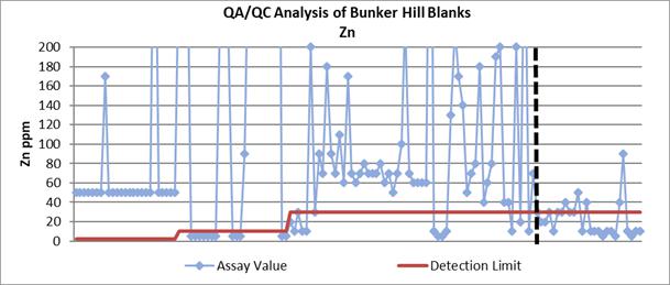
| Bunker Hill Mining Corp. | |
| Technical Report March 22, 2021 | Page 100 |
Certified Reference Materials
Certified Reference Materials (“CRMs,” “standards”) were used to monitor the accuracy of the assay results reported by all labs. Standards were inserted into the sample sequence at a ratio of 1:20 or roughly every 100’ of core/channel sampling. At the start of the project, two different VMS (volcanic hosted massive sulfide) standards were used from CDN Resource Laboratories Ltd. The below graphs show the accuracy and repeatability issues with the first two labs that ran the samples. The dashed vertical line represents the division between the QAQC at American and Paragon vs ALS.

| Bunker Hill Mining Corp. | |
| Technical Report March 22, 2021 | Page 101 |


In October, Bunker Hill discontinued the CDN Resource material and began using four different standard materials from Ore Research & Exploration PTY LTD. This material was of meta sedimentary origin and matched theoretical ore grades from Bunker Hill. Below are the charts that represent the QAQC of the most frequently used standard, OREAS-36.
| Bunker Hill Mining Corp. | |
| Technical Report March 22, 2021 | Page 102 |

| Bunker Hill Mining Corp. | |
| Technical Report March 22, 2021 | Page 103 |

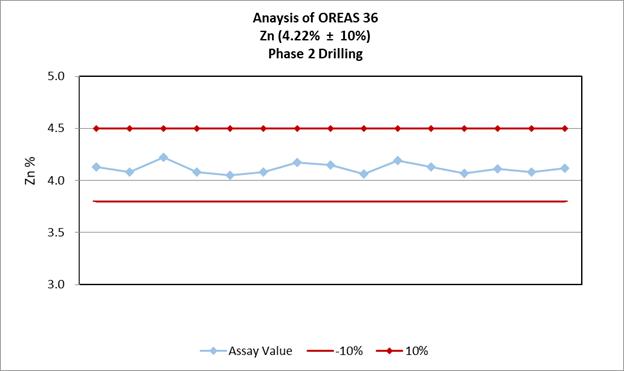
| Bunker Hill Mining Corp. | |
| Technical Report March 22, 2021 | Page 104 |
In August if was realized that no Duplicate samples were being sent into the assay lab. Bunker began a duplicate prepping procedure that involved quartering the core. Half the quarter would be grabbed by hand and put into one bag and the half into another. Due to the nuggety and fractured nature of the ore, obtaining an exact duplicate was not achievable. After investigating these results, the core shed obtained a crusher to make a more homogenic sample for a true duplicate that will tests the labs repeatability.

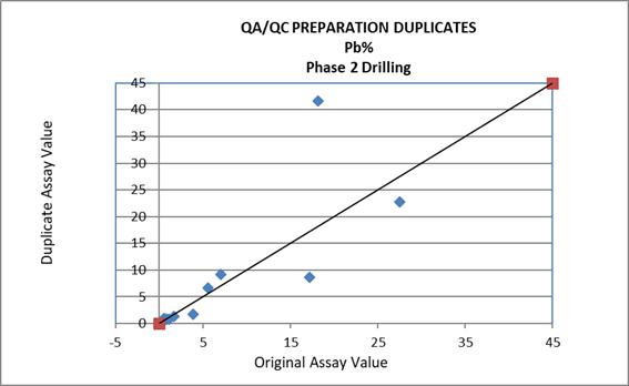
| Bunker Hill Mining Corp. | |
| Technical Report March 22, 2021 | Page 105 |

It is the opinion of the author that security of the samples remained uncompromised throughout the sampling program. Adequate sample preparation methods and QA/QC protocols are followed. Laboratories performed proper analyses on the samples, and the author has full confidence in the validity of the published results.
ALS Global testing laboratories are located at 4977 Energy Way, Reno NV 89502.
ALS has no relationship other than that of a vendor to BNKR.
| Bunker Hill Mining Corp. | |
| Technical Report March 22, 2021 | Page 106 |
The principal author, Mr. Wilson, has verified the data used in this Technical Report by:
| ● | Visiting the Project and confirming the geology and mineralization; | |
| ● | Visiting the core storage areas and inspecting the core cutting facility; | |
| ● | Reviewing drill core; | |
| ● | Verifying the location of drill holes; | |
| ● | Reviewing the QA/QC protocols; | |
| ● | And, reviewing the quality analysis of drilling and channel sampling data. |
The principal author, Mr. Wilson, concludes that:
| ● | Exploration drilling, drill hole surveys, sampling, sample preparation, assaying, and density measurements have been carried out in accordance with CIM Best Practice Guidelines and are suitable to verify the nature and extent of mineralization. | |
| ● | Sampling and assaying include sufficient quality assurance procedures | |
| ● | Exploration databases are professionally constructed and are sufficiently error free to support Mineral Resource estimates. |
The following sections describer verification procedures applied by the author. There were no limitations on the QP’s requirements for data verification. In the opinion of the principal author, such data is adequate and can be relied upon to verify Mineral Resources for the Project as described in this Technical Report.
12.1 Stope Block Validation
In order to gather data in areas inaccessible to drilling (specifically, historic stopes), BNKR implemented an underground sampling program under the strict guidance of the author. Beginning in March 2020, BNKR launched a significant underground sampling program with the intent of verifying historic assays and data located on the mine site. PMC, owner of the Bunker Hill Mine, granted access to the onsite historic data, as well as underground portions of the mine. Underground channel sample collection began on March 28, 2020. Over the following 3 months, a total of 753 samples were collected across ten levels and sub-levels of the mine. Underground sampling concluded on the June 24, 2020. The underground channel, or chip samples, in conjunction with diamond drilling described in Section 11, substantiated the well-documented mineralization of the historic mine.
12.1.1 Sampling Teams
Initially, two samplers began sampling using methods described below. Within three weeks, the sampling crew grew from two samplers to a team comprising a sample crew chief and six samplers. As the number of samplers increased, a geologist began to accompany samplers underground daily to perform sample layout, assist with the organized collection of samples and review the work performed.
12.1.2 Methodology
Collection of samples underground involved a multi-step process beginning with the identification of possible sample locations using historic maps. Targeted stopes fell within the boundaries of the UTZ, Newgard and Quill ore bodies. Scanned mylar maps provided excellent information about underground sample areas. Occasionally, the sample crew discovered an unmapped drift or finger. However, the maps proved to be roughly 95% accurate.
Upon arrival at a sampling location, the geologist began the orientation process by labeling mined out areas and designating each drift, finger, or pillar with a number using spray paint on the ribs. All such labeling was carefully recorded on field maps created from the mylar scans. In several sampling locations, room and pillar methods of mining left pillars that proved both useful in navigating large pillared “rooms” and simultaneously provided opportune sample locations. Once comfortably oriented, the geologist identified specific sampling locations on ribs (and where appropriate, on the back), where samples could be collected perpendicular to the bedding planes of the rock to accurately define the width of a mineralized interval. Inspection of the orientation of the bedding took place at every interval sampled.
| Bunker Hill Mining Corp. | |
| Technical Report March 22, 2021 | Page 107 |
While the geologist identified sampling locations within the designated area, samplers barred down loose rock and mitigated for a variety of potential safety hazards. Occasionally, historic mining clutter (pipes, old equipment, timber, etc.) blocked potential sample sites, necessitating its removal prior to sampling.
Sample layout commenced with the geologist and a sampler using a measuring tape reel and spray paint to indicate 5 ft. sample intervals. Vertical lines were painted 5’ apart on the ribs, and a single horizontal line connected the two, to indicate to the samplers where to perform the chip sampling (see Figure 12-1 below). Samples were laid out perpendicular to bedding in 5’ sections for as long as there was rock to sample. Prior to painting the ribs, the geologist assessed the stability/safety of each interval. Occasionally, poor ground conditions required skipping an interval where the possibility of rockfall existed. The sampling crew assessed the potentiality for back samples where gaps between the ribs existed. All sample intervals and footages were carefully recorded on field maps.
Initially, samplers approached the sample location with a tarp, a hand sledge and chisel, sample bag, aluminum sample ID tags and a sample tag book. Prior to sampling, the sampler recorded information regarding the sample location including the date, sampler, level and stope, finger/rib/pillar as designated by the geologist, sample interval footage, and rock/mineral description. The sampler wrote the sample ID number on the bag and inserted the paper tag from the sample tag book with the same sample ID into the bag.
Samplers carefully laid the tarp on the sill (floor) beneath the interval to be sampled. Chiseled rock chips removed from the rib or back would fall onto the tarp. Once a sampler removed the appropriate amount of material (between 1 and 10 lbs.) from the sample interval, the chips were collected from off the tarp and placed in the sample bag. The sampler placed the filled sample bag below the sample interval to be photographed and nailed an aluminum tag with the appropriate sample ID number on the right-hand side of the sample interval. Finally, the tarp was removed, cleaned to not cross-contaminate samples, and then moved on to the next sampling interval.
The sampling team quickly realized, however, that the hardness of the host rock (quartzite) significantly hindered the pace of sample collection. The team acquired two battery-operated, hand-held rock saws and, after the geologist performed sample layout, a sampler with the saw made two, 1-inch deep cuts in the rock roughly an inch apart, providing samplers a consistent edge to chisel easily along the entire sample interval. The rock saw significantly improved the rate of sample collection. And as the number of samplers and rate of sample collection increased, the crew chief, with assistance of the geologist, became responsible for preparing sample bags, recording the sample information, and photographing each interval to streamline the process.
| Bunker Hill Mining Corp. | |
| Technical Report March 22, 2021 | Page 108 |
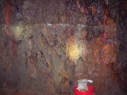
Figure 12-1 Rib sample collected from the 082-25-80 sublevel
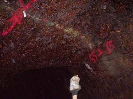
Figure 12-2 Back Sample collected from the 082-25-80 sublevel
At the end of a day of sampling, the sampling crew removed channel samples from the mine and transferred them to the core shed. As soon as the sampling crew accounted for each sample collected, standards and blanks were prepared and inserted in with the channel samples at a 1:20 interval for both standards and blanks.
After the samples were secured, the sample crew chief and geologist entered the data about each sample taken during the day’s sampling into an excel spreadsheet. Furthermore, they documented the precise location of each sample using georeferenced AutoCAD DWG files (see Figures 1-3 below) to generate a sample’s X, Y, and Z coordinates. Merging the sample’s physical location with the assay data proved useful in following mineralization trends and comparing current data to the historic results.

Figure 12-3 Sample locations on the 070-25-07 sublevel using geo-referenced AutoCAD files
| Bunker Hill Mining Corp. | |
| Technical Report March 22, 2021 | Page 109 |
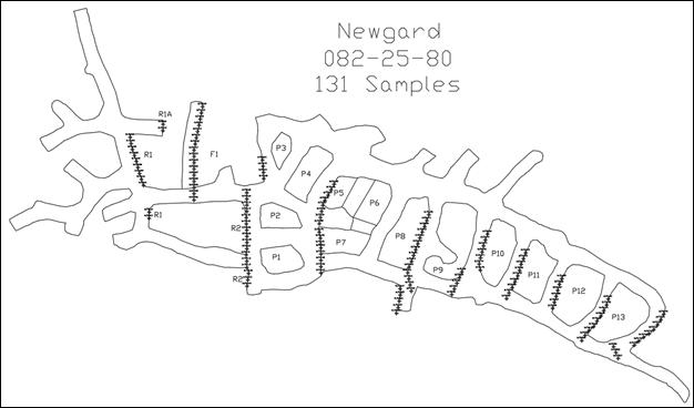
Figure 12-4 Sample locations on the 082-25-80 sublevel using geo-referenced AutoCAD files
| Bunker Hill Mining Corp. | |
| Technical Report March 22, 2021 | Page 110 |
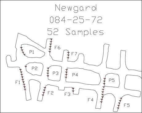
Figure 12-5 Sample locations on the 084-25-72 sublevel using geo-referenced AutoCAD files
| Bunker Hill Mining Corp. | |
| Technical Report March 22, 2021 | Page 111 |
A breakdown of sampled areas and the number of samples collected is shown in Table 12-1.
Table 12-1 Chanel Sample Breakdown
| Stopes Samples | Number of Samples | |
| UTZ | 111 | |
| 071-25-05 | 30 | |
| 070-25-07 | 86 | |
| 071-25-07 | 52 | |
| 082-25-80 | 131 | |
| 080-25-25 | 62 | |
| 080-25-23 | 101 | |
| 9 Level I-drift | 68 | |
| 10 Level | 70 | |
| 11 Level | 42 |
Throughout the underground sampling program, a number of safety and logistical constraints dictated sampling locations. The sampling crew navigated issues such as high backs, unstable or faulted ribs and pillars, poor air quality and gases, ground support, standing bodies of water, areas filled with waste rock, poor ground conditions, undetonated historic explosives, and gaping holes in the back or sill. Samplers frequently consulted with the mine safety manager and, where possible, found a way to safely collect samples. Occasionally, no viable solution to remedy safety issues required samplers to forego sampling in a desired location. Despite the obstacles, no safety incidents occurred during the 3 months of underground sampling.
| Bunker Hill Mining Corp. | |
| Technical Report March 22, 2021 | Page 112 |
13 Mineral Processing and Metallurgical Testing
No mineral processing or metallurgical testing has been performed or carried out.
| Bunker Hill Mining Corp. | |
| Technical Report March 22, 2021 | Page 113 |
14.1 Summary
Mineral Resource Estimates in this report have been updated by using modern grade estimation techniques for the Quill, Newgard and UTZ mineralization bodies. Mineral assays were derived from the current BNKR drilling program, historic drilling which was verified in September 2020, historic production car samples and channel samples gathered during the summer of 2020. Mineral Resource Estimates have been determined with care according to the CIM Estimation of Mineral Resources and Mineral Reserves Best Practice Guidelines. As a US mining operation for nearly one hundred years, there have been historic reserve estimates calculated at Bunker. This Technical Report represents the first estimate of mineral resources for the UTZ zone. Mineral Resources have been reported in accordance with the disclosure obligations under NI 43-101.
Mineral Resources for the Project are reported as lead silver (“PbAg”) resources and zinc-silver (“ZnAg”) resources. Mineralized material, meeting the reasonable prospects for eventual economic extraction, is assumed to be initially run through a mill. However, subsequent processes would be required to extract metal based upon separate lead and zinc flotation processes. Mineral resources are estimated at a cutoff of 3.3% Pb and 3.3 % Zn. Silver is assumed to be a byproduct.
Project mineralization extends to great depths accessible by a complicated system of shafts to access levels and mine workings. Not all historic workings have been recorded on plan maps. The mine is flooded up to the 11 Level of the mine. Other than pumping water according to EPA requirements, and limited care and maintenance, access to the depths of the mine has not been accessible since 1989. For these reasons, many parts of the mineral resource are considered to be inferred mineral resources. In September 2020 RDA recommended that Bunker needed to modernize the mineral resource estimate including the use of geology in the estimation of Pb, Ag and Zn mineralization. Modernization in this context dictated the creation of a complete digital model using modern mineral estimation techniques. RDA has completed that recommendation, bringing portions of Quill, Newgard, UTZ and Homestake mineral bodies into the inferred mineral resource classification.
Mineral Resources are not Mineral Reserves and do not have demonstrated economic viability. There is no certainty that all or any part the Mineral Resources will be converted to Mineral Reserves.
Table 14-1 summarizes the Bunker Hill Indicated Mineral Resource estimate, classified according to CIM definitions for the Project. Reasonable prospects of eventual economic extraction, defined in this section of the report, assume underground mining, and mill processing and flotation of PbAg mineralization and ZnAg mineralization as polymetallic mines typically require separate Pb flotation and Zn flotation circuits. All estimated blocks meet the Zinc and Lead cutoff grades of 3.3%.
Table 14-1 Bunker Hill Mine Indicated Mineral Resources at Zinc Selling Price of USD $1.00 per Pound, Pb Selling Price of $0.80 Per Pound and Silver Selling Price of $23 Per Ounce (Effective date March 22, 2021)
| Indicated Mineral Resources | Tonnes (x1,000) | Pb % | Pb Lbs. (x1,000) | Ag Oz/Ton | Ag Ounces (x1,000) | Zn % | Zn Lbs. (x1,000) | |||||||||||||||||||||
| ZnAg Indicated Mineral Resources | 4,410 | 2.00 | 176,771 | 0.69 | 3,033 | 5.52 | 487,185 | |||||||||||||||||||||
Mineral Resources are not Mineral Reserves and do not have demonstrated economic viability. There is no certainty that all or any part of the Mineral Resources will be converted into Mineral Reserves. Numbers may not add up due to rounding. RDA knows of no environmental, permitting, legal, title, taxation, socio-economic, marketing, political, or other relevant factors that may materially affect the Mineral Resource estimate in this Technical Report. The Qualified Person for the Mineral Resource Estimate is Scott Wilson.
Table 14-2 summarizes the Bunker Hill Inferred Mineral Resource estimate, classified according to CIM definitions for the Project. Reasonable prospects of eventual economic extraction, defined in this section of the report, assume underground mining, and mill processing and flotation of PbAg mineralization and ZnAg mineralization as polymetallic mines typically require separate Pb flotation and Zn flotation circuits. All estimated blocks meet the Zinc and Lead cutoff grades of 3.3%.
| Bunker Hill Mining Corp. | |
| Technical Report March 22, 2021 | Page 114 |
Table 14-2 Bunker Hill Mine Inferred Mineral Resources at Zinc Selling Price of USD $1.00 per Pound, Pb Selling Price of $0.80 Per Pound and Silver Selling Price of $23 Per Ounce (Effective date March 22, 2021)
| Inferred Mineral Resources | Tonnes (x1,000) | Pb % | Pb Lbs. (x1,000) | Ag Oz/Ton | Ag Ounces (x1,000) | Zn % | Zn Lbs. (x1,000) | |||||||||||||||||||||
| PbAg Inferred Mineral Resources | 1,050 | 7.56 | 158,815 | 4.28 | 4,497 | 1.50 | 31,419 | |||||||||||||||||||||
| ZnAg Inferred Mineral Resources | 4,569 | 1.67 | 152,878 | 0.83 | 3,796 | 5.66 | 517,403 | |||||||||||||||||||||
| Bunker Hill Total Inferred Mineral Resources | 5,618 | 2.77 | 311,693 | 1.48 | 8,294 | 4.88 | 548,821 | |||||||||||||||||||||
Mineral Resources are not Mineral Reserves and do not have demonstrated economic viability. There is no certainty that all or any part of the Mineral Resources will be converted into Mineral Reserves. Numbers may not add up due to rounding.
14.2 Mineral Resource Model
Mineral estimates for Newgard, Quill and UTZ are based on 41 core holes drilled by Bunker in 2020 and 2021. The channel sampling and data verification program of 2020 added an additional 394 individual channel samples. Bunker Hill’s recent drilling and sampling campaigns were successful in validating historical information as being accurate and useable for mineral resource estimates. Two hundred twenty (220) historic drillholes and 4,525 production car samples were used in the estimation of the resource; as recommended by RDA in September 2020.
Mineralization was estimated using inverse distance to the third power (ID3) techniques. Because much of the data is clustered, declustering statistics were used in the estimation to reduce the impact of locally sampled high-grade mineralization. Grade capping was evaluated to ensure that grades are not skewed high due to a small number of extremely high grade, non-representative samples.
New mineral resource estimates have been determined for the UTZ, Newgard and Quill mineral bodies. All other resource estimates remain unchanged from the September 2020 estimate. Figure 14-1 displays the mined-out portions of the updated mineralization and provides a reference for the recently estimated portions of the deposit.
| Bunker Hill Mining Corp. | |
| Technical Report March 22, 2021 | Page 115 |
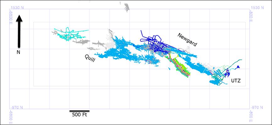
Figure 14-1 Quill, Newgard and UTZ deposits of the Bunker Hill Mine. Mineral resources between levels and within pillars have been updated for this report.
Most recent mining at Bunker hill ceased in 1991. The stopes and workings displayed above have were surveyed during production and drafted onto mylar sheets. The Mylar sheets were recently digitized by Rangefront and converted to solid triangulations. In general mineralization strikes S070E with a nearly vertical dip.
| Bunker Hill Mining Corp. | |
| Technical Report March 22, 2021 | Page 116 |
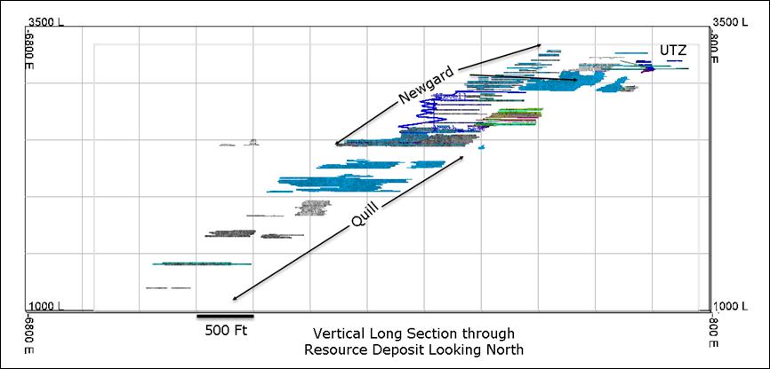
Figure 14-2 Vertical long section through the deposit showing currently mined out stopes down-dip and mineralized pillars between stopes.
Nearly 2,500 vertical feet of continuous mineralization is present in UTZ, Newgard and Quill deposits. All areas between the existing stopes have been estimated using a block model and ID3 estimation techniques. A resource constraining shell (Figure 14-3) has been explicitly designed around known mineralization and used as a limit to resource estimates for the Project. Continued exploration drilling and geological modelling is required to expand mineralization.
| Bunker Hill Mining Corp. | |
| Technical Report March 22, 2021 | Page 117 |

Figure 14-3. Interpretation of mineral envelope based on drilling, mining, and sampling of the deposit.
| Bunker Hill Mining Corp. | |
| Technical Report March 22, 2021 | Page 118 |

Figure 14-4. Long Section through Drilling used to Support the Mineral Estimate.
| Bunker Hill Mining Corp. | |
| Technical Report March 22, 2021 | Page 119 |
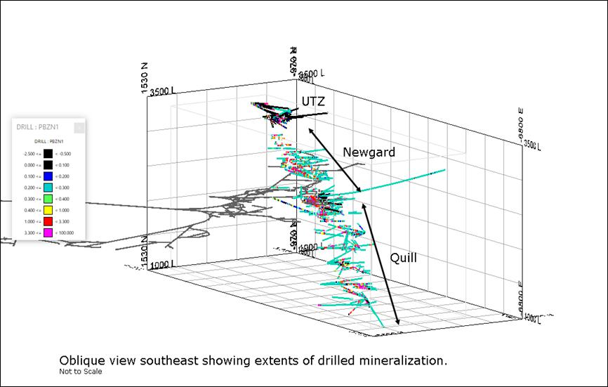
Figure 14-5. Oblique view through Drilled Mineralization for the Updated Estimate.
| Bunker Hill Mining Corp. | |
| Technical Report March 22, 2021 | Page 120 |
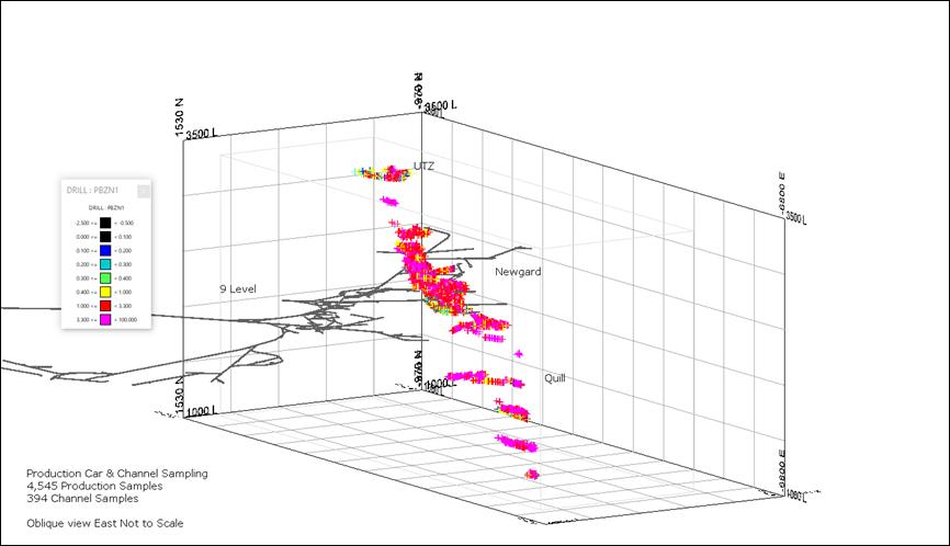
Figure 14-6 Channel Sampling and Production Car Sampling use to Support the Mineral Estimate.
| Bunker Hill Mining Corp. | |
| Technical Report March 22, 2021 | Page 121 |

Figure 14-7. Channel Samples, Production Car Samples and Drilling Composites used for the Mineral Resource Estimate
| Bunker Hill Mining Corp. | |
| Technical Report March 22, 2021 | Page 122 |

Figure 14-8 Estimated Mineralization at the Zn Cutoff grade of 3.3%
| Bunker Hill Mining Corp. | |
| Technical Report March 22, 2021 | Page 123 |

Figure 14-9 Classified Mineralization for UTZ, Quill and Newgard Deposits
| Bunker Hill Mining Corp. | |
| Technical Report March 22, 2021 | Page 124 |
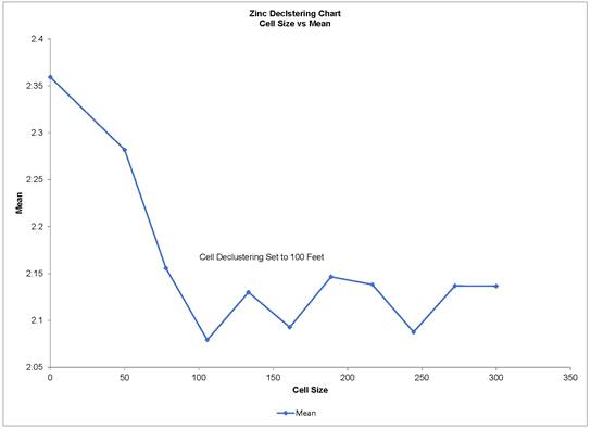
Figure 14-10 Cell Declustering used for Zinc and Lead Estimates
PbAg Inferred Mineral Resource estimates are reported in Table 14-3. ZnAg Inferred Mineral Resources estimates are reported in Table 14-4. The total Indicated Resource is reported in Table 14.5. Tonnages are rounded to reflect that these are estimated tonnages and grades. Totals may not add up due to rounding.
Table 14-3 Bunker Hill Mine Inferred PbAg Mineral Resource (Effective Date March 22, 2021)
| Mineral Body | Tons | Pb% | Ag Oz/Ton | Zn% | ||||||||||||
| Jersey A | 12,000 | 6.85 | 4.69 | 0.41 | ||||||||||||
| Jersey B | 11,000 | 5.00 | 2.59 | 0.61 | ||||||||||||
| Henry | 25,000 | 9.67 | 6.58 | 2.11 | ||||||||||||
| New Landers A | 52,000 | 2.99 | 1.45 | 4.33 | ||||||||||||
| New Landers B | 29,000 | 9.42 | 4.83 | 0.93 | ||||||||||||
| Atkins | 27,000 | 14.23 | 6.94 | 0.86 | ||||||||||||
| Shea | 117,000 | 5.36 | 3.91 | 2.73 | ||||||||||||
| Barr | 2,000 | 13.70 | 5.30 | 0.80 | ||||||||||||
| Francis | 83,000 | 6.04 | 3.03 | 1.93 | ||||||||||||
| Francis Footwall | 330,000 | 8.91 | 4.08 | 1.49 | ||||||||||||
| Mac | 88,000 | 7.60 | 3.39 | 1.04 | ||||||||||||
| J Vein | 273,000 | 7.23 | 5.40 | 0.61 | ||||||||||||
| Total Inferred PbAg Resource | 1,050,000 | 7.56 | 4.28 | 1.50 | ||||||||||||
| Bunker Hill Mining Corp. | |
| Technical Report March 22, 2021 | Page 125 |
Mineral Resources are not Mineral Reserves and do not have demonstrated economic viability. There is no certainty that all or any part the Mineral Resources will be converted to Mineral Reserves.
Table 14-4 Bunker Hill Mine Inferred ZnAg Mineral Resource (Effective Date March22, 2021)
| Mineral Body | Tons | Pb% | Ag Oz/Ton | Zn% | ||||||||||||
| Newgard + Quill | 2,066,000 | 1.90 | 0.66 | 5.25 | ||||||||||||
| UTZ + Homestake | 54,000 | 1.76 | 0.61 | 4.79 | ||||||||||||
| Rosco | 777,000 | 1.19 | 0.83 | 5.18 | ||||||||||||
| Orr | 70,000 | 1.24 | 0.65 | 6.14 | ||||||||||||
| Brown | 475,000 | 1.89 | 1.34 | 7.33 | ||||||||||||
| Roger | 115,000 | 1.31 | 0.91 | 5.27 | ||||||||||||
| South Tallon | 486,000 | 1.15 | 0.69 | 5.49 | ||||||||||||
| Tallon | 283,000 | 1.77 | 1.21 | 5.37 | ||||||||||||
| Tony-Cate | 110,000 | 1.93 | 1.02 | 5.72 | ||||||||||||
| Steve | 134,000 | 2.14 | 1.26 | 10.59 | ||||||||||||
| Total Inferred ZnAg Resource | 4,570,000 | 1.67 | 0.83 | 5.66 | ||||||||||||
Mineral Resources are not Mineral Reserves and do not have demonstrated economic viability. There is no certainty all or any part the Mineral Resources will be converted to Mineral Reserves.
One of the RDA conclusions from the September 2020 Technical Report was that modern grade estimation practices can duplicate the September Mineral Resource statement. Using ID3 grade estimation techniques along with grade capping, as well as sample declustering worked well for the project. This increased confidence in the distribution of grades has allowed for a portion of the deposit to be considered as Indicated Mineral Resources which are disclosed in Table 14-5.
Table 14-5 Bunker Hill Mine Indicated ZnAg Mineral Resource (Effective Date March22, 2021)
| Mineral Body | Tons | Pb% | Ag Oz/Ton | Zn% | ||||||||||||
| Newgard + Quill | 4,523,000 | 1.99 | 0.069 | 5.54 | ||||||||||||
| UTZ + Homestake | 157,000 | 2.39 | 0.62 | 5.07 | ||||||||||||
| Total Indicated ZnAg Resource | 4,410,000 | 2.00 | 0.69 | 5.52 | ||||||||||||
Numerous factors such as commodity price fluctuations, property tenure, environmental and permitting issues, metallurgical and geotechnical considerations may have a material impact on the Bunker Hill Project.
| Bunker Hill Mining Corp. | |
| Technical Report March 22, 2021 | Page 126 |
There are no mineral reserves estimated for the Project.
| Bunker Hill Mining Corp. | |
| Technical Report March 22, 2021 | Page 127 |
This section is not applicable to this Technical Report.
| Bunker Hill Mining Corp. | |
| Technical Report March 22, 2021 | Page 128 |
This section is not applicable to this Technical Report.
| Bunker Hill Mining Corp. | |
| Technical Report March 22, 2021 | Page 129 |
This section is not applicable to this Technical Report.
| Bunker Hill Mining Corp. | |
| Technical Report March 22, 2021 | Page 130 |
19 MArket Studies and COntracts
This section is not applicable to this Technical Report.
| Bunker Hill Mining Corp. | |
| Technical Report March 22, 2021 | Page 131 |
20 EnvirOnmental Studies, PErmitting and Social or Community IMpact
This section is not applicable to this Technical Report.
| Bunker Hill Mining Corp. | |
| Technical Report March 22, 2021 | Page 132 |
21 Capital and Operating COsts
This section is not applicable to this Technical Report.
| Bunker Hill Mining Corp. | |
| Technical Report March 22, 2021 | Page 133 |
This section is not applicable to this Technical Report.
| Bunker Hill Mining Corp. | |
| Technical Report March 22, 2021 | Page 134 |
Adjacent properties are properties in which the issuer does not have an interest, has a boundary that is proximate to the Property being reported upon and has similar geological characteristics to the Property being reported on. Figure 16.1 shows the adjacent properties contiguous to the Bunker Hill Property.

The mineralized veins of the Crescent Silver Project are located approximately 1.25 miles (2 km) east-southeast of the past-producing Bunker Hill Mine (Figure 23.2). Crescent Silver Project mineral tenure consists of 1,280 acres (518 ha) of patented mining claims and is contiguous with the Bunker Hill Property.
The following information on the Crescent Silver Project has been taken from the Crescent Silver LLC. website. The Resource Estimate shown in Table 23.1 was summarized from the 2013 NI 43-101 Technical Report and Preliminary Economic Assessment by Pennington and Hartley.
The qualified person has been unable to verify the information within the Crescent Silver technical report. The information is not necessarily indicative of the mineralization at Bunker which is the subject of this technical report.
The Crescent Silver Project (Pennington and Hartley 2013) currently contains four known major mineralized zones. The mineralized veins of the Crescent Silver Project are typical “Silver Belt” veins, and are composed of siderite, quartz, and various sulfides including pyrite, tetrahedrite, chalcopyrite, arsenopyrite and galena.
| Bunker Hill Mining Corp. | |
| Technical Report March 22, 2021 | Page 135 |
Table 23-1 Crescent Silver Project Mineral Resource
| Silver | Copper | |||||||||||||||||||||
| Vein | Resource Class | Tons (x 1,000) | oz/ton | oz (x 1,000) | % | lb (x1,000) | ||||||||||||||||
| Alhambra | Measured | 8.2 | 18.4 | 150 | 0.32 | 52 | ||||||||||||||||
| Indicated | 101.4 | 15.5 | 1,568 | 0.24 | 485 | |||||||||||||||||
| Measured + Indicated | 109.6 | 15.7 | 1,718 | 0.25 | 538 | |||||||||||||||||
| Inferred | 442.4 | 14.0 | 6,189 | 0.19 | 1,709 | |||||||||||||||||
| Jackson | Measured | 2.8 | 19.6 | 54 | 0.87 | 48 | ||||||||||||||||
| Indicated | 1.4 | 18.8 | 26 | 0.80 | 22 | |||||||||||||||||
| Measured + Indicated | 4.1 | 19.3 | 80 | 0.85 | 70 | |||||||||||||||||
| Inferred | 15.3 | 16.3 | 248 | 0.82 | 250 | |||||||||||||||||
| South | Measured | 27.8 | 23.3 | 647 | 0.61 | 342 | ||||||||||||||||
| Indicated | 59.3 | 23.4 | 1,387 | 0.57 | 681 | |||||||||||||||||
| Measured + Indicated | 87.1 | 23.4 | 2,035 | 0.59 | 1,023 | |||||||||||||||||
| Inferred | 526.8 | 24.1 | 12,670 | 0.63 | 6,602 | |||||||||||||||||
| Total | Measured | 38.7 | 22.0 | 851 | 0.57 | 443 | ||||||||||||||||
| Indicated | 162.1 | 18.4 | 2,981 | 0.37 | 1,189 | |||||||||||||||||
| Measured + Indicated | 200.8 | 19.1 | 3,833 | 0.41 | 1,631 | |||||||||||||||||
| Inferred | 948.5 | 19.4 | 19,107 | 0.43 | 8,561 | |||||||||||||||||
The reader is cautioned that the above information is not necessarily indicative of the mineralization on the Bunker Hill Property.
The past-producing Sunshine Mine is located approximately 4 km east-southeast of the Bunker Hill Property. The Sunshine Mine Project mineral tenure consists of 10,377 acres (4,200 ha) of patented and unpatented mining claims and is contiguous with the Bunker Hill Property.
The information presented here has been summarized from the NI 43-101 Technical Report, Resource Estimate and Preliminary Economic Assessment prepared for Sunshine Silver Mines Corporation by TetraTech and MTB (Bryan et al. 2014). The data contained in the technical report and website has not been originally sourced or verified by RDA.
Table 23-2 Sunshine Mine Mineral Resource Estimate
| Sunshine Mine Resource Estimate, 2014 | ||||||||||||||||||||||||
Resource Class | Tons Diluted | Ag Grade Diluted (g/t) | Ag Contained Ounces | Cu % | Pb % | Zn % | ||||||||||||||||||
| Measured | 1,120,000 | 843 | 30,300,000 | - | - | - | ||||||||||||||||||
| Indicated | 1,870,000 | 752 | 45,200,000 | - | - | - | ||||||||||||||||||
| Measured + Indicated | 2,980,000 | 786 | 75,500,000 | - | - | - | ||||||||||||||||||
| Inferred | 8,170,000 | 842 | 221,300,000 | 0.22 | 0.35 | 0.02 | ||||||||||||||||||
24 Other Relevant Data and Information
The Author knows of no other relevant data and information that would make the report understandable and not misleading.
| Bunker Hill Mining Corp. | |
| Technical Report March 22, 2021 | Page 136 |
25 Interpretations and Conclusions
The Bunker Hill Mine is one of the most historic base metal and silver mines in American history. Initial discovery and development of the property began in 1885, and from that time until the mine closed in 1981 it produced over 35.8 M tons (32.5 M tonnes) of mineralization at an average mined grade of 8.76% lead, 4.52 ounces per ton (155 g/t) silver, and 3.67% zinc. The acquisition of the Bunker Hill Mine Project includes existing infrastructure at Milo Gulch, and the majority of machinery and buildings at the Kellogg Tunnel portal level as well as all equipment and infrastructure anywhere underground at the Bunker Hill Mine Complex.
The mineralization of the Coeur d’Alene district consists of veins with variable proportions of sphalerite, galena, argentiferous tetrahedrite in either a quartz or siderite gangue. Most silver production has come from the mineral belt south of the Osburn Fault, the western part of which includes the Bunker Hill Mine and is known as the Silver Belt. The deposits are numerous and relatively large with strike lengths up to 984 ft (300 m) with dip lengths of over 3,280 ft (1,000 m). Wall rock alteration associated with veining consists of changes in carbonate mineralogy plus sulfidation and silicification. Pyritization of wall rocks is locally strong. Bleached halos resulting from destruction of hematite by hydrothermal fluids are also characteristic. The mineralization is partly oxidized to a depth of approximately 1,968 ft (600 m).
The Bunker Hill Mine comprises multiple zones of mineralization. Most production has come from structurally controlled zones along the northwest striking and southwest dipping Cate Fault, a splay structure of the Osburn Fault. Mineralization is primarily hosted by quartzites and siltites of the Revett and St. Regis Formations of the Ravalli Group. Mineralization occurs in veins in the footwall rocks of the Cate Fault, and from veins and stratabound mineralization in the hanging wall of the Cate Fault.
RDA is of the opinion that the past production of over 160 million ounces of silver should be investigated with vigorous exploration programs. While base metals are a very important component of the Project, the recent selling prices of silver demand attention. The confirmation drilling program identified intercepts of 10 to 20 ounces per ton of sliver. The J vein and Francis stopes hosted high grade silver mineralization. The near surface historic Caledonia and Sierra Nevada Mines were bonanza grade silver producers in the past. These and other known occurrences of silver must be followed up upon to determine if economic silver occurrences exist on the Bunker Hill Property land package.
Drilling and sampling programs confirmed the mineral resources for the project. These factors resulted in a portion of the historic reserve estimate being considered a current mineral resource estimate.
This Technical Report is based on all available technical and scientific data available as of September 29, 2020. Mineral Resources are considered by the QP to meet the reasonable prospects of eventual economic extraction due two main factors; 1) cutoff grades are based on scientific data and assumptions related to the project and 2) Mineral Resources are estimated only within blocks of mineralization that have been accessible in the past by mining operations as well as by using generally accepted mining and processing costs that are similar to many projects in Idaho.
The exploration and development of mineral properties involves risk. There can be no assurance that the exploration program discussed in this Technical Report will result in additional Mineral Resource Estimates. Numerous factors such as commodity price fluctuations, property tenure, environmental and permitting issues, metallurgical and geotechnical considerations may have a material impact on the Bunker Hill Project.
| Bunker Hill Mining Corp. | |
| Technical Report March 22, 2021 | Page 137 |
Exploration programs should focus on the definition of silver resources. Silver resources that have the reasonable prospects of eventual economic extraction have been identified within the current mineral resource estimate. Significant silver mineralization encountered through exploration and past production suggests that these zones should be given as much weight as past Pb and Zn exploration and resource definition programs.
There is sparse information available on the metallurgical characteristic of mineralization at the project. Obviously, historic production from two smelters suggests that metallurgy was understood or even assumed. Modern projects must understand metallurgy in order to begin the process of economic evaluations for the project. Metallurgical samples need to be collected for bluebird mineralization and quartz-galena mineralization as a starting point.
Digitization of nearly 100 years of paper maps is in progress and should be completed. In addition to unlocking the understanding of the geometry of the mineral deposit much of the information describes the mined-out portion of the Project. This will be critical for future mineral resource estimates as mined out voids need to be accounted for.
Table 26-1 Proposed Phase 1 Work Program to Advance Bunker Hill
| Activity | Amount | |||
| Drilling Program focusing on Silver (includes labor and assaying) | $ | 2.10M | ||
| Metallurgical definition characteristics of Bluebird and Quartz-Galena Mineralization | $ | 0.20M | ||
| Digital compilation of historical information | $ | 0.75M | ||
| Environmental Studies as part of care and maintenance | $ | 0.80M | ||
| Rehabilitation and Infrastructure Improvements in Support of Drilling | $ | 1.30M | ||
| Total | $ | 5.15M | ||
RDA has not recommended successive phases of work for the advancement of the Project.
| Bunker Hill Mining Corp. | |
| Technical Report March 22, 2021 | Page 138 |
Farmin, J., 1977. Geologic Research Progress Summary and 1977 Exploration Plans, Bunker Hill Mining internal memo.
Herndon, Stephen D., “Diagenesis and metamorphism in the Revett quartzite (Middle Proterozoic Belt) Idaho and Montana” (1983). Graduate Student Theses, Dissertations, & Professional Papers. 7510.
Hobbs, S. W., A. B. Griggs, R. E. Wallace, and A. B. Campbell, 1965, Geology of the Coeur d’Alene district, Shoshone Co., Idaho: U.S. Geological Survey Professional Paper 478, 139 p.
Idaho Geologic Survey, 2002. Geologic Map of Shoshone County, Open-File Publication. https://www.idahogeology.org/webmap.
Juras, D. S., 1977, Structural Geology of Bunker Hill Mine: Private report for the Bunker Hill Company, 111 p.
Juras, D. and Duff, J., 2020. Geology and Ore Controls at the Bunker Hill Mine, Coeur d’Alene District, Idaho: Private report for the Bunker Hill Company.
Leach, D.L., Hofstra, A.H., Church, S.E., Snee, L.W., Vaughn, R.B., and Zartman, R.E., 1998, Evidence for Proterozoic and Late Cretaceous-Early Tertiary ore-forming events in the Coeur d’Alene district, Idaho and Montana: Economic Geology, v. 93, p. 347-359.
Lydon, J.W., 2007, Geology and metallogeny of the Belt-Purcell Basin, in Goodfellow, W.D., ed., Mineral Deposits of Canada: A Synthesis of Major Deposit Types, District Metallogeny, the Evolution of Geological Provinces, and Exploration Methods: Geological Association of Canada, Mineral Deposits Division, Special Publication No. 5, p. 581-607.
Meyer, R. L. and Springer, D., 1985, Proposal to Explore and Mine the Bunker Hill Property, Shoshone County, Idaho, Private report for Bunker Limited Partnership.
White, B. G., 1976, Revett stratigraphy of the Bunker Hill mine and vicinity: Private report prepared for The Bunker Hill Co., Dec. 31, 1976, 46 p., 4 plates.
White, B.G., 1994, Shear zone hosted ore deposits of the Coeur d’Alene mining district, Idaho, USA: Geological Society of America Abstracts with Program, v. 26, no.7, p.21.
White, B. G., and D. S. Juras, 1976, Surface geological map, and cross Sections of the Bunker Hill property: Private report for The Bunker Hill Co., December. 1976.
White, B., 2015. “New Concepts for the Exploration of the Bunker Hill Mine: 2015”: Private Report for New Bunker Hill Mining Company.
Wilson, S.E., 2020, “Technical Report for the Bunker Hill Mine, Coeur d’Alene Mining District, Shoshone County, Idaho, USA.”
Serious News for Serious Traders! Try StreetInsider.com Premium Free!
You May Also Be Interested In
- Ben Lang on Notion, Building a Community, and the Art of Angel Investing
- Danfoss Selects RISE with SAP and HPE GreenLake to Accelerate Sustainable Cloud Journey
- Affimed Announces Acceptance of AFM24 Clinical Abstract at the 2024 Annual Meeting of the American Society of Clinical Oncology
Create E-mail Alert Related Categories
SEC FilingsSign up for StreetInsider Free!
Receive full access to all new and archived articles, unlimited portfolio tracking, e-mail alerts, custom newswires and RSS feeds - and more!