Solstice Significantly Expands Red Lake RLX Claim Position
 Tweet
Tweet Share
ShareGet Alerts SGC Hot Sheet
Overall Analyst Rating:
BUY (= Flat)
Dividend Yield: 4%
Revenue Growth %: +3.5%
Join SI Premium – FREE
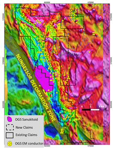
-additional support confirming setting near major regional structure-
VANCOUVER, British Columbia, March 16, 2021 (GLOBE NEWSWIRE) -- Solstice Gold Corporation (TSXV: SGC) (“Solstice”, the “Company”, “we” or “our”) is pleased to announce that we have acquired through staking an additional 2,234 Ha (111 claim units) to cover additional inferred target areas. The RLX property now covers a total of 5,534 Ha (275 claim units) over an area of greenstone which contains extensive electromagnetic (“EM”) conductors which are essentially restricted to the RLX claim group.
The Company has also located additional third-party geological information that confirms that the RLX project is positioned near a major regional structure. Such structures are known to be important in the formation of significant gold mineralization in the Red Lake Camp and in other gold camps across Canada. Recently, the Ontario Geological Survey (OGS)1 drew attention to previous seismic data which they suggested could be used to identify a possible third major structure in the district, the other two being interpreted by the OGS to generally correlate with the location of major gold mineralization and deposits in the Red Lake camp. It follows that if another major structure exists, it could potentially host new Red-Lake type mineralization.
While the OGS interpretation of seismic data is compelling, additional independent data exist in government files which support the presence of a major structure in the area, which are summarized below and in Figure 1.
1) OGS magnetic data (2008)2 allow identification of clear crustal scale features. Well-developed linear magnetic features, which are related to regional faults can easily be discerned using OGS airborne magnetic survey data (see Solstice NR dated February 2, 2021, for a regional magnetic map and also our corporate presentation at https://www.solsticegold.com/investors/presentations/).
2) OGS mapping in 19983 identified a major regional structure. The Nungessor Deformation Zone is a major fault zone (mylonite) which is mapped parallel to, and on the west flank of, the RLX property (Figure 1)
3) A specific rock type, formed at depth and associated with major crustal faults, has been mapped on the property boundary by the OGS4. This rock type, called sanukitoid, was sampled and confirmed in 2000 by the OGS. These rocks are documented from the Archean worldwide. Their significance is that they are formed, in part, from melting of the mantle i.e. very deep in the earth, and as documented elsewhere “their very presence in outcrop identifies a translithospheric structure”5 Although no age data are available for the Nungessor sanukitoid, other similar rock types regionally are dated around the same age as the major gold mineralization event in the district.
Taken together, the presence of a mapped major fault and the documentation of specific intrusive rocks which are themselves diagnostic of major crustal features both support, and are mutually independent of, the recent OGS interpretation based solely on seismic data.
“It is well documented that major gold deposits in the Archean of Canada and elsewhere occur close to major structures or breaks. These structures have potential to tap deep into the earth to source potential metals, including gold, and to create the higher-level conditions required to deposit or trap these metals. It is clear from third-party data that our RLX project sits close to one such major structure. We interpret RLX to be in a setting similar to the Sidace Gold Deposit clams (Paction/Evolution Mining), 11km to the south which also contain similar, extensive EM conductors. We have just completed a detailed 50m-spaced magnetic survey and are re-evaluating the EM data through a third-party consultant. We are also developing plans, again using an expert third-party consultant to employ soil and/or biogeochemistry surveys over the anomalies. Following this, we plan to employ boots on the ground to upgrade map-based geological data. Results of these programs will lead to the generation of targets for drill follow up late in 2021 or early 2022,” stated Chairman David Adamson. During his successful 16 years of exploration in the Red Lake camp, David Adamson was a co-award winner for the discovery of Battle North Gold Corporation's Bateman Gold deposit6 and was instrumental in the acquisition of many of the Red Lake district properties in the Battle North portfolio.
Figure 1: RLX Structural Setting:https://www.globenewswire.com/NewsRoom/AttachmentNg/f4918944-b0d1-4fc1-ac22-c305c011745e
Additional details regarding the RLX Project are available in the Company’s news release dated February 4, 2021 and in the updated presentation on the Company’s website at www.solsticegold.com.
About Solstice
Solstice is a gold-focussed exploration company engaged in the exploration of our high-quality exploration assets in top tier jurisdictions. Our 33 km² Red Lake Extension project is located on the north end of the prolific Red Lake Gold District. Our district scale KGP project covers 886 km² with certain other rights covering an adjacent 683 km², all with no underlying option or earn in payments. KGP has seen over $12MM dollars spent on significant field work, identified a 10 km² gold boulder field and now prepared with multiple drill ready targets. KGP is located in Nunavut, Canada only 26 km from Rankin Inlet and approximately 7 km from the Meliadine gold deposits owned by Agnico Eagle Mines Ltd. Solstice has 99.8 million shares outstanding.
Solstice is committed to responsible exploration and development in the communities in which we work. For more details on Solstice Gold, the Red Lake Extension Project and the KGP Project, please see our Corporate Presentation available at www.solsticegold.com.
Neither TSX Venture Exchange nor its Regulation Services Provider (as that term is defined in the policies of the TSX Venture Exchange) accepts responsibility for the adequacy or accuracy of this release.
Sandy Barham, M.Sc., P.Geo., Senior Geologist, is the Qualified Person as defined by NI 43-101 standards responsible for reviewing and approving the technical content of this news release.
1 https://www.mndm.gov.on.ca/sites/default/files/recommendations_for_exploration_2020-2021.pdf
MNDM Interpretation from: Lewis, S.O. 2021. Deep tapping seismic structure in the Red Lake district; in Ontario Geological Survey, Resident Geologist Program, Recommendations for Exploration 2020-2021, p.9-13.
Original Seismic Interpretation from:
Zeng, Fafu and Calvert, Andrew. 2011. Imaging the upper part of the Red Lake greenstone belt, northwestern Ontario, with 3-D traveltime tomography. Canadian Journal of Earth Sciences, v.43. p.849-863. https://doi.o rg/10.1139/e06-027.
2 Ontario Geological Survey 2008. Ontario airborne geophysical surveys, magnetic and electromagnetic data, grid and profile data (ASCII and Geosoft formats) and vector data, Whitefeather forest area, GEOTEM 1000 survey, Ontario Geological Survey, Geophysical Data Set 1058a.
3 OGS: Stone D. 1998. Precambrian geology, Trout Lake area; Ontario Geological Survey, Map P.3383. scale 1:250 000
4 Lichtblau, A., Raoul, A., Ravnaas, C., Storey, C.C., Kosloski, L., Debicki, R. and Drost, A. 2001. Report of Activities 2000, Resident Geologist Program, Red Lake Regional Resident Geologist Report: Red Lake and Kenora Districts; Ontario Geological Survey, Open File Report 6047, 109p.
5 Smithies, RH, Lu, Y, Kirkland, CL, Cassidy, KF, Champion, DC, Sapkota, J, De Paoli, M and Burley, L 2018, A new look at lamprophyres and sanukitoids, and their relationship to the Black Flag Group and gold prospectivity: Geological Survey of Western Australia, Record 2018/15, 23p
6 Battle North Gold Bateman Gold Project, current Feasibility Study includes resources of M&I 985,400 oz Au @ 6.04gpt and Inf 272,200 oz Au @ 6.5gpt
This news release contains references to other projects, their structures and mineralization, there is no certainty that Solstice’s projects will contain similar structures or mineralization.
On Behalf of Solstice Gold Corp.
David Adamson, PhDChairman
For further information please visit our website at www.solsticegold.com or contact:
Marty Tunney, PEngPresident[email protected]
Forward Looking Statements
This news release contains certain forward-looking statements (“FLS”) relating but not limited to the Company’s expectations, intentions, plans and beliefs. FLS can often be identified by forward-looking words such as “approximate or (~)”, “emerging”, “goal”, “plan”, “intent”, “estimate”, “expects”, “potential”, “scheduled”, “may” and “will” or similar words suggesting future outcomes or other expectations, beliefs, plans, objectives, assumptions, intentions or statements about future events or performance. FLS in this news release also include, but are not limited to, the extent and timing of described programs and ground-work, such as rock sampling, drilling, geophysics, mapping, till sampling and analysis. Geological interpretations are FLS and are subject to change based on additional data and/or further analysis. FLS in this news release include comparison with certain geological features at adjacent and regional projects. There can be no guarantee that continued exploration at Solstice exploration projects, which are at an early stage of exploration, will lead to the discovery of an economic gold deposit. Factors that could cause actual results to differ materially from any FLS include, but are not limited to, the future impacts of the COVID 19 pandemic and government response to such pandemic, the ability of the Company to continue exploration at its project in lieu of the pandemic and the risk of future lack of access to the project as a result thereof, delays in obtaining or failures to obtain required governmental, environmental or other project approvals, inability to locate source rocks, inflation, changes in exchange rates, fluctuations in commodity prices, delays in the development of projects, regulatory approvals and other factors. FLS are subject to risks, uncertainties and other factors that could cause actual results to differ materially from expected results.
Potential shareholders and prospective investors should be aware that these statements are subject to known and unknown risks, uncertainties and other factors that could cause actual results to differ materially from those suggested by the FLS. Shareholders are cautioned not to place undue reliance on FLS. By their nature FLS involve numerous assumptions, inherent risks and uncertainties, both general and specific, that contribute to the possibility that the predictions, forecasts, projections and various future events will not occur. Solstice undertakes no obligation to update publicly or otherwise revise any FLS whether as a result of new information, future events or other such factors which affect this information, except as required by law.
This news release contains information with respect to adjacent or other mineral properties in respect of which the Company has no interest or rights to explore or mine or acquire. Readers are cautioned that mineral deposits on adjacent or similar properties are not indicative of mineral deposits on the Company’s properties, nor is there certainty that Solstice’s projects will contain economic mineralization. This news release mentions other companies that are unrelated to Solstice and this does not imply any agreements, partnerships or rights with respect to any of these companies or their properties other than where explicitly defined. Past performance is no guarantee of future performance and all investors are urged to consult their investment professionals before making an investment decision.
![]()
Serious News for Serious Traders! Try StreetInsider.com Premium Free!
You May Also Be Interested In
- IBM tumbles on soft Q1 revenue; announces HashiCorp $6.4bn acquisition
- Meta earnings, IBM to acquire HashiCorp, U.S. GDP ahead - what's moving markets
- FERRILLI NAMED ELLUCIAN IMPLEMENTATION PARTNER OF THE YEAR FOR SECOND CONSECUTIVE YEAR
Create E-mail Alert Related Categories
Globe Newswire, Press ReleasesRelated Entities
Definitive AgreementSign up for StreetInsider Free!
Receive full access to all new and archived articles, unlimited portfolio tracking, e-mail alerts, custom newswires and RSS feeds - and more!