Form 6-K RIO TINTO PLC For: Mar 31
 Tweet
Tweet Share
Share
SECURITIES AND EXCHANGE COMMISSION
WASHINGTON, DC 20549
FORM 6-K
REPORT OF FOREIGN PRIVATE ISSUER
PURSUANT TO RULE 13A-16 OR 15D-16 OF
THE SECURITIES EXCHANGE ACT OF 1934
For the month of March 2015
|
Commission file number: 001-10533 |
Commission file number: 001-34121 |
|
|
|
|
Rio Tinto plc |
Rio Tinto Limited |
|
|
ABN 96 004 458 404 |
|
(Translation of registrant’s name into English) |
(Translation of registrant’s name into English) |
|
|
|
|
2 Eastbourne Terrace |
Level 33, 120 Collins Street |
|
London, W2 6LG, United Kingdom |
Melbourne, Victoria 3000, Australia |
|
(Address of principal executive offices) |
(Address of principal executive offices) |
Indicate by check mark whether
the registrant files or will file annual reports under cover of
Form 20-F or
Form 40-F:
Form 20-F _X_ Form 40-F ___
Indicate by check mark if the
registrant is submitting the Form 6-K in paper as permitted by
Regulation S-T
Rule 101(b)(1): ___
Indicate by check mark if the
registrant is submitting the Form 6-K in paper as permitted by
Regulation S-T
Rule 101(b)(7): ___
Indicate by check mark whether by furnishing the information contained in this Form, the registrant is also thereby furnishing the information to the Commission pursuant to
Rule 12g3-2(b) under the Securities Exchange Act of 1934.
Yes ___ No _X_
If "Yes" is marked, indicate below the file number assigned to the registrant in connection
with Rule 12g3-2(b): 82- ________
EXHIBITS
|
99.1 |
6 March 2015 | Increase to Diavik ore reserves |
| 99.2 | 6 March 2015 | Increase to Hail Creek coal reserves |
| 99.3 | 6 March 2015 | Increase to Pilbara ore reserves and mineral resources |
| 99.4 | 16 March 2015 | Rio Tinto paid US$1.7 billion in taxes in 2014 |
|
|
|
|
SIGNATURES
Pursuant to the requirements of the Securities Exchange Act of 1934, the registrants have duly caused this report to be signed on their behalf by the undersigned, thereunto duly authorised.
| Rio Tinto plc |
Rio Tinto Limited |
| (Registrant) |
(Registrant) |
|
|
|
|
|
|
| By /s/ Eleanor Evans | |
| Name Eleanor Evans |
Name Eleanor Evans |
| Title Company Secretary |
Title Joint Company Secretary |
|
|
|
| Date 2 April 2015 |
2 April 2015 |
|
|
 |
Media release |
INCREASE TO DIAVIK ORE RESERVES
6 March 2015
To support the annual Mineral Resources and Ore Reserves review process detailed in Rio Tinto’s 2014 Annual report released today, Rio Tinto Diamonds has declared an increase of its Ore Reserves for the Diavik operation in Canada, resulting from the completion of studies and evaluations.
The update is reported under the Australasian Code for Reporting of Exploration Results, Mineral Resources and Ore Reserves, 2012 (JORC Code) and ASX Listing Rules, and provides a breakdown of the updated Mineral Resource and Ore Reserve in Table 1 and 2, and a summary of information to support the Ore Reserve increase in Appendix 1.
The update is based on a rigorous examination of the identified resources, mining options and operations planning for Diavik resulting in:
| • | the addition of a new Open Pit mining development from the fourth kimberlite pipe, A21, to be mined with the existing underground production from the A154N, A154S and A418 pipes; and, | |
| • | production from A21 which will bring open pit mining back into the mine plan, adding important incremental production to ongoing underground output to sustain the current total production rate over the existing mine life. |
Diavik is a diamond mine operating at a secure remote site in the Northwest Territories, Canada. Access is by air year-round and a seasonal ice road is available for eight to ten weeks each year over which the mine’s annual re-supply of bulk materials and large cargo are transported.
The mine is a joint venture with Rio Tinto holding 60 per cent and serving as the operator and manager. The ownership structure and joint venture arrangements have remained unchanged since commercial production began in 2003.
The updated Ore Reserve and current mine plans indicate production continuing to 2023. Remaining mineral resources are available and are being evaluated, and may have potential to be added to the mine plan in due course.
Diavik’s fourth kimberlite pipe, A21, is located on the mine site near the other three pipes currently in production. During the fourth quarter of 2014, Rio Tinto approved a positive feasibility proposal to add A21 to the existing mine plan. An implementation team is in place and construction activities began immediately. Development includes site preparation, earthworks, water management and pre-production overburden stripping. First ore production from A21 is expected in 2018.
Page 1 of 21
|
|
Summary of Information to Support Mineral Resource Estimates
Mineral Resource Estimate upgrades for the Diavik diamond mine are supported by JORC Table 1 (Section 1 to 3) documents provided in Appendix 1 of this media release and also located at www.riotinto.com/JORC. The following summary of information for Mineral Resource Estimates is provided in accordance with Chapter 5.8 of ASX Listing Rules.
Geology and geological interpretation
The mineral resource for the Diavik mine consists of four diamond-bearing kimberlite pipes located beneath Lac De Gras in Canada’s Northwest Territories. The Diavik kimberlites are Eocene (54–58 Ma) volcanic deposits that intruded Archean (2.5-2.8 Ga) granitoid and metasedimentary rocks of the Slave Craton. The kimberlites and their host rocks were then covered by a Quaternary glacial till which was generally up to 40 metres (m) thick in the immediate vicinity of the pipes. The Diavik Project kimberlites occur as steeply inclined to vertical cone-shaped intrusions, or pipes, within granitoid country rocks. The pipe walls are inclined at angles between 78 and 84 degrees. The Diavik pipes range from 100 m to 150 m in plan and form complex elongated cone shapes to depths approaching 1,000 m below surface. They contain 5 to 20 million tonnes (Mt) of ore with production lives ranging from 5 to 10 years. The kimberlite pipes that underpin the present mining plan are named A154S, A154N and A418 and A21.
Drilling techniques
A total of 95 sampling drill holes have been used for the resource estimate. Core drilling (LDC) represents 25% of the total samples and large diameter reverse circulation (LDRC) drilling 65%. The remaining samples were collected from blasted material during mining. The drill holes are between 15 m and 532 m in length, all of them drilled vertically. A range of bit sizes has been used. The diamond drilling bit size used was 6” for sampling. NQ and HQ core were drilled for delineation and geologic interpretation. LDRC drilling has used scoop tooth, tri-cone and mill tooth bits of 13.75”, 17.5”, 22” and 24” diameters.
A core orientation tool has been used since commencement of diamond core drilling to confirm hole azimuth and dips. During LDRC drilling programs downhole caliper tools are also used to measure hole volumes.
Sampling and sample analysis method
LDC sample holes were drilled vertically, starting with 6” core and stepping down to 3” to 4” core at depths of around 250 m (due to drilling equipment limitations). Samples were recovered in varying lengths (nominally 15 m for 6” core and 25 m for 3” and 4” core) attempting to maintain a constant sample weight and yielding a minimum of around 30 stones per sample.
Large diameter core was logged at site, packed into core boxes and sent for processing. Each sample length was treated separately through the plant, with the circuit flushed and cleaned between the samples. The LDC samples were crushed and then processed through a dense media separation (DMS) circuit to produce a heavy mineral concentrate. The concentrate was then sent through an x-ray diamond sorting machine and hand sorted to recover the diamonds. A nominal lower cut of size of 1 mm square mesh was achieved using slotted screen panels in the DMS circuit. The diamonds recovered were cleaned, sized, weighed and the results reported by size class.
Page 2 of 21
LDRC holes were drilled in all of the project pipes to improve resource definition after the start-up of the mine. Where possible, the drilling was done before mining commenced in the area: A154N and A418 in 2004/2005, and A21 in 2009. These three programs were designed to drill to the bottom of the planned open pits. Once mining was underway, three in-pit programs were conducted: A154S in 2009, and A154N and A418 in 2013. The in-pit programs were planned to drill to the pipe outer walls. All of the LDRC holes were vertical and hole diameters ranged from 13.75” to 24” depending on the grade of the pipe. The samples were planned to coincide with underground mining levels and were collected in 10 m increments along the hole. Chip samples were taken every 3 m and were logged to determine the modeled geologic unit of each sample.
The LDRC samples were sealed at the drill site and transported off-site for processing. The samples were crushed in two stages and treated by dense media separation with a nominal lower cut-off size of 1 mm. Recovery of diamonds from the resulting concentrates was by x-ray sorting and magnetic separation. In some cases caustic fusion of the rejects was done. The +2 mm concentrates were hand-picked directly whereas the –2 mm concentrates were fused in caustic soda prior to diamond extraction by hand. All recovered diamonds were cleaned, sieved, counted and weighed and the results reported by size class.
Criteria used for classification
Classification is based on:
| • | appropriate spatial and geological representivity of samples; | |
| • | sample size effect; | |
| • | complete size/frequency distribution and therefore accurate mean stone size; | |
| • | confidence in diamond quality and value; | |
| • | contact and volume delineation confidence; | |
| • | sample grade and specific gravity estimation uncertainty; | |
| • | reconciliation with production data. |
Estimation methodology
The grade estimation uses unconstrained ordinary kriging of carats per tonne (cpt) in the top portion of the pipes and unconstrained simple kriging of cpt at lower depths in some of the pipes due to a reduced number of samples. As there are sufficient samples at depth in the A154S pipe, simple kriging is not necessary in that pipe. Estimate block size is 15 m, just over half the average drill hole spacing and appropriate for the scale of mining being carried out.
Reasonable prospects for eventual economic extraction
For areas of the geologic resource model not in the Ore Reserves – all of which are underground at depth or beneath a completed open pit – break-even cut-off grades can be calculated based on assumed mining method, costs, and price. For areas having economic potential, a measure of viability is derived from production scheduling and cash flow analysis.
The proposed Mineral Resources are added into the prevailing life-of-mine plan as if they were ‘ore reserves’, which provides an ‘upside’ scenario for comparing against the Ore Reserves-only plan. Where Mineral Resources are extensions of the underground mine and prevailing mining methods are applicable, the same dilution, losses and cost modeling are assumed. Where Mineral Resources would not be mined as extensions of current plans, appropriate assumptions supported by studies-in-progress are applied. Comparing the
Page 3 of 21
resulting cash flows and net present values for the respective scenarios provides a sense of the net business impact of the Mineral Resources that has included assumed mining methods, the anticipated costs, prices over time, capital requirements, tax effects, and any changes in mine closure plan.
Table 1
| Diavik Remaining Mineral Resource Update (100% Joint Venture) | ||||||||||||||||||||||||||||
| Kimberlite Pipe |
Measured Resource |
Indicated Resource |
Inferred Resource |
Total Resource |
Rio Tinto Interest |
|||||||||||||||||||||||
| Mt | ct/t | Mct | Mt | ct/t | Mct | Mt | ct/t | Mct | Mt | ct/t | Mct | |||||||||||||||||
| At End 2014 | ||||||||||||||||||||||||||||
| A154N | --- | --- | --- | --- | --- | --- | 2.0 | 2.5 | 5.0 | 2.0 | 2.5 | 5.0 | ||||||||||||||||
| A154S | --- | --- | --- | --- | --- | --- | 0.1 | 3.8 | 0.3 | 0.1 | 3.8 | 0.3 | ||||||||||||||||
| A418 | --- | --- | --- | --- | --- | --- | 0.3 | 2.4 | 0.7 | 0.3 | 2.4 | 0.7 | ||||||||||||||||
| A21 | --- | --- | --- | 0.4 | 2.6 | 1.0 | 0.8 | 3.0 | 2.3 | 1.1 | 2.9 | 3.3 | ||||||||||||||||
| Totals | --- | --- | --- | 0.4 | 2.6 | 1.0 | 3.1 | 2.6 | 8.3 | 3.5 | 2.6 | 9.3 | 60% | |||||||||||||||
| At End 2013 Totals |
3.6 | 2.8 | 10.0 | 0.4 | 2.6 | 1.0 | 3.3 | 2.7 | 8.8 | 7.3 | 2.7 | 19.8 | 60% | |||||||||||||||
Summary of Information to Support Ore Reserve Estimates
Ore Reserve Estimate upgrades for the Diavik diamond mine are supported by JORC Table 1 (Section 4) documents provided in Appendix 1 of this media release and located at www.riotinto.com/JORC. The following summary of information for Ore Reserve Estimates is provided in accordance with Chapter 5.9 of ASX Listing Rules.
Economic assumptions
Economic viability is indicated by cash flow modeling for the full operation over the life of the mine that shows positive net present value with positive annual cash flows during production years. In some scenarios, cash flows may be negative over short periods when capital investments are planned which lead to increasing the net present value.
Revenues are forecasted from scheduled diamond production, expected prices and anticipated foreign exchange rates. Unlike most commodities, rough diamonds are not homogeneous and have wide ranges of size, colour and quality in infinite combinations. As such, trading prices are neither published nor benchmarked. For planning, aggregate diamond prices for each producing pipe are forecasted by the company’s diamond technical and marketing analysts. Foreign exchange rates are forecasted as well by company economics specialists.
Forecasted costs include mining and processing as well as all aspects of site support and corporate overhead including marketing and mine closure. A schedule of planned capital investment is also included for ongoing mine development and for sustaining the operation and its assets.
Page 4 of 21
Taxation modeling reflects applicable current tax laws including the treatment of capital investment and asset depreciation.
Criteria used for classification
The stated Proved and Probable Ore Reserves directly coincide with the Measured and Indicated Mineral Resources, respectively. There are no Inferred or Unclassified resources included in the stated reserve numbers.
Mining and recovery factors
Three adjacent kimberlite pipes have been in continuous production for a number of years while a fourth kimberlite pipe, A21, is in development toward first production expected by the end of 2018. A21 is reported as Ore Reserve for the first time in this statement.
Mining of the first three pipes was initially by open pit mining. Mining is now entirely from underground, accessed by portals. Two of the pipes are being mined by sub-level retreat. The third is being mined by blast-hole stoping with cemented rockfill. The ore processing plant is fed by mine production from all three pipes concurrently. The fourth kimberlite pipe, A21, will bring open pit mining back into the mine plan, adding important incremental production to ongoing underground output to sustain the current total production rate over the existing mine life.
The Ore Reserves are contained within full working mine designs for the underground operation and the future open pit. The mine designs are engineered for the geotechnical and hydrological conditions at the site and meet all applicable mining codes and regulations.
All of the Ore Reserves are in the life-of-mine production schedule.
Mining dilution and losses associated with each of the different mining methods employed are incorporated into the Ore Reserves. Assessments of mining dilution and losses are ongoing, and the assumptions used in Ore Reserve estimation are reviewed annually.
Cut-off grades
Forecasted costs for the operation along with forecasted prices determine a break-even grade (carats per tonne). For each of the kimberlite pipe deposits in the mine plan, diamond grades throughout the Ore Reserves and as forecasted in the mine plans exceed the break-even grade by generous margins. As such, selective mining is not required and all kimberlite is mined and processed.
Processing
The ore processing plant uses processes and equipment that are common in the diamond mining industry. The plant has operated continuously since mine start-up and is processing a varying blend of hard and soft kimberlites from several geologic units from multiple pipes.
Continuous improvement enabled the plant to exceed its original design throughput and metallurgical recovery early in the mine life. The stated Ore Reserves take into account the metallurgical recovery. Plant performance has been consistent and stable, thus supporting the life-of-mine plan and the economic viability of the Ore Reserves.
Page 5 of 21
Modifying factors
The Diavik diamond mine has met or exceeded operating, environmental, social and commercial expectations since the 2003 mine start-up. Production has been continuous and consistent, with proven mining and processing performance and product recovery.
Reconciliations between forecast model and actual outcomes are performed rigorously and frequently.
Mine designs, detailed working plans and regular updates to production schedules are carried out by staff geoscientists, engineers and metallurgists. Mining and processing are fully supported by requisite site infrastructure, health and safety leadership, environmental stewardship, communities engagement, people management and corporate functions. Business modeling for the full operation reflects favourable economics over the mine life.
The market for rough diamonds has robust fundamentals. Long-term forecasts are favourable based on a view that demand for rough diamonds will outstrip supply. For the Diavik mine, there are no political obstacles in Canada relating to the export of rough diamonds.
Property tenure is secure. All necessary regulatory permits are in place and in good standing.
Initial commissioning of the mine in 2003 as an open pit operation was on-time and within budget. A decade later, transition to the presently all-underground phase was successful. The re-introduction of open pit mining in the near future to complement ongoing underground production is being supported positively by the company and local communities.
Table 2
| Diavik Ore Reserve Update | (100% Joint Venture) | |||||||||||||||||||||||
| Kimberlite Pipe |
Proved Reserve |
Probable Reserve |
Total Reserve |
Rio Tinto Interest |
||||||||||||||||||||
| Mt | ct/t | Mct | Mt | ct/t | Mct | Mt | ct/t | Mct | ||||||||||||||||
| At End 2014 | ||||||||||||||||||||||||
| A154N | Underground | 5.0 | 2.3 | 11.5 | 2.1 | 2.2 | 4.5 | 7.0 | 2.3 | 16.1 | ||||||||||||||
| A154S | Underground | 0.9 | 4.0 | 3.7 | 0.9 | 3.4 | 3.1 | 1.8 | 3.7 | 6.7 | ||||||||||||||
| A418 | Underground | 3.5 | 4.1 | 14.3 | 2.1 | 2.9 | 6.1 | 5.5 | 3.7 | 20.4 | ||||||||||||||
| A21 | Open Pit | 3.7 | 2.7 | 10.0 | --- | --- | --- | 3.7 | 2.7 | 10.0 | ||||||||||||||
| Stockpile | n/a | 0.02 | 3.1 | 0.1 | --- | --- | --- | 0.02 | 3.1 | 0.1 | ||||||||||||||
| Totals | 13.1 | 3.0 | 39.6 | 5.0 | 2.7 | 13.7 | 18.1 | 2.9 | 53.3 | 60% | ||||||||||||||
| At End 2013 | ||||||||||||||||||||||||
| Totals | Underground | 11.1 | 2.9 | 32.0 | 5.3 | 2.8 | 14.9 | 16.4 | 2.9 | 46.8 | 60% | |||||||||||||
| plus Stockpile | ||||||||||||||||||||||||
Page 6 of 21
Competent Persons Statement
The information in this report that relates to Mineral Resources is based on information compiled by Ms. Kari Thompson, a Competent Person who is a Professional Geoscientist with the Northwest Territories Association of Professional Engineers and Geoscientists in Canada. Ms. Thompson is a full-time employee of the company.
The information in this report that relates to Ore Reserves is based on information compiled by Mr. Calvin Yip, a Competent Person who is a Fellow of The Australasian Institute of Mining and Metallurgy. Mr. Yip is a full-time employee of the company.
Ms. Thompson and Mr. Yip have sufficient experience that is relevant to the style of mineralisation and type of deposit under consideration and to the activity being undertaken to qualify as Competent Persons as defined in the 2012 Edition of the ‘Australasian Code for Reporting of Exploration Results, Mineral Resources and Ore Reserves’. Ms. Thompson and Mr. Yip consent to the inclusion in the report of the matters based on the information in the form and context in which it appears.
Page 7 of 21
| Contacts | |
| [email protected] | |
| www.riotinto.com | |
 Follow @RioTinto on Twitter Follow @RioTinto on Twitter |
|
| Media Relations, EMEA/Americas | Media Relations, Australia/Asia |
| Illtud Harri | Ben Mitchell |
| T +44 20 7781 1152 | T +61 3 9283 3620 |
| M +44 7920 503 600 | M +61 419 850 212 |
| David Outhwaite | Bruce Tobin |
| T +44 20 7781 1623 | T +61 3 9283 3612 |
| M +44 7787 597 493 | M +61 419 103 454 |
| David Luff | Matthew Klar |
| T + 44 20 7781 7781 | T +61 7 3625 4244 |
| M +44 7780 226 422 | M +61 457 525 578 |
| Investor Relations, EMEA/Americas | Investor Relations, Australia/Asia |
| John Smelt | Rachel Storrs |
| T +44 20 7781 1654 | T +61 3 9283 3628 |
| M +44 7879 642 675 | M +61 417 401 018 |
| David Ovington | Galina Rogova |
| T +44 20 7781 2051 | T +852 2839 9208 |
| M +44 7920 010 978 | M +852 6978 3011 |
| Grant Donald | |
| T +44 20 7781 1262 | |
| M +44 7920 587 805 | |
| Rio Tinto plc | Rio Tinto Limited |
| 2 Eastbourne Terrace | 120 Collins Street |
| London W2 6LG | Melbourne 3000 |
| United Kingdom | Australia |
| T +44 20 7781 2000 | T +61 3 9283 3333 |
| Registered in England | Registered in Australia |
| No. 719885 | ABN 96 004 458 404 |
Page 8 of 21
Appendix 1: Diavik Diamond Mine – Table 1
The following table provides a summary of important assessment and reporting criteria used at the Diavik diamond mine for the reporting of mineral resources and ore reserves in accordance with the Table 1 checklist in The Australasian Code for the Reporting of Exploration Results, Mineral Resources and Ore Reserves (The JORC Code, 2012 Edition). Criteria in each section apply to all preceding and succeeding sections.
SECTION 1 SAMPLING TECHNIQUES AND DATA
| Criteria | Commentary | ||||
| Sampling techniques |
• | Core drilling and reverse circulation (RC) drilling from surface and in-pit have been used for sampling. Core drilling was used early in the project for feasibility work and RC drilling has been used subsequently to deliver a mining model. In-pit level sampling and underground drift sampling has also been used in areas where the drill samples do not provide adequate coverage. | |||
| Drilling techniques |
• | A total of 95 drillholes (1,581 samples) have been used for the resource estimate. In pit/underground sampling represents 10 percent of the total samples, core drilling represents 25 percent of the total samples and RC drilling 65 percent. The drill holes are between 15 metres and 532 metres in length, all of them drilled vertically. | |||
| • | A range of bit sizes has been used. The diamond drilling bit size used was primarily 6”, stepping down to PQ where necessary. RC drilling has used scoop tooth, tri-cone and mill tooth bits of 13.75”, 17.5”, 22” and 24” diameters. | ||||
| • | A core orientation tool has been used since commencement of diamond core drilling. | ||||
| Drill sample | • | Diamond core recovery is recorded by the geologist whilst logging the drill hole. | |||
| recovery | • | RC sample recovery is calculated using down hole caliper surveys for volume and weighing the recovered sample material. | |||
| • | Only material greater than 1 mm is recovered in RC samples as this has been the production stone size cut-off. | ||||
| Logging | • | Quantitative logging for lithology, mineralogy, texture, hardness, magnetic susceptibility and density is conducted using defined material type codes based on characterisation studies and mineralogical assessments. Colour and any additional qualitative comments are also recorded. Everything is logged. | |||
| • | Each tray of core is photographed. | ||||
| Sub-sampling techniques and sample preparation |
• | No sub-sampling is done as the sample size must be as large as possible for statistical reasons and representivity given the type and nature of the mineralisation. | |||
| Quality of assay data and laboratory tests |
• | Diamond sizing results are received electronically from an internally affiliated laboratory located elsewhere in Canada (at Thunder Bay, Ontario). Results are reviewed as they are received from the laboratory. Each individual sample’s stone size frequency distribution (SFD) is plotted alongside the combined results of that drill hole to identify any potential anomalies with the recovery during processing. Any discrepancies observed in the recovered SFD are followed with a third pick of the concentrate and a review of processing data by the laboratory staff. Samples are randomly spiked to check recovery efficiency. Audit samples are regularly collected and sorted from the float and fines. | |||
| Verification of sampling and assaying |
• | All logging is done in pairs. In addition, an external consultancy is engaged for petrographic expertise. | |||
| • | All data transfer is electronic and data are validated prior to uploading into acQuire databases which are managed and access-controlled by the Diavik resource geologists. All core logging data is collected as it is being logged using a front end application designed in MS Access. The Access mdb file is formatted using the acQuire database and all fields and data types in both are identical. As the core is logged, each dataset is entered into the mdb file using a laptop in the core shack. Once logging is complete, the data is added to the database using an import object that contains additional validation and will not import data that is not correctly formatted. | ||||
| • | All sample grades are adjusted to a well-established and historical production size frequency distribution (SFD) used as a reference. | ||||
| • | Twinned holes are not used as sample sizes need to be as large as possible for assessing | ||||
Page 9 of 21
| diamonds deposits. | |||||||
| Location of data points |
• | Land topography was modeled as a gridded surface based on 1:10,000 aerial photos flown in 1995. Data had been provided to Diavik by external contractors in Digital Terrain Model and contour format, and this was rationalised into a grid file in the MEDSYSTEM software. | |||||
| • | To include areas under surrounding lakes, bathymetric contours from survey points at 20 m intervals on 100 m lines were meshed with the topographic data to provide a “top of till” surface. | ||||||
| • | A Diavik-specific mine grid is used, based on the Nad83 UTM projection and datum. | ||||||
| Data spacing and distribution |
• | A154S | probable – 30 m | proven – 25 m | |||
| • | A418 | probable – 35 m | proven – 28 m | ||||
| • | A154N | probable – 40 m | proven – 27 m | ||||
| • | A21 | probable – 40 m | proven – 28 m | ||||
| • | No compositing has been applied. | ||||||
| Orientation of data in relation to geological structure |
• | Bedding is primarily horizontal so vertical drilling was chosen as the most geologically representative method of sampling. | |||||
| Sample security | • | Samples were sealed at the drill site and transported from Diavik (at Lac de Gras, Northwest Territories) to the Rio Tinto Exploration laboratory/processing facility (at Thunder Bay, Ontario) via secure trailer from G& G Expediting in the city of Yellowknife. | |||||
| Audits or reviews |
• | A scheduled independent Resources and Reserves audit in 2012 identified minor matters concerning sampling techniques and data having no material impact on reported figures, and all issues have since been addressed. | |||||
| • | The resources and reserves have been subjected periodically to Rio Tinto and Diavik internal review processes over the years. | ||||||
| • | The A21 project underwent an internal Rio Tinto review in 2014. | ||||||
|
SECTION 2 REPORTING OF EXPLORATION RESULTS |
|||||||
| Criteria | Commentary | ||||||
| Mineral tenement and land tenure status |
• | The Diavik diamond mine is an unincorporated joint venture (JV) arrangement between Rio Tinto holding 60% through its wholly-owned subsidiary Diavik Diamond Mines (2012) Inc. (DDMI) and Dominion Diamond Corporation holding 40% through its wholly-owned subsidiary Dominion Diamond Diavik Limited Partnership. Ownership of the larger exploration property is covered by option agreements with various third parties. | |||||
| • | Details for all 302 currently assigned mining leases can be provided. All are held by DDMI as manager and all are in good standing. | ||||||
| • | The leased tenure is secure for 21 years after the lease application date, at which point it can be renewed for a further 21 years on request as a simple administrative transaction. | ||||||
| • | There are no known impediments to maintaining the existing licences to operate in the area whether regulatory or social. | ||||||
| Exploration done by other parties |
• | No exploration by other parties has been performed on the property in the last 15 years. Any results generated from other companies prior to this have been incorporated into DDMI’s exploration database. | |||||
| Geology | • | The deposit types are all kimberlitic, hosted by typical Canadian Shield craton. | |||||
| Drill hole information |
• | This information has been adequately reported in historical announcements and is available in detail in the annual exploration reports delivered to the territorial government. This material is freely available in the public domain. In terms of assessing developing potential, this mine has been in continuous commercial production for more than a decade. | |||||
| Data aggregation methods |
• | In the diamonds sector, grade interpretation work on exploration pipes is typically not feasible and not attempted for lack of sufficient data during the highly speculative exploration phases of a project. | |||||
| Relationship | • | Information from drilling is reported as down-hole lengths, within sub-vertical kimberlitic | |||||
Page 10 of 21
| between mineralisation widths and intercept lengths |
pipes. | ||||
| Diagrams | Location of the Diavik diamond mine in northern Canada: | ||||
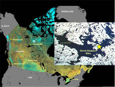 |
|||||
| Site plan showing the location of the four Diavik production kimberlites: |
Page 11 of 21
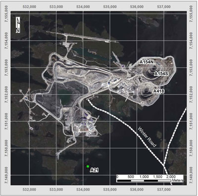 |
|||||
| Cut-away view showing past, existing and planned mine development for the current underground mining: | |||||
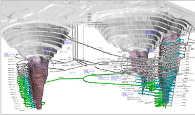 |
|||||
| Illustration of planned dike and open pit design for the fourth kimberlite pipe, A21, currently in development toward production anticipated for late 2018: |
Page 12 of 21
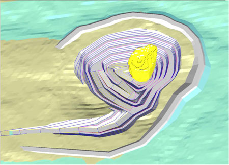 |
|||||
| • | Beyond the current kimberlites in production, none of the new kimberlites discovered to date are currently considered to be significant discoveries. | ||||
| Balanced reporting | • | Estimated sizes of exploration kimberlites are not reported externally. | |||
| Other substantive exploration data | • | Surface geochemical and kimberlitic indicator mineral results, geological mapping and geophysical surveys (gravity, magnetic, frequency and time-domain electromagnetic methods) have been completed and reported to the territorial government as a part of annual work requirements for regulatory purposes and are accessible by the public. No representations to date have been made for investor purposes. | |||
| Further work | • | No further drilling work is planned and exploration has been put on hold for the property. | |||
|
SECTION 3 ESTIMATION AND REPORTING OF MINERAL RESOURCES |
|||||
| Criteria | Commentary | ||||
| Database integrity | • | All data transfer is electronic. All data are validated prior to upload into acQuire databases that are managed and access-controlled by authorised Diavik staff geologists. Core logging data is collected as it is being logged using a laptop with a front end application designed in MS Access. The Access mdb file is formatted to match the acQuire database such that all fields and data types in are identical. When core logging is complete, the new data is added to the database using an import object. This import object contains additional validation and will not import unless the data are formatted correctly. | |||
| • | Diamond stone size analyses are received electronically from an internally affiliated laboratory/processing facility at Thunder Bay, Ontario. Results are reviewed as they are received from the laboratory, whereby each individual sample’s stone size frequency distribution (SFD) is plotted alongside the combined results of the entire drill hole to identify any potential anomalies with processing plant recovery performance, and any discrepancies observed are followed up with a third pick of the concentrate and a review of processing data by the laboratory staff. | ||||
| Site visits | • | The Competent Person (CP) for resource estimation works at site and the CP for ore reserves regularly visits site. | |||
| Geological | • | The grade estimation is unconstrained so internal geology units do not have any effect on the resource. | |||
Page 13 of 21
| interpretation | • | Multiple versions of the model have been run with different assumptions; all have been reconciled with production data to determine the most appropriate method. | |||
| Dimensions | • | The Diavik mineral resource and ore reserve hosts a single mining operation and common facilities, and is comprised of adjacent kimberlite pipes that are considered relatively small by world comparison. Each pipe is carrot-shaped and extends almost to surface with diameters between 100 m to 150 m at the tops and tapering to points at different individual depths currently modelled to between 300 m to more than 500 m below surface. | |||
| • | Production currently comes from three adjacent pipes mined simultaneously by a single crew and feeding a common processing plant, while a fourth pipe is in development for future production to commencing in 2018. | ||||
| • | To maintain accuracy of dimensions, kimberlite/waste contact points are collected both through ongoing drilling and surveying in active mining areas. Volume uncertainty in the proven/probable categories is kept to less than +/-10%. | ||||
| Estimation and modelling techniques |
• | The grade estimation uses unconstrained ordinary kriging (OK) of carats per tonne (cpt or ct/t) in the top portion of the pipes and unconstrained simple kriging (SK) of cpt at lower depths in some of the pipes due to a reduced number of samples. | |||
| • | The estimation uses all samples when estimating blocks within 25 m of a high grade sample but for the estimation of any remaining blocks the grade is decreased. This method better represents the actual variability in grade seen in the mined ore and limits the smearing of high grades into other part of the body. | ||||
| • | Estimate block size is 15 m, just over half the average drill hole spacing and appropriate for the scale of mining being carried out. | ||||
| • | All kimberlite in the reserve is economic and is mined as ore without selectivity and processed as a single blended feed. For model validation, however, production results are reconciled back into separate pipes through back-calculation. | ||||
| • | The validation process includes a visual check of the grade estimation in plan and section views as well as a comparison of average grade /grade distribution between the model and de-clustered sample data. Monthly grade reconciliation is also calculated and reported with periods of anomalous reconciliation for periods of 3 or more months prompting an in-depth investigation. | ||||
| Moisture | • | Core samples are collected at 6 m intervals down hole. A 20 cm piece is wrapped in plastic wrap by the driller’s helper as the core is removed from the core barrel. This piece is retrieved by the logging geologist as part of the logging procedure when the kimberlite is logged. The in-pit samples are collected as the kimberlite is mined. A piece of kimberlite weighing approximately 1 kg is collected at each sample site. Care is taken to choose locations that are as undisturbed as possible so that the geologist is confident that the surveyed coordinates for the sample location reflect true in-situ location. | |||
| • | The procedure for measuring density of the kimberlite is similar for both core and hand samples. The hand sample or core sample is broken into two. One piece is weighed both in air and in water to provide the values necessary to calculate a bulk density. The second piece is weighed in air and then dried in an oven at 110º C for 24 hours. After drying, the sample is weighed in air again which provides the second value needed to calculate a moisture percentage. This moisture percentage is applied to the previously calculated bulk density to provide a dry bulk density which is used for density estimation and reconciliation purposes. | ||||
| Cut-off parameters |
• | Cut-off grade analysis is carried out as part of the reserve/resource definition process for each of the kimberlite pipes that underpin current business plans. Combining modeled grades with modeled cost projections suggests break-even grades for each zone analysed, which modeled grades should exceed in order to be economic. All kimberlite considered for inclusion in mine plans is likely to be economic and, as such, a cut-off grade is not applied. | |||
| Mining factors or assumptions |
• | Since Diavik is a producing mine with an active mining reserve, evaluation of resources outside of reserves is based on assumptions supporting the current mine plan that have been approved and accepted. This is particularly sensible for resources that are extensions of the current mine plan since the likelihood of mining would be under similar conditions. Such assumptions include mining method, mining losses and dilution, plant recovery, prices, and costs (with adjustment for depth/access in relation to current mining). | |||
| • | In the case of resources which would not be mined as straightforward extensions of current mine plans, applicable assumptions supported by studies-in-progress are applied. | ||||
Page 14 of 21
| Metallurgical factors or assumptions |
• | Before running the mineral resource model estimation, metallurgical recoveries are taken into account by adjusting sample grades for production stone size/frequency recovery based on the screen size cut-off in the processing plant. | ||||
| Environmental factors or assumptions |
• | No kimberlite is mined as waste and all is taken to the processing plant. The processing involves gravity, magnetics and x-rays, and no chemical reagents are used whatsoever. The by-product is a non-deleterious processed kimberlite (PK) that is taken to an engineered containment adjacent to the plant. | ||||
| • | Granitic waste rock surrounds the kimberlite pipe. Mining involves the removal of some of this to access the kimberlite. Certain zones of the granitic host rock contain biotite schist which has a sulphur content (low), and so precautions have been taken to segregate and manage this in case there is acid generating potential in the long term. There have been no acid issues to date and the mine closure plan includes permanent safeguards. | |||||
| • | Community leaders, residents and employees are kept updated on environmental impacts and monitoring performance. Community consultation including regular site visits by local elders are part of the evolving mine closure planning efforts, not only for transparency but also to leverage traditional knowledge of the land. | |||||
| Bulk density | • | Kimberlite dry bulk densities are measured from samples taken from the mine and from ongoing delineation programs and a density model is developed using geostatistical methods. | ||||
| Classification | • | Classification is based on: | ||||
| • | appropriate spatial and geological representivity of samples | |||||
| • | sample size effect | |||||
| • | complete size/frequency distribution and therefore accurate mean stone size | |||||
| • | confidence in diamond quality and value | |||||
| • | contact and volume delineation confidence | |||||
| • | sample grade and specific gravity estimation uncertainty | |||||
| • | reconciliation of production data | |||||
| Audits or reviews |
• | An independent Resources and Reserves audit in 2012 identified only minor matters having no material impact on reported figures, and all issues have since been addressed. | ||||
| • | The resources and reserves have been subjected periodically to Rio Tinto and Diavik internal review processes over the years. | |||||
| • | The A21 project underwent an internal Rio Tinto review in 2014. | |||||
| Discussion of relative accuracy/ confidence |
• | Four simulated models are built each year to quantify the uncertainty in value of production and prepare management and sales staff for the variability in production carats that result from using a grade model based on limited numbers of samples. For these models 100 simulations are run, each calculating a single grade variable for each block in the model using ordinary and simple kriging. The kriging parameters used mimic those used in the standard grade estimations at Diavik. The 100 simulated grades are then used to calculate the potential variability in grade which is possible based on the current sample dataset (based on spatial location and variance). | ||||
| • | Grade reconciliation is expected to fall within these calculated uncertainty limits and, if it does not for 3 or more months in a row, an investigation is undertaken. | |||||
| SECTION 4 ESTIMATION AND REPORTING OF ORE RESERVES | ||||||
| Criteria | Commentary | |||||
|
Mineral Resource estimate for conversion to Ore Reserves |
• | Those portions of the mineral resource model that are economically viable after considering the method of mining and associated site-wide operating and capital costs, and after applying reasonable expectations for mining dilution and losses, are converted to Ore Reserves. | ||||
| • | Remaining mineral resources having reasonable likelihood of being mined with economic viability are reported as Mineral Resources in addition to the reported Ore Reserves. | |||||
| Site visits | • | The Competent Person (CP) for resource estimation and the CP for ore reserves are senior professional employees of the mine and undertake site visits as a regular part of their roles. | ||||
| Study status | • | The Ore Reserves underpin a producing mine that has operated continuously and successfully for more than a decade. Initial open pit mine start-up and recent transition to | ||||
Page 15 of 21
| fully underground mining were both supported by bank-approved full/final feasibility studies. An approved full/final feasibility study also supported the addition of the future A21 open pit to the Ore Reserves. | |||||
| Cut-off parameters |
• | Historical and forecasted costs for the operation along with approved price forecasts are used to determine break-even grade. | |||
| • | For the kimberlite pipe deposits in the mine plan, diamond grades throughout the resource/reserve model and forecasted in the mine plans have consistently exceeded the break-even grade by generous margins. As such, selective mining has not been warranted and all kimberlite is sent for processing. | ||||
| Mining factors or assumptions |
• | The selection of underground mining methods has been based on rock strengths and structure, and a requirement for no surface subsidence to maintain the integrity of critical mine site infrastructure. | |||
| • | Mining widths were determined by geo-mechanical analysis during feasibility studies and to date have not been changed materially. | ||||
| • | Access via portals and not by shafts was selected based on the availability of mined-out pits with road/ramp systems in place and a legacy fleet of open pit haulage trucks in good operating order that provide reliable overland ore transport from any of the in-pit portals to the processing plant at an acceptable operating cost and with zero up-front capital cost loading on the UG development funds. | ||||
| • | With no shafts, there is no hoisting option. Given the vertical geometry of the kimberlite pipes being mined, conventional sloped conveyors would provide only limited benefit. Dynamic haulage simulation modeling indicates that the life-of-mine plan can be achieved with manageable UG fleet size and ventilation needs. | ||||
| • | Mining dilution and recovery factors were estimated during the feasibility study based on to-scale stope design drawings, sketches of likely dilution and loss sources, and volume calculations. These have been reviewed and updated on an annual basis as more operating experiences are gained. In general, the feasibility assumptions were conservative as updated factors have generally decreased over time as understanding increases. | ||||
| • | The underground mine is designed to extract the Inferred Resources in each of the three pertinent kimberlite pipes with the expectation that they will be upgraded to Ore Reserves in time. Two versions of a mine plan are produced: a Reserves-only version for reporting purposes and a Reserves-plus-Resources version as an upside and for internal strategic purposes. | ||||
| • | A fourth kimberlite pipe, A21 being reported here for the first time, will bring open pit mining back into the mine plan by the end of 2018. A21 does not extend the mine life but will provide important incremental production alongside ongoing underground output to maintain existing levels of total production over the remaining mine life. | ||||
| • | The A21 open pit has been designed with the same geotechnical and economic rigour used in the mine’s earlier completed open pits. Mining will be carried out using much of the existing equipment from the previous pits and an experienced workforce. Mining dilution and losses are expected to be similar to the outcomes achieved in the earlier pits. | ||||
| Metallurgical factors or assumptions |
• | The ore processing plant was designed by an engineer experienced with diamond kimberlite processing, built by a reputable construction contractor, and began exceeding design capacity and performance expectations early in the mine life. | |||
| • | The plant has been in continuous operation for more than a decade. | ||||
| • | Continuous improvement has been ongoing, resulting in the current plant achieving higher throughput and achieving better diamond recoveries than designed. | ||||
| • | Whilst some plants juggle a trade-off between throughput and recovery, this plant has focused on maximising throughput although the secondary goal of maximising diamond recovery has also been met with notable success. | ||||
| • | Rigorous reconciliation of model to mine to plant is carried out monthly, helping all three areas track performance and calibrate as necessary. | ||||
| • | Ore from all three of the mine’s kimberlite pipes currently in production are processed together, with mine geologist and plant engineer collaborating to optimise the blend from available material on the feed pad for best recovery and throughput. | ||||
| • | Occasionally, mined batches of a particular area or a particular kimberlite type are processed to better understand the performance and/or the product characteristics. | ||||
| • | The stated Ore Reserves take into account the metallurgical recovery. | ||||
Page 16 of 21
| Environmental | • | All necessary permits and licenses have been in place and in good standing since the mine began more than a decade ago. | |||
| • | Ongoing operating activities include regular monitoring of water quality, aquatic effects on fish and roe, air quality and dust loading, wildlife patterns, and land use vis a vis the permit allowances. | ||||
| • | A regulator-approved waste rock management plan is well established. | ||||
| • | Long-term research was initiated early in the mine life in the areas of fish toxicity, effects of ammonia from blasting, effects of chemicals released by mining activity such as phosphates, long-term acid generating potential of waste rock, long-term thermal effects on waste rock dumps and tailings impoundments in the arctic. | ||||
| • | The monitoring and ongoing research has been feeding into the mine closure plan, which is updated approximately every five years. There is regular consultation with local community and aboriginal groups about the mine closure plans, and efforts are made to incorporate Traditional Knowledge to enhance the scientific and social efforts. | ||||
| • | Regulator-approved financial security is in place to cover the current mine closure liability, and the amount of the security is reviewed regularly. | ||||
| Infrastructure | • | The mine site has been fully functional since its start-up more than a decade ago. | |||
| • | The remote site has a federally approved air strip capable of landing 737 jets and C-130 Hercules transports. A modern camp facility provides private rooms and bathrooms to every employee, serves high-quality nutritious meals, has recreation facilities and an adult learning centre offering a range of courses from arts & crafts to university access. The site generates its own electricity from diesel generators and a wind farm. There is bulk fuel storage, wastewater treatment, sewage treatment, waste disposal/incineration, maintenance shops, offices, the ore processing plant, and covered heated pedestrian walkways providing year-round connection to the main facilities protected from the harsh arctic winters. | ||||
| Costs | • | Capital cost assumptions are the prevailing approved capital plan for the mine. | |||
| • | Operating costs are based on area managers’ budget estimates which in many cases are supported by historical costs. Where there is no historical cost, company senior management requires first-principles estimations. | ||||
| • | Approved diamond price assumptions are provided from the product group level, since this is not a listed or a contracted commodity. Diamonds are a pure product; there are no penalties for deleterious co-products. | ||||
| • | Exchange rate forecasts are as prescribed by the corporation. | ||||
| • | Transport charges for rough diamonds are negligible (stones in envelopes carried in a small suitcase), and the security costs are part of operating costs. | ||||
| • | Royalties payable to government as well as private parties are accounted for in the financial modeling. | ||||
| Revenue factors | • | Revenues are based on forecasted carat production after processing and final cleaning, underpinned by mine production forecasts from engineered mine designs and scheduling which in turn are supported by peer- and third-party-reviewed reserve/resource modeling kept up to date with rigorous monthly reconciliation from plant to mine to model. | |||
| • | The calculated estimation uncertainty inherent in the reserve/resource model is carried through the mine plant to the carat production forecast, providing the sales team with expected minimum and upside carat production on either side of a central-case forecast. This helps determine how much product can be locked into sales agreements and what portion should be handled with more flexibility. | ||||
| • | The mine is a joint venture with Rio Tinto holding 60% through a wholly-owned business unit Diavik Diamond Mines (2012) Inc. (“DDMI”). DDMI is the operator and manager of the mine. A 40% share is owned by Dominion Diamond Diavik Limited Partnership, a wholly- owned business unit of Dominion Diamond Corporation headquartered at Yellowknife, Northwest Territories, Canada. | ||||
| • | Rio Tinto’s 60% share of the rough diamonds are sold by DDMI through an agency agreement with the over-arching product group marketing division, and all marketing costs and service fees chargeable to the mine are included as part of DDMI’s operating costs. | ||||
| • | Price assumptions are developed by the marketing division and approved values are passed down to the mine from the product group head. | ||||
Page 17 of 21
| Market assessment |
• | Supply and demand fundamentals for diamonds are favourable and robust for the foreseeable long term. Consumer demand in established markets remains steady but is increasing in emerging countries, notably China and India. Meanwhile, the availability of new discoveries and pace of new mine development lags far behind demand. | |||
| • | Diavik is a part of Rio Tinto Diamonds, a fully integrated global business with 30 years of history in exploration, mining, marketing and sales. RTD has earned a strong position in the industry and is the world’s third-largest supplier of rough diamonds. RTD’s sales and marketing organisation is well-established with a strong and loyal customer base. | ||||
| • | There are no market constraints. Everything produced is sold. | ||||
| Economic | • | All of the foregoing is accounted for in a full-business life-of-mine discounted cash flow model. | |||
| • | For testing proposed new reserves and resources, the output from an updated mineral resource model that has been at least peer-reviewed and sometimes third-party-reviewed is scheduled with applied mining loss/dilution assumed for the selected mining method. Capital costs developed for the scenario(s) and operating costs including mining, processing, site support and corporate overheads are put into the cash flow model. Costs also include marketing, royalties and mine closure. Revenue is calculated using approved price and exchange rate forecasts. A comprehensive taxation model reflecting current Canadian tax laws including the treatment of capital investment and asset depreciation is then applied. | ||||
| • | Viability is indicated by a positive NPV and positive cash flows during production years, except where injections of capital are made to sustain or expand production. In such cases the investment must increase the NPV (i.e. must test for this). The updated Diavik Ore Reserve including A21 is cash accretive under these scenarios. | ||||
| • | Diamond prices are commercially sensitive information and cannot be disclosed either directly or indirectly. | ||||
| Social | • | The company is party to a binding Socio-Economic Monitoring Agreement (SEMA) between government, aboriginal groups/nations, and the company. The SEMA was signed prior to the construction of the mine more than a decade ago and remains in good standing. Commitments have been met or exceeded every single year. | |||
| • | Also before the mine began, the concept of “impact-benefit agreements” was enhanced to ensure full two-way participation and commitment. Participation Agreements were signed and remain in place and in good standing with five aboriginal groups/nations that are impacted by and benefitting from the mine. | ||||
| • | These agreements have formalised mutual commitments in key areas including supply of local labour and services, provision of jobs and training, support by and support to local businesses, community development and scholarships for youth, collaboration on future mine closure plans, sharing of Traditional Knowledge and knowledge gained from environmental monitoring. These commitments remain strong despite democratic changes in community leaders and band chiefs and turnover of company management. | ||||
| Other | • | All of the kimberlite pipes being mined are under a large lake. Past open pit mining and the current open-stoping methods of underground mining are made possible by engineered water-retention dikes that have been built to hold back the lake water until mining is completed and return of the lake water is possible. Developing A21 will require a new dike to be built at that location and construction is presently underway. The structural integrity of these dikes is of critical importance. Full-time monitoring is aided by several different types of instrumentation and automation systems along with daily survey confirmation and visual inspections and reporting. There have been no incidents of concern during the operating life to date. | |||
| • | There have been no charges under any environmental regulation. | ||||
| • | All regulatory permits and licenses have been in good standing every year; those requiring renewal have been so renewed as required. | ||||
| • | There are no political obstacles relating to the export of rough diamonds. | ||||
| • | All mining claims have been secured by conversion to long-term mineral leases. Should the mine life extend beyond the term of the leases, the renewal procedure is an administrative task in which the incumbent lease holder has first rights and merely needs to opt to continue. | ||||
Page 18 of 21
| Classification | • | Since start-up more than a decade ago, past open pit mining was carried out successfully and the current underground mining is proceeding as planned. There have been no reasons to deviate from the following classification criteria for the current Reserve. | ||||
| • | All Measure Resources are considered to be Proved Reserves. | |||||
| • | All Indicated Resources are considered to be Probable Reserves. | |||||
| Audits or | • | The most recent independent third-party audit of reserves and resources took place from April to June 2012. | ||||
| reviews | • | Based on a scale from Weak → Marginal → Satisfactory → Good: | ||||
| Out of 15 audit components, 10 were Good, 4 were Satisfactory, and only 1 was Marginal. | ||||||
| • | There were twenty Findings requiring action, none urgent. All actions are now completed/closed. | |||||
| Discussion of relative accuracy/ confidence |
• | Uncertainty in the Reserve estimated pertains primarily to the accuracy of predictions that are possible from a diamond deposit. There is low uncertainty about conventional mining and processing methods, the operating environment, or saleability of product. | ||||
| • | Diamond deposits are rare and by their nature highly variable. The occurrence of diamonds within a deposit is very low, in the parts-per-million. The variability of grades (carats per tonne) within a diamond deposit can be in the order or 40% or more. The challenge is to model this variability accurately. Despite high variability, it can be modeled accurately with appropriate sampling and estimation techniques. | |||||
| • | The Diavik kimberlites are considered to be well-sampled and well-modeled. | |||||
| • | For Diavik, confidence in the Proved Reserve is approx. +/-15% (this is excellent for any diamond resource model). | |||||
| • | There remain small uncertainties about volume and density at depth, as the drilling and sampling recovery diminishes. | |||||
| • | Diavik’s Probable Reserves occur at depth, and the uncertainty begins to increase as delineation/volume data weakens and combines with grade uncertainty to give a notably higher overall uncertainty. | |||||
| • | This uncertainty means possible upside and not just downside. While this envelope widens with depth, central-case grade estimates remain reasonably consistent throughout. | |||||
| • | These uncertainties (upside as well as downside) are carried through the production forecasting process to provide marketing staff with upside and downside carat production on either side of a central case. This can help shape sales agreements with customers. | |||||
| SECTION 5 ESTIMATION AND REPORTING OF DIAMONDS AND OTHER GEMSTONES | ||||||
| Criteria | Commentary | |||||
| Indicator minerals |
• | Indicator minerals are neither reported nor applicable in mineral resource modeling and reserve reporting for an established producing diamond mine. | ||||
| Source of diamonds |
• | There are four economic kimberlites at Diavik: A154N, A154S, A418 and A21. | ||||
| • | Diamonds sizes and qualities are categorised by production size stones sets of >100,000 carats in the three production pipes. A21 (in development) has been valued using a smaller bulk sample dataset of ~8,000 carats. | |||||
| Sample collection |
• | Core drilling and reverse circulation (RC) drilling from surface and in-pit have been used. Core drilling was used early on the project for delineation and feasibility work while RC drilling has been used subsequently to support development of a production resource model. In-pit level sampling and underground drift sampling has been used in areas where the drilling does not provide adequate coverage. | ||||
| • | A total of 95 drillholes (1,581 samples) have been used for the resource estimate. In pit/underground sampling represents 10 percent of the total samples, core drilling represents 25 percent of the total samples and RC drilling 65 percent. The drill holes are between 15 metres and 532 metres in length and all were drilled vertically. | |||||
| • | Sample programs are designed to be both geologically and spatially representative. | |||||
| Sample | • | All samples were processed by an internally affiliated processing laboratory in Thunder Bay, Ontario. | ||||
| treatment | • | Bottom screen size was 1 mm. Material was sent through a 10 mm rolls crusher, treated by dense media of this material with the float product re-crushed to 6 mm, followed by dense media separation. This material was then put through x-ray machine sorting. The x-ray | ||||
Page 19 of 21
| accepts are hand sorted. The rejects are further crushed to 4 mm, this material and all floats are sent through magnetic separation and caustically fused to reduce manual sorting time. The rejects and floats are then hand sorted. These sample grades are adjusted back to production using reference size frequency distributions. | ||||||||
| • | Microdiamond analysis has not been used for resource modeling. | |||||||
| Carat | • | Industry standard carat weights are used for all reporting. | ||||||
| Sample grade | • | Sample grades are reported in carats per tonne using the bottom screen size cut-off. | ||||||
| • | Stones per tonne values are calculated but not used in the estimation process. | |||||||
| Reporting of Exploration Results |
• | 1 mm has been the lower cut-off size. Recovered stones are sieved three times in square mesh, diamond sieve and grainer series. | ||||||
| • | All processing data is provided in digital format by the Thunder Bay laboratory including sample weights, concentrate weights, and fraction weights. | |||||||
| • | Sample grades are adjusted to production recoveries using reference size frequency distributions. | |||||||
| • | Core samples are collected at 6 m intervals down hole for density measurements. Densities for large diameter reverse circulation (LDRC) samples are taken from the modeled density for the elevation range that the sample was collected from. | |||||||
| Grade | • | A154S | probable – 30 m | proven – 25 m | ||||
| estimation for | • | A418 | probable – 35 m | proven – 28 m | ||||
| reporting | • | A154N | probable – 40 m | proven – 27 m | ||||
| Mineral | • | A21 | probable – 40 m | proven – 28 m | ||||
| Resources and Ore Reserves |
• | Bedding is primarily horizontal so vertical drilling was chosen as the most geologically representative method of sampling. | ||||||
| • | The sample processing flow sheet is designed to mimic production as closely as possible. Sample grades are adjusted at the coarse and fine end of the size frequency distribution to match production recoveries. | |||||||
|
Value estimation |
• | For A154N, ~15,000 carats from an underground bulk sample have been used to calculate carat value. This sample was run through the production plant at the Diavik mine site; consequently, diamond recovery matches typical production. | ||||||
| • | For A154S, carat value is based on six production valuations with a total of 6.7 million carats (~7 months of production). | |||||||
| • | For A418, diamond size distribution is based on 14 weeks of A418-only production (~2.2 million carats) and diamond quality distribution is based on a single production batch of ~186,000 carats. | |||||||
| • | For A21, ~10,000 carats from large diameter core (LDC) and large diameter reverse circulation (LDRC) drilling programs, along with an underground bulk sample, have been used to calculate carat value. | |||||||
| • | Stones are visually inspected for new breakage as they are sieved at the laboratory. Only one of the 15 sampling programs completed has shown signs of significant breakage. | |||||||
|
Security and integrity |
• | Samples are sealed at the drill site and transported from the Diavik mine (at Lac de Gras, Northwest Territories) to the Rio Tinto Exploration laboratory/processing facility (at Thunder Bay, Ontario) via secure trailer from G& G Expediting in the city of Yellowknife. | ||||||
| • | As an assurance testing exercise for the sample processing, a robust sample spiking program was initiated for the A418 and A154N LDRC sample processing program. Samples were either spiked with +1.70mm, +2.36mm, or +3.35mm faceted Argyle diamond spikes or 2 mm or 4 mm density tracers. Spiking locations were varied and included the feed conveyor, the prep screen and the dense media separation (DMS) feed screen. This spiking continues on all samples programs since that time. | |||||||
| • | Core and mini-bulk samples are weighed both at the mine site and at the laboratory. There is no data available for cross-validation of LDRC sample weights as they are calculated from the hole volume and density and the fines have been screened out. Weighed tonnages at the laboratory are compared to caliper tonnages to see if the ratios are reasonable. | |||||||
| Classification | • | Stone frequency values are not reported; grades are measured and reported as carats per tonne. | ||||||
| • | Classification is based on: | |||||||
| • | appropriate spatial and geological representivity of samples | |||||||
| • | sample size effect | |||||||
Page 20 of 21
| • | complete size/frequency distribution and therefore accurate mean stone size | |||||
| • | confidence in diamond quality and value | |||||
| • | contact and volume delineation confidence | |||||
| • | sample grade and specific gravity estimation uncertainty | |||||
| • | reconciliation of production data | |||||
Page 21 of 21
|
Media release |
INCREASE TO HAIL CREEK COAL RESERVES
6 March 2015
To support the annual Mineral Resources and Ore Reserves review process detailed in Rio Tinto’s 2014 Annual report released today, Rio Tinto Coal Australia has declared an increase of its managed coal reserves for its Hail Creek Mine in Queensland, Australia, resulting from the completion of studies and evaluations.
The updated Hail Creek Ore Reserves and Mineral Resources are reported under the Australasian Code for Reporting of Exploration Results, Mineral Resources and Ore Reserves, 2012 (JORC Code) and are set out in the following Tables 1 and 2 and a summary of information, with supporting technical detail in Appendix 1.
Marketable Ore Reserves at Hail Creek have increased by 25 million tonnes (Mt), from 60 Mt to 85 Mt.
| The update is based on a rigorous examination of the mine and operations planning for the Hail Creek project Western Margin including: | |
| • | Reprocessing of a primary coal stream to introduce an additional thermal coal product into the operations and marketing plan. |
| • | Analysing a vast dataset gathered over decades including updates from recent prefeasibility study drilling. |
| • | Transforming the strategic mine planning processes and tools used to estimate Ore Reserves. |
| • | Adopting more efficient Mineral Resource estimation methods. |
The increases to the Hail Creek Ore Reserves have resulted from a broader programme of Orebody Knowledge and Strategic Mine Planning optimisation at Rio Tinto Coal Australia. This process will lead to periodic updates of the Mineral Resources and Ore Reserves for the projects and operations managed by Rio Tinto Coal Australia.
Page 1 of 22
|
Table 1 – Ore Reserves
Ore reserves
| Reserves | Marketable reserves | Marketable reserves | Marketable coal quality |
Average % yield to give marketable reserves |
|||||||||||||||||||||||
| Type of mine (a) |
Coal type (b) | Proved | Probable at end 2014 |
Proved | Probable at end 2014 |
Total 2014 |
Total 2013 |
(c) | (c) | Marketable reserves |
|||||||||||||||||
| COAL (d) | millions of tonnes |
millions of tonnes |
millions of tonnes |
millions of tonnes |
millions of tonnes |
millions of tonnes |
Calorific value MJ/kg |
Sulphur content % |
millions of tonnes |
||||||||||||||||||
| Reserves at operating mines Rio Tinto Coal Australia |
|||||||||||||||||||||||||||
| Hail Creek | O/C | SC + MC | 107 | 20 | 72 | 13 | 85 | 60 | 25.74 | 0.35 | 67 | 82.0 | 70 | ||||||||||||||
Notes
(a) Type of mine: O/P = open pit, O/C = open cut, U/G = underground,
(b) Coal type: SC: steam/thermal coal, MC: metallurgical/coking coal.
(c) Coals have been analysed on an ‘‘air dried’’ moisture basis in accordance with Australian Standards and gross calorific value and sulphur content are reported here on that basis. Marketable Reserves tonnages are reported on a product moisture basis.
(d) For coal, the yield factors shown reflect the impact of further processing, where necessary, to provide marketable coal. Hail Creek Marketable Reserves tonnes increased due to the inclusion of a thermal coal product derived from coarse plant rejects.
Page 2 of 22
Table 2 – Mineral Resources
Mineral resources
| Likely mining method (a) |
Coal type | Coal resources at end 2014 | Total resources 2014 compared with 2013 |
||||||||||||||
| (b) | Measured | Indicated | Inferred | 2014 | 2013 | ||||||||||||
| COAL (c) | millions of tonnes |
millions of tonnes |
millions of tonnes |
millions of tonnes |
millions of tonnes |
||||||||||||
| Rio Tinto Coal Australia | |||||||||||||||||
| Hail Creek | O/C | SC + MC | 60 | 79 | 33 | 172 | 172 | 82.0 | |||||||||
Notes
(a) Likely mining method: O/C = open cut; U/G = underground
(b) Coal type: SC=steam/thermal coal, MC=metallurgical/coking coal.
(c) Rio Tinto reports coal Resources on an in situ moisture basis.
Page 3 of 22
|
Summary of Information to Support Mineral Resource Estimates
Mineral Resource Estimate upgrades for Hail Creek are supported by JORC Table 1 (Section 1 to 3) documents provided in Appendix 1 of this media release and also located at www.riotinto.com/JORC. The following summary of information for Mineral Resource Estimates is provided in accordance with Chapter 5.8 of ASX Listing Rules.
Geology and geological interpretation
Hail Creek is located in the northern part of the Bowen Basin which contains numerous important coal producing intervals in the Permian stratigraphy. The Late Permian Fort Cooper and Rangal Coal Measures host the coal deposits mined at Hail Creek. The main rock types of these measures are sandstone, siltstone and conglomerate, which occur with coal and tuffaceous claystone. Coal quality and geological structure, including coal seam continuity, faulting, and limits of oxidation, sub-crops and igneous intrusions are well defined. Geologic interpretations are supported by surface mapping of outcrops and mining exposures, geophysics (2D/3D seismic, airborne magnetics) and by a comprehensive database containing structural, coal quality and geotechnical data for 6,058 exploration, evaluation and pre-production drill holes.
Drilling techniques
The Hail Creek deposit has been extensively drilled using a combination of open hole and wireline coring techniques. Open holes comprise approximately 83% of all drilling completed with this method primarily employed for the purpose of coal and waste structure definition. Core drilling (predominantly 4C (100mm) but also HQ3 and PQ3 in size) is primarily employed for the purpose of coal quality (CQ), geotechnical and gas sampling. A limited number of 200mm large diameter holes have been drilled to obtain bulk volume samples for coal sizing and handling characterisation studies. This technique comprises just over 1% of total drilled metres.
Geophysical logging was completed for all drill holes employing a comprehensive suite of down hole tools to collect calliper, gamma, density, neutron and sonic measurements. Acoustic scanner measurements were also routinely completed for cored holes to obtain additional data for geotechnical assessments.
Sampling, sub-sampling method and sample analysis method
Total coal core recovery in drill core was above 95% for all holes. Sampling of drill core at Hail Creek was according to a universal standard set of instructions. Samples were bagged at the drill site and then transported to an external accredited laboratory for analysis. All samples were weighed, air-dried and then re-weighed before being crushed to a 19mm top size. A rotary splitter was used to divide the sample into portions available for further analysis.
Coal quality analysis was by a three-stage method comprising raw analysis for all plies followed by washability and product testing on composite samples. All sample treatment and analysis was conducted according to procedures which adhere to Australian or International equivalent standards in National Association of Testing Authorities certified laboratories.
Page 4 of 22
Criteria used for classification
The classification of Mineral Resources into confidence categories was based on a standard process for all RTCA sites. Drill holes were assessed according to the value and reliability of contained data to contribute a point of observation to Mineral Resource classifications. Structure and coal quality confidence limits were plotted on a seam group basis with classification of coal inventory into areas of low, medium or high confidence. These were combined to delineate areas of Measured, Indicated and Inferred coal inventory as a basis for determining Mineral Resource tonnage estimates.
A range of drill hole spacing limits were defined to reflect the inherent variability of the six seam groups modelled within the deposits. Typical distances for structure confidence classification are 125m to 250m for high, 250m to 500m for medium and 1,500m to 3,000m for low. Typical distances for coal quality confidence classification are 250m to 500m for high, 500m to 1,000m for medium and 1,500m to 3,000m for low.
Estimation methodology
Modelling was completed using standard coal resource modelling software. For structural modelling a Finite Element Method (FEM) interpolator was used and for coal quality an inverse distance squared interpolator was used. All surfaces and coal qualities were interpolated into grids with 20 m2 node spacing. Modelling was completed on an iterative basis by checking cross sections and contours of structural and coal quality attributes. Database values were posted on contours to provide a further check. A volume / tonnage check was completed with predecessor models to provide final validation.
Reasonable prospects for eventual economic extraction
A minimum coal thickness of 0.2m and density of 1.8 g/m3 were applied as cut-off parameters for reporting Mineral Resources. Economic resources were defined by a “break even” ($0 margin) Lerchs-Grossman optimised shell for opencast coal – this effectively sets the maximum depth or lowermost seam to be considered.
Summary of Information to Support Ore Reserve Estimates
Ore Reserve Estimate upgrades for Hail Creek are supported by JORC Table 1 (Section 4) documents provided in Appendix 1 of this media release and located at www.riotinto.com/JORC. The following summary of information for Ore Reserve Estimates is provided in accordance with Chapter 5.9 of ASX Listing Rules.
Economic assumptions
Rio Tinto applies a common process to the generation of commodity prices across the group. This involves generation of long-term price curves based on current sales contracts, industry capacity analysis, global commodity consumption and economic growth trends. In this process, a price curve rather than a single price point is used to develop estimates of mine returns over the life of the project. The detail of this process and of the price point curves is commercially sensitive and is not disclosed.
Page 5 of 22
Criteria used for classification
The stated Proved and Probable Ore Reserves directly coincide with the Measured and Indicated Mineral Resources, respectively. There are no Inferred or Unclassified resources included in the stated reserve numbers.
Mining and recovery factors
Mine design strips and blocks were applied to the in-situ coal resource model to generate the raw Reserves used to create a separate mine schedule database. The mine schedule database also reflects working sections or seam aggregations, mining methods and associated loss and dilution impacts. The mine schedule database was used as the basis for Ore Reserves reporting.
The Hail Creek mine utilises dragline, truck and shovel for waste movement, while coal is loaded using a combination of loaders and excavators with haulage to the Run Of Mine (ROM) hopper undertaken using rear dump trucks. The operations are supported by additional equipment including dozers, graders and water carts.
All pit end-walls have benched and battered designs based on typical Rio Tinto Coal Australia practice with allowances made for increasing depth of mining. The design provides for mining roadways and catch benches.
Cut-off grades
Working section or seam aggregation logic pre-determines what is defined as mineable coal by applying working section tests based on minimum coal thickness of 30cms.
Coal loss and dilution factors are also applied and vary by the equipment type uncovering the various coal seams (i.e. excavator/truck versus dragline). Typical roof and floor coal loss thickness ranges from 2cm–59cm. Typical roof and floor waste dilution thickness ranges from 4cm–16cm.
Processing
The processes used across the operating mines and projects are standard for the coal industry and so are well tested technologies. All samples were wash/cut-point tested and so the representativeness of test work undertaken is implicit in the Resource classification status.
In-seam dilution was included in sample testing.
Ore Reserve estimation was based on existing product specifications.
A secondary thermal product is a new feature of the reserves and is produced from the rejects streams of the primary products. The reserve is based on a 25% ash thermal that has been tested with the market throughout 2014.
Modifying factors
Rio Tinto Coal Australia has an extensive environmental and heritage approval and compliance process. No issues are expected that would impact on the Mineral Reserve estimate. Mining operations, management of waste, and storage/discharge of any solids,
Page 6 of 22
liquids or gases, meet current environmental requirements. All necessary Government approvals are expected to be received within the timeframes anticipated in the life of mine (LOM) plan.
Hail Creek is an operating site with existing infrastructure in place to support the operation. The current LOM requires sustaining capital only to maintain the existing infrastructure.
Page 7 of 22
Competent Persons Statement
The information in this report that relates to Mineral Resources is based on information compiled by Dr Richard Ruddock, a Competent Person who is a Member of The Australasian Institute of Mining and Metallurgy. Dr Ruddock is a full-time employee of the company.
The information in this report that relates to Ore Reserves is based on information compiled by Mr Matthew Hillard, a Competent Person who is a Member of The Australasian Institute of Mining and Metallurgy. Mr Hillard is a full-time employee of the company.
Dr Ruddock and Mr Hillard have sufficient experience that is relevant to the style of mineralisation and type of deposit under consideration and to the activity being undertaken to qualify as Competent Persons as defined in the 2012 Edition of the ‘Australasian Code for Reporting of Exploration Results, Mineral Resources and Ore Reserves’. Dr Ruddock and Mr Hillard consent to the inclusion in the report of the matters based on the information in the form and context in which it appears.
Page 8 of 22
Contacts
www.riotinto.com
Follow @RioTinto on Twitter
| Media Relations, EMEA/Americas | Media Relations, Australia/Asia | |
| Illtud Harri | Ben Mitchell | |
| T +44 20 7781 1152 | T +61 3 9283 3620 | |
| M +44 7920 503 600 | M +61 419 850 212 | |
| David Outhwaite | Bruce Tobin | |
| T +44 20 7781 1623 | T +61 3 9283 3612 | |
| M +44 7787 597 493 | M +61 419 103 454 | |
| David Luff | Matthew Klar | |
| T + 44 20 7781 7781 | T +61 7 3625 4244 | |
| M +44 7780 226 422 | M +61 457 525 578 | |
| Investor Relations, EMEA/Americas | Investor Relations, Australia/Asia | |
| John Smelt | Rachel Storrs | |
| T +44 20 7781 1654 | T +61 3 9283 3628 | |
| M +44 7879 642 675 | M +61 417 401 018 | |
| David Ovington | Galina Rogova | |
| T +44 20 7781 2051 | T +852 2839 9208 | |
| M +44 7920 010 978 | M +852 6978 3011 | |
| Grant Donald | ||
| T +44 20 7781 1262 | ||
| M +44 7920 587 805 | ||
| Rio Tinto plc | Rio Tinto Limited | |
| 2 Eastbourne Terrace | 120 Collins Street | |
| London W2 6LG | Melbourne 3000 | |
| United Kingdom | Australia | |
| T +44 20 7781 2000 | T +61 3 9283 3333 | |
| Registered in England | Registered in Australia | |
| No. 719885 | ABN 96 004 458 404 |
Page 9 of 22
Appendix 1 Hail CreekJORC Table 1
The following table provides a summary of important assessment and reporting criteria used at Hail Creek Mine for the reporting of exploration results and coal Resources in accordance with the Table 1 checklist in The Australasian Code for the Reporting of Exploration Results, Mineral Resources and Ore Reserves (The JORC Code, 2012 Edition). Criteria in each section apply to all preceding and succeeding sections.
| SECTION 1 SAMPLING TECHNIQUES AND DATA | ||||
| Criteria | Commentary | |||
| Sampling techniques |
• | A combination of open hole (predominantly for structural definition) and cored (for coal quality (CQ), geotechnical and gas sampling) have been used. | ||
| Drilling techniques | • | 6,058 drill holes (578,879m) support the Resource estimate. Cored drilling represents 17% of the total metres, and open hole drilling 83%. The drill holes are up to 518m deep and average 84m. The drill holes were all nominally recorded as vertical with a redrill required if the hole exceeds specified deviation. | ||
| • |
Coring has predominantly been done using a 4C-sized bit (576 holes at 100mm) and open hole drilling to an equivalent hole diameter size. In addition a number of HQ-3, PQ-3 and large diameter (LD) holes have been drilled: 93 holes HQ-3 (63mm), 52 holes PQ-3 (83mm), and 78 holes LD (200mm) diameter sizes.
| |||
| Drill sample | • | Standardised Rio Tinto Coal Australia logging systems are utilised for all drilling logging and sampling. | ||
| recovery | ||||
| • | Core recovery is recorded by the geologist while logging the drill hole. If core recovery for a coal ply is less than 95%, then that section of the hole is redrilled to ensure a representative sample is taken. | |||
| • | Ply samples are checked for representativeness using a theoretical mass that is determined using analysed relative density, sample thickness and core diameter prior to composite definition. | |||
| • |
Open hole chip recovery is assessed qualitatively by the rig geologist.
| |||
| Logging | • | Core is geologically and geotechnically logged and open hole chip samples are taken every 1m and logged for lithology changes. Logging for lithology, grainsize, weathering and hardness is conducted using standard dictionary definitions. Colour and any additional qualitative comments are also recorded. All core is photographed on both a core table (0.5m increment) and a single 2.8m core tray basis for 4-C and PQ-3 and single 4.5m core tray basis for HQ-3. Chips are photographed in 20m × 1m intervals. | ||
| • |
All holes are logged using a comprehensive suite of downhole geophysics tools (calliper, gamma, density, neutron, sonic, verticality, temperature) with acoustic scanner (for geotechnical assessment) also run on cored holes.
| |||
| Sub-sampling techniques and sample preparation | • | Core sampling is completed at the drill site and based on set of standard criteria (determined by lithology and structure). Samples are bagged at the drill site and then transported to an external accredited laboratory for analysis as a complete hole batch. | ||
| • | All samples are weighed, air-dried and then re-weighed before being crushed to a 19mm top size. A rotary splitter is used to divide the sample into portions available for further CQ analysis. | |||
| • | CQ analysis is by a three stage method involving raw analysis on all plies followed by washability and product testing on composite samples as defined by the project geologist. | |||
| • |
All sample treatment and analysis is conducted according to procedures which adhere to Australian (or International equivalent) standards in a National Association of Testing Authorities certified laboratory.
| |||
Page 10 of 22
| Quality of assay data and laboratory tests |
• |
Non-formalised quality assurance/quality control (QAQC) involving duplicate samples is completed and, in addition, Rio Tinto Coal Australia checks laboratory round robin and basic reproducibility tests provided by the primary laboratory. All results are assessed via cross-plots and statistics for precision and accuracy.
| |||
| Verification of sampling and | • | All CQ sampling and analysis is overseen and checked by other Rio Tinto personnel. | |||
| assaying | |||||
| • |
Data transfer from site is covered by an agreed protocol. This system documents primary data, data entry procedures, data verification, and data storage (physical and electronic) into a geological database.
| ||||
| Location of data points | • | The topographic grid has been constructed from an orthophoto DTM obtained from AAM Hatch on 18 June 2002. The grid has a 20m cell size and covers the entire Hail Creek Syncline as shown in Figure 2 below. | |||
| • | All surveyed co-ordinates are within Australian Geodetic Datum 1984 (MGD84) MGA Zone 55. | ||||
| • | Drill hole collars were surveyed post drilling by licensed surveyors (Hail Creek Mine employees) using differential GPS with an accuracy of ±10mm. | ||||
| • |
Downhole surveying has been undertaken using downhole verticality and calliper tools for all holes 2005 onwards. From all holes drilled and modelled at Hail Creek, 49% of cored holes have verticality data and 44% of open holes have verticality data recorded.
| ||||
| Data spacing and distribution | • | Drill hole spacing for core holes is on an equilateral triangle grid of 500m or less. For open holes, spacing is on a 250m or less equilateral triangle grid. Holes for sub-crop delineation were drilled on a distance as required (observed <100m). | |||
| • | Due to the maturity of the exploration, the majority of the recently drilled holes (2012 to 2014) were not set on a grid basis but rather governed by required data. | ||||
| • | Pre-production holes are based on sub-100m grid spacing (between 75m- 86m). | ||||
| • |
All core samples are composited within defined seam boundaries.
| ||||
|
Orientation of data
|
• | The Coal Measures show relatively consistent layering and are not subject to steep dips – the orientation of drilling is therefore suitable for flat lying stratified deposits. | |||
| Sample security | • |
Core/chip samples are taken at the drill site and then transported daily to the exploration office for storage under refrigeration. Once the hole has been completed the samples are transported to the laboratory via a dedicated courier service again under refrigeration.
| |||
| Audits or reviews | • | Hail Creek has had three audits completed in the past six years, they include: | |||
| ○ | An audit in September 2014 conducted by the Xstract Group (report: Rio Tinto Group Audit and Assurance Resources Internal Audit: Hail Creek Mine) | ||||
| ○ | An audit in October 2010 conducted by the Xstract Group (report: Resources and Reserves Internal Audit – Hail Creek Mine. Project No. P1361) | ||||
| ○ | An audit in November 2009 conducted by Snowden (report: Rio Tinto Corporate Assurance: Resources and Reserves Internal Audit – Hail Creek Mine. Project No. 00509). | ||||
| • |
These reviews concluded that the fundamental data collection techniques are appropriate.
| ||||
Page 11 of 22
| SECTION 2 REPORTING OF EXPLORATION RESULTS | |||||||
| Criteria | Commentary | ||||||
| Mineral tenement and land tenure status | • | Hail Creek Mine is operated under a joint venture agreement. The joint venture partners are listed below: | |||||
| ○ | Queensland Coal Pty Limited* | (82% share) | |||||
| ○ | Marubeni | (6.6667% share) | |||||
| ○ | Sumisho | (3.3333% share) | |||||
| ○ | Nippon Steel Australia | (8% share). | |||||
| * A 100% owned subsidiary of Rio Tinto Ltd. | |||||||
| • | The area making up the Hail Creek Resource model makes up the eastern portion of ML 4738. | ||||||
| • | Other licences and permits includes: | ||||||
| ○ | two exploration permits | ||||||
| ○ | two mining development licences. | ||||||
 | |||||||
|
Figure 1 HCM mining and tenements map
| |||||||
| Exploration done by other parties | • | Small government and private coal exploration was undertaken between 1887 and 1969, but only small Reserves were reported for the Elphinstone and Kemmis Creek coalfields. The realisation of the Hail Creek syncline for coking coal was not until 1969. Mine administration undertook extensive exploration during the 1970s. The project partners took some poor options in testing the coal. Frequent changes of project ownership and personnel hampered the interpretation and documentation of this early work. | |||||
| • |
All exploration of the Hail Creek Syncline after the major partnering of Rio Tinto in the early 1990s was conducted by Pacific Coal Pty Ltd followed by the current custodian, Rio Tinto Coal Australia Pty Ltd.
| ||||||
| Geology | • |
Hail Creek is located in the northern part of the Bowen Basin which contains numerous important coal producing intervals in the Permian stratigraphy. The Late Permian Fort Cooper and Rangal Coal Measures host the coal deposits mined at Hail Creek. The main rock types of these measures are sandstone, siltstone and conglomerate, which occur with coal and tuffaceous claystone.
| |||||
|
Drill hole |
• |
Drilling data summary of Hail Creek for periods 1993-2001 and 2003-2014:
| |||||
| Table 1: Drilling activities for period 1993-2001 | ||||||||||||||||||
| Year | Open Holes |
HQ3 Core |
100mm Core |
Large Core |
Totals | |||||||||||||
| 1993 | No. of holes | 7 | 2 | - | 8 | 17 | ||||||||||||
Page 12 of 22
| Metres drilled | 612 | 88 | - | 369 | 1,069 | |||||||||||||
| 1994 | No. of holes | 46 | - | - | - | 46 | ||||||||||||
| Metres drilled | 4,220 | - | - | - | 4,220 | |||||||||||||
| 1995-96 | No. of holes | 392 | 19 | 53 | 11 | 475 | ||||||||||||
| Metres drilled | 26,903 | 718 | 4,712 | 705 | 33,038 | |||||||||||||
| 1997 | No. of holes | 65 | - | 13 | 34 | 112 | ||||||||||||
| Metres drilled | 7,566 | - | 844 | 2,008 | 10,417 | |||||||||||||
| 1998 | No. of holes | 602 | 1 | 50 | - | 653 | ||||||||||||
| Metres drilled | 29,263 | 37 | 2,698 | - | 31,998 | |||||||||||||
| 2001 | No. of holes | - | - | - | 6 | 6 | ||||||||||||
| Metres drilled | - | - | - | 292 | 292 |
Table 2: Drilling activities for period 2003-2014 |
|||||||||||||||||
| Year | Drilling
Detail |
Open Holes |
HQ3 Core | PQ3 Core | 100mm
Core |
Large
Core |
Totals | ||||||||||
| 2003 | No. of holes | 508 | 9 | - | 173 | 3 | 693 | ||||||||||
| Metres drilled | 22,418 | 559 | - | 7,323 | 149 | 30,449 | |||||||||||
| 2004 | No. of holes | 781 | 10 | - | 82 | 11 | 884 | ||||||||||
| Metres drilled | 46,043 | 326 | - | 7,680 | 965 | 55,014 | |||||||||||
| 2005 | No. of holes | 1,033 | 38 | - | 83 | 7 | 1,161 | ||||||||||
| Metres drilled | 99,420 | 8,832 | - | 8,527 | 829 | 117,608 | |||||||||||
| 2006 | No. of holes | 248 | - | - | 32 | - | 280 | ||||||||||
| Metres drilled | 15,927 | - | - | 2,184 | - | 18,111 | |||||||||||
| 2007 | No. of holes | 511 | - | - | 53 | - | 564 | ||||||||||
| Metres drilled | 39,757 | - | - | 4,741 | - | 44,498 | |||||||||||
| 2008 | No. of holes | 51 | 0 | 0 | 30 | 16 | 97 | ||||||||||
| Metres drilled | 6,289 | 0 | 0 | 4,909 | 1,777 | 12,975 | |||||||||||
| 2009 | No. of holes | 126 | 4 | 0 | 84 | 7 | 221 | ||||||||||
| Metres drilled | 22,525 | 721 | 0 | 13,866 | 662 | 40,832 | |||||||||||
| 2010 | No. of holes | 242 | - | - | 45 | 5 | 292 | ||||||||||
| Metres drilled | 39,753 | - | - | 7,047 | 704 | 47,504 | |||||||||||
| 2011 | No. of holes | 118 | 6 | 26 | 29 | 0 | 179 | ||||||||||
| Metres drilled | 23,992 | 1,618 | 8,592 | 5,297 | 0 | 39,499 | |||||||||||
Page 13 of 22
| 2012 | No. of holes | 134 | 5 | 12 | 12 | 0 | 162 | ||||||||||||
| Metres drilled | 30,122 | 1,429 | 2,592 | 2,734 | 0 | 36,108 | |||||||||||||
| 2013 | No. of holes | 157 | 27 | 24 | 0 | 0 | 208 | ||||||||||||
| Metres drilled | 45,429 | 7,298 | 4,654 | 0 | 0 | 57,381 | |||||||||||||
| 2014 | No. of holes | 41 | 2 | 23 | 66 | ||||||||||||||
| Metres drilled | 19,025 | 764 | 3,478 | 23,267 | |||||||||||||||
|
Data aggregation methods
|
• |
Ply samples are combined to create composites (for washability and product coal analyses) representing mineable seam working sections.
|
|||||||||||||||||
|
Relationship between mineralisation
|
• | Based on drilling techniques and stratigraphy, the coal seam intercepts approximate true coal thickness. | |||||||||||||||||
Page 14 of 22
| Diagrams |
Figure 2: Hail Creek location | |||
|
Open holes (blue); cored holes (red) | ||||
| Figure 3 Drill collar locations | ||||
| Page 15 of 22 |
|
Active pit (white), underground (orange), and eastern margin (blue) exploration targets
Figure 4 Current Hail Creek activities | |||
 | |||
|
Cross-section A is north to south / cross-section B is west to east | |||
| Figure 5 Hail Creek cross-sections | |||

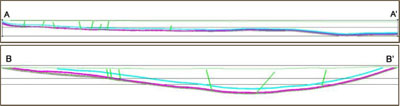
| Page 16 of 22 |
| Balanced reporting | • | Not applicable. Rio Tinto Coal Australia has not specifically released exploration results for these deposits. | ||
| Other substantive exploration data | • | In addition to drilling, a 3D seismic survey (underground exploration target) and airborne magnetic surveys have been completed to delineate structure, faults, dykes, and alluvial limits. | ||
| Further work | • | Drilling for both pre-production and strategic brownfields, and analytical (CQ, geotechnical, gas) results will be ongoing. | ||
| • |
Brownfields exploration includes a potential eastern margin, an underground Resource, and potential coal Resources in the south of the syncline.
|
| SECTION 3 - ESTIMATION AND REPORTING OF MINERAL RESOURCES | ||||
| Criteria | Commentary | |||
| Database integrity | • | All drill hole data are securely stored in a database which is stored on the Brisbane server and is backed up daily. | ||
| • | Data are validated at the drill site and also prior to loading into the database by the responsible geologist. | |||
| • | The database contains automated validation processes, during data loading to prevent un-validated data being loaded. | |||
| Site visits | • | The Resources Competent Person visited Hail Creek in 2014. | ||
| Geological interpretation | • | The deposit is a south-southeast plunging, asymmetrical syncline with all major structures defined. The deposit is part of a series of anticlines and synclines known as the Nebo Synclinorium. Infill drilling, 3D seismic, mining exposure and mapping has supported and refined the model. The current interpretation is thus considered to be robust. | ||
| Dimensions | • | The deposit trends 14km north-northwest to south-southeast and is 6km in width. The deposit extends to a depth of 530m below the topographic surface in the south. | ||
| Estimation and modelling techniques | • | Modelling was undertaken using resource modelling software. For structural modelling the Fine Element Method (FEM) interpolator is used and for CQ an inverse distance squared interpolator is used. All surfaces and coal qualities are interpolated into grids with 20m × 20m node spacing. | ||
| • | The model is of the coal seams only and waste modelled by default and not assigned any grade. Resource estimates are therefore of the coal seams only and restricted on a whole seam group basis only. | |||
| • | Modelling is completed on an iterative basis with checking of cross-sections and contours of structural and CQ attributes. Database values are posted on contours as a further check. A volume/tonnage check between the model and its predecessor are completed as a final validation. | |||
| Moisture | • |
All tonnages are estimated on an in situ moisture basis, which is determined to be air-dried moisture content plus 5%.
| ||
| Page 17 of 22 |
| Cut-off parameters | • | Nominally coal is washed to produce two primary coking products: | ||||
| ○ | a premium low-ash (8.5 per cent) prime hard coking product | |||||
| ○ | a higher ash (10 per cent) hard coking product. | |||||
| • | Blending of coal from the two seams (Elphinstone and Hynds) is common. | |||||
| • | A secondary thermal product has recently been introduced from the rejects streams of the above products and is a 25% ash product. | |||||
| • | The site also produces smaller amounts of bypass thermal rejects. | |||||
| • | For all products, product moisture is 10%. Air-dried moisture is quoted at a 1.5% moisture basis. | |||||
| Mining factors or assumptions | • | Development of this Mineral Resource estimate assumes mining using standard Rio Tinto Coal Australia equipment. | ||||
| • | The assumed open-cut mining method is overburden removal via draglines, and conventional truck and shovel open pit coal mining. | |||||
| • | Mining practices utilise detailed extraction plans to effectively manage grade control. These extraction plans are generated from short term geological models, in pit visual inspections and survey monitoring and control. | |||||
| • | Conceptual underground mining will be by longwall methods. | |||||
| • | Expected mining by seam and product is illustrated in the figure below: | |||||
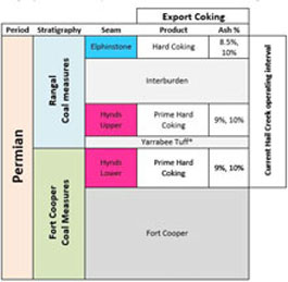 | ||||||
| *The non- coal Yarrabee Tuff is included in Hynds coal extraction | ||||||
| Figure 6 Hail Creek operations and products by seam | ||||||
| Metallurgical factors or assumptions | • | It is assumed that a combination of density separation (magnetite/water) and fines flocculation processes used by Rio Tinto Coal Australia will be applicable for the processing of Hail Creek coal. | ||||
| Environmental factors or assumptions | • | Rio Tinto Coal Australia has an extensive environmental and heritage approval and compliance process. No issues are expected that would impact on the Mineral Resource estimate. | ||||
| Bulk density | • | All boreholes are reported on relative density (RD). | ||||
| • | The in situ relative density; i.e. the density of materials at an in situ moisture basis, was calculated using the Preston and Sanders equation: | |||||
| RD2=[RD1*(100-M1)]/[100+RD1*(M2-M1)-M2] | ||||||
| Where RD1 is true RD (ad), M1 is moisture (ad) and M2 is the in situ moisture. | ||||||
| Page 18 of 22 |
| Classification | • | The classification of the Mineral Resources into varying confidence categories is based on a standardised process of utilising points of observation (PoO) (ie drill holes) according to their reliability and value in estimation. The points of observation are used to categorise structure and quality continuity (or both) or support continuity. | ||||
| • | Radii of influence are then plotted around PoO maps for structure and quality. The radii of influence were determined by consideration of the perceived and observed variability in structure and CQ for seams, and using small radii than that recommended in a geostatistical review previously undertaken. | |||||
| • | Areas of confidence (low, medium, high) are produced from these plots (structure, CQ for each seam) and these are finally combined to produce areas of Measured, Indicated and Inferred which are used to subdivide the resource tonnage estimates. | |||||
| • | In summary structural radii range 125-250m for high confidence, 250-500m for medium and 750-1,500m for low; and, for CQ 250-500m radii for high, 500-1,000m for medium and 1,500-3,000m for low confidence respectively. | |||||
| • | The Competent Person is satisfied that the stated Mineral Resource classification reflects the geological controls interpreted and the estimation constraints of the deposits. | |||||
| Audits or reviews | • | Hail Creek has had three audits completed in the past six years, they include: | ||||
| ○ | An audit in September 2014 conducted by the Xstract Group (report: Rio Tinto Group Audit and Assurance Resources Internal Audit: Hail Creek Mine) | |||||
| ○ | An audit in October 2010 conducted by the Xstract Group (report: Resources and Reserves Internal Audit – Hail Creek Mine. Project No. P1361) | |||||
| ○ | An audit in November 2009 conducted by Snowden (report: Rio Tinto Corporate Assurance: Resources and Reserves Internal Audit – Hail Creek Mine. Project No. 00509). | |||||
| • | These reviews concluded that the modelling and estimation techniques are appropriate | |||||
| Discussion of relative accuracy/ confidence | • | Rio Tinto Coal Australia operates multiple mines in New South Wales (NSW) and Queensland. The Mineral Resource data collection and estimation techniques used for the Hail Creek deposit are consistent with those applied at other deposits which are being mined. Reconciliation of actual production with the Mineral Resource estimates for the existing operational deposits are generally within three percent for tonnes. This result is indicative of a robust process. | ||||
| • | Accuracy and confidence of Mineral Resource estimation estimate has been accepted by the Competent Person. | |||||
| SECTION 4 ESTIMATION AND REPORTING OF ORE RESERVES | ||||||
| Criteria | Commentary | |||||
| Mineral Resource estimate for conversion to Ore Reserves | • | A 3D gridded resource model of topography, structure and quality are used for in situ resource definition. | ||||
| • | Mine design strips and blocks are applied to the in situ resource model to generate the raw Reserves used to create a separate mine schedule database. The mine schedule database also reflects working sections or seam aggregations, mining methods and associated loss and dilution impacts. The mine schedule database is used as the basis for Coal Reserves reporting. | |||||
| • | Coal Resources are in addition to Coal Reserves. | |||||
| Page 19 of 22 |
| Site visits | • | The Reserves Competent Person has visited Hail Creek Operations numerous times over 5 years of involvement. | ||
| Study status | • | Hail Creek is an operating mine project. The reportable Ore Reserve is based on the Life of Mine (LOM) plan assumptions and has determined a mine plan that is technically achievable and economically viable, and that material modifying factors have been considered. | ||
| Cut-off parameters | • | Periodic (<3yrs) pit optimisation work used to define pit shells is conducted using Rio Tinto economics prices and an estimate of unit operating costs including a $/ROMt allowance for sustaining capex. | ||
| • | For annual JORC Reserves reporting purposes, detailed mine design and schedules are constructed to generate detailed cash flow schedules. This work includes identifying the mining sequence, equipment requirements, incremental and sustaining capital. | |||
| • | A discounted cashflow analysis is conducted to re-assess under the latest economic assumptions the potential Reserves that remain net cashflow positive. | |||
| Mining factors or assumptions | • | The Hail Creek mine utilises dragline, truck and shovel for waste movement, while coal is loaded using a combination of loaders and excavators with haulage to the Run Of Mine (ROM) hopper undertaken using rear dump trucks. The operations are supported by additional equipment including dozers, graders and water carts. | ||
| • | All pit end-walls have benched and battered designs based on the existing operation with allowances made for increasing depth of mining. The design provides for mining roadways and catch benches. | |||
| • | Working section or seam aggregation logic pre-determines what is defined as mineable coal by applying working section tests based on minimum coal thickness of 30cms. | |||
| • | Coal loss and dilution factors are also applied and vary by the equipment type uncovering the various coal seams (i.e. excavator/truck versus dragline). Typical roof and floor coal loss thickness ranges from 2cm–59cm. Typical roof and floor waste dilution thickness ranges from 4cm–16cm. | |||
| • | Life of Mine Plans for strategic planning purposes may contain Inferred Resources, provided that the LOM plan would not be compromised by non-inclusion of this coal. Inferred Resources included in LOM plans retain this designation and are not to be referred to as Reserves. Neither are they to be reported in JORC or Securities and Exchange Commission compliant reserve statements. | |||
| • | Hail Creek mine has only limited (<14%) inferred coal within the existing LOM plan. | |||
| Metallurgical factors or assumptions | • | Hail Creek has a coal handling and preparation plant (CHPP) that is operational, which is used as a coal handling plant and is also used to wash all coal. | ||
| • | The processes used are standard for the coal industry and so are well tested technologies. | |||
| • | All samples are wash/cut-point tested and so the representativeness of test work undertaken is implicit in the resource classification status. | |||
| • | In-seam dilution is included in sample testing. | |||
| • | Coal Reserve estimation is based on existing product specifications. | |||
| • | A secondary thermal product is a new feature of the reserves and is produced from the rejects streams of the primary products. | |||
| • | The additional reserve is based on a 25% ash thermal that has been tested with the market throughout 2014. | |||
| Environmental | • | Coarse rejects are combined with fine tailings to form a co-disposal slurry that is | ||
| Page 20 of 22 |
| pumped to an emplacement area. Rejects material must be covered by inert waste rock material. | ||||
| • | Ex-pit dumps are offset from any creeks to prevent any constriction of creek flows. | |||
| • | Overburden waste rock has low acid forming potential. | |||
| Infrastructure | • | Hail Creek is an operating site with existing infrastructure in place to support the operation. The current LOM requires sustaining capital only to maintain the existing infrastructure. | ||
| Costs | • | Based on detailed Annual Operating Plan (AOP) process. Beyond AOP, sustaining capex based on $/ROMt plus equipment replacements and additions required to deliver the mine plan. | ||
| • | First principles estimating and aligned with AOP. Budget prices for major consumables and labour. | |||
| • | Adjustments are made for ash. | |||
| • | Commodity prices supplied by the economics and markets team, based on expected demand, and current supply, known expansions and expected incentivised supply. | |||
| • | Exchange rates supplied by the economics and markets team. | |||
| • | Transport charges obtained from coal chain team based on existing contracts and expected tonnages. | |||
| • | State Government royalties are based on current Queensland (QLD) royalty rates. | |||
| Revenue factors | • | Rio Tinto applies a common process to the generation of commodity prices across the group. This involves generation of long-term price curves based on current sales contracts, industry capacity analysis, global commodity consumption and economic growth trends. In this process, a price curve rather than a single price point is used to develop estimates of mine returns over the life of the project. The detail of this process and of the price point curves is commercially sensitive and is not disclosed. | ||
| Market assessment | • | The supply and demand situation for coal is affected by a wide range of factors, and coal consumption changes with economic development and circumstances. Rio Tinto Coal Australia delivers products aligned with its Mineral Resources and Ore Reserves, these products have changed over time and successfully competed with coal products supplied by other companies. | ||
| Economic | • | Economic inputs such as foreign exchange rates, carbon pricing, and inflation rates are also generated internally at Rio Tinto. The detail of this process is commercially sensitive and is not disclosed. | ||
| Social | • | There are no Native Title Claims over Hail Creek that would impact on Reserves. No Reserves have been omitted on this basis. | ||
| • | A process is embedded in the normal operating regime at Hail Creek to provide cultural heritage clearance such that no effects are expected to restrict the Hail Creek Reserves. As part of releasing a ground disturbance permit on site, authority must be gained to destroy/remove sites of cultural interest. This involves archaeological mapping and removal of artefacts prior to ground disturbance. | |||
| • | There are no sites of European Cultural Heritage at Hail Creek. | |||
| Other | • | Semi-quantitative risk assessments have been undertaken throughout the LOM and Reserve phases. No material naturally occurring risks have been identified through the above mentioned risk management processes. | ||
| Classification | • | The Ore Reserves consist of 84% Proved Reserves and 16% Probable | ||
| Page 21 of 22 |
| Reserves. | ||||||
| • | The Competent Person is satisfied that the stated Ore Reserve classification reflects the outcome of technical and economic studies. | |||||
| Audits or reviews | • | Hail Creek has had three audits completed in the past six years, they include: | ||||
| ○ | An audit in 2014 conducted by the Encompass mining group (reports: External review of the HCX PFS mine Planning Data and modelling – April 2014; External review of the HCX Step 2 PFSA Mine Planning Data and modelling – December 2014.) | |||||
| ○ | An audit in October 2010 conducted by the Xstract Group (report: Resources and Reserves Internal Audit – Hail Creek Mine. Project No. P1361) | |||||
| ○ | An audit in November 2009 conducted by Snowden (report: Rio Tinto Corporate Assurance: Resources and Reserves Internal Audit – Hail Creek Mine. Project No. 00509). | |||||
| • | These reviews concluded that the fundamental data collection and modelling techniques are appropriate and consistent with previously audited Hail Creek models. | |||||
| Discussion of relative accuracy/confidence | • | Rio Tinto Coal Australia operates multiple mines in Queensland and NSW. The Ore Reserve estimation techniques utilised for the Hail Creek Operation are consistent with those applied across the other operations. Reconciliation of actual production with the Ore Reserve estimate for the existing operations is generally within 5% for tonnage and grade. This result is indicative of a robust Ore Reserve estimation process. | ||||
| • | Accuracy and confidence of modifying factors are generally consistent with the current operation. | |||||
| Page 22 of 22 |
| |
Media release |
INCREASE TO PILBARA ORE RESERVES AND MINERAL RESOURCES
6 March 2015
To support the annual Mineral Resources and Ore Reserves review process detailed in Rio Tinto’s 2014 Annual report released today, Rio Tinto Iron Ore has declared an increase of its managed Mineral Resources and Ore Reserves in the Pilbara, Western Australia, resulting from the completion of studies and evaluations.
The update is reported under the Australasian Code for Reporting of Exploration Results, Mineral Resources and Ore Reserves, 2012 (JORC Code) and ASX Listing Rules, and provides a summary of information and Table 1 appendices to support the Mineral Resource Estimates and Ore Reserves for the material updates completed.
Increases in Mineral Resources are reported as follows.
| 1. | Hamersley Iron Brockman (increased by 681 million tonnes (Mt) to 2,998 Mt and Brockman process ore (increased by 324 Mt to 1,137 Mt) | |||
| The increase represents minor changes across multiple deposits and the first inclusion of the Yandicoogina Braid deposit into the Mineral Resources, which was discovered by the Rio Tinto Exploration group during 2014. The Yandicoogina Braid deposit is classified as Inferred Mineral Resources and comprises: | ||||
| • | 488 Mt at 61.7 per cent Fe Brockman Ore; | |||
| • | 238 Mt at 57.7 per cent Fe Brockman Process Ore; and | |||
| • | 62 Mt at 56.9 per cent Fe Channel Iron Deposit. | |||
| 2. | Robe Joint-Venture Channel Iron deposit | |||
| This reflects an addition of 677 Mt of Inferred Mineral Resources at 53.1 per cent Fe of Channel Iron deposit mineralisation at the Jimmawurrada deposit, following metallurgical assessments of drill core. | ||||
| Increases in the Ore Reserves relates to the Koodaideri deposit where Ore Reserves have increased by 49 Mt to 467 Mt. | ||||
Page 1 of 42
Summary of Information to Support Mineral Resource Estimates:
Yandicoogina Braid Deposit
Mineral Resource Estimates of the Yandicoogina Braid deposit are supported by JORC Table 1 provided in Appendix 1 of this media release and located at www.riotinto.com/JORC. The following summary of information for Mineral Resource Estimates is provided in accordance with Chapter 5.8 of ASX Listing Rules.
Geology and geological interpretation
The Yandicoogina Braid deposit is located within the Hamersley Basin of Western Australia the host to the some of the most significant iron ore deposits in the world. Mineralisation at the Yandicoogina Braid deposit occurs as bedded mineralisation within the Brockman Formation and as pisolitic ores within the channel iron formations overlying the Brockman Formation ores.
Geologic interpretations are supported by surface mapping of outcrops, and by a reverse circulation drilling carried which saw 41 holes for 6,944 m drilled in the project area during 2014.
Drilling techniques
Drilling at the Yandicoogina Braid deposit was carried out by using reverse circulation drilling rigs. Geophysical logging was completed for all drill holes employing a suite of down hole tools to obtain calliper and gamma data to assist in the interpretation of the stratigraphy.
Sampling, sub-sampling method and sample analysis method
Sub-sampling at the drill rig was carried out using rotary splitters. The sample is then sent to independent and certified laboratories for analysis. At the laboratory, the sample is oven dried at 105 degrees Celsius for a minimum of 24 hours. The sample is then crushed to approximately 3 mm using a Jaw Crusher and split to produce a 500 g sub-sample. The sub-sample is pulverised to 95 per cent of weight passing 150 µm. Fe, SiO2, Al2O3, P, Mn, MgO, TiO2, CaO and S are assayed using industry standard lithium metaborate fusion and X-Ray Fluorescence (XRF) analysis.
Criteria used for classification
Appropriate drill hole spacing criteria for classifying Resources within the Pilbara is based on an understanding of the geological and grade variability, and reconciliation of operating mines across the Pilbara area. Yandicoogina Braid is drilled at approximately 400 m x 400 m which is suitable for the classification of an Inferred Mineral Resource.
Estimation methodology
Modelling was completed using the Rio Tinto Iron Ore Pilbara geological modelling and estimation standards. Inverse Distance estimation methods were used.
Page 2 of 42
Reasonable prospects for eventual economic extraction
The Yandicoogina Braid deposit is located approximately 15 km to the north west of the current Yandicoogina mine operation and infrastructure. The channel iron deposit is the downstream extension of the previously reported channel iron deposit of Yandicoogina. Pit optimisation runs have been carried out using existing operating and capital cost. Long term price forecasts for each iron ore product have been used. The pit optimisation results are used to derive a strategic business model which is valued using net present value techniques. The result of this analysis indicates that there are reasonable grounds for potential economic extraction.
Page 3 of 42
2014 Annual Report Resource Table, showing line items relating to Yandicoogina Braid upgrade
| Likely mining method (a) |
Measured Resources | Indicated Resources | Inferred Resources | Total resources 2014 compared with 2013 | |||||||||||||||||||
at end 2014 |
at end 2014 |
at end 2014 |
|||||||||||||||||||||
Tonnage |
Grade |
Tonnage |
Grade |
Tonnage |
Grade |
Tonnage |
Grade |
||||||||||||||||
| IRON ORE (b) | millions of tonnes |
% Fe | millions of tonnes |
% Fe | millions of tonnes |
% Fe | 2014 millions of tonnes |
2013 millions of tonnes |
2014 % Fe |
2013 % Fe |
|||||||||||||
| Hamersley Iron | |||||||||||||||||||||||
| - Brockman (ee) | O/P | 426 | 62.8 | 520 | 62.6 | 2,051 | 61.7 | 2,998 | 2,317 | 62.0 | 62.0 | ||||||||||||
| - Brockman Process Ore (ee) | O/P | 329 | 57.6 | 180 | 57.3 | 628 | 57.3 | 1,137 | 813 | 57.4 | 57.4 | ||||||||||||
| - Marra Mamba | O/P | 216 | 62.4 | 439 | 61.8 | 813 | 61.6 | 1,468 | 1,401 | 61.8 | 61.7 | ||||||||||||
| - Detrital (ee) | O/P | 3 | 63.4 | 142 | 61.2 | 497 | 61.2 | 642 | 560 | 61.2 | 61.2 | ||||||||||||
| - Channel Iron Deposit | O/P | 830 | 57.4 | 216 | 57.7 | 2,312 | 57.0 | 3,358 | 3,334 | 57.2 | 57.2 | ||||||||||||
| (a) Type of mine O/P = open cut | |
| (b) Australian iron ore Resources tonnes are reported on a dry weight basis. | |
| (ee) Hamersley Iron --- Brockman, Brockman Process Ore and Detrital Resources tonnes have increased as a result of additional drilling and updated geological models. These figures also include the first declaration of Yandi Braid deposit. |
Page 4 of 42
Yandicoogina Braid, Detail breakdown by Ore type category
| Likely mining method (a) |
Measured Resources | Indicated Resources | Inferred Resources | Total resources 2014 compared with 2013 | |||||||||||||||||||
at end 2014 |
at end 2014 |
at end 2014 |
|||||||||||||||||||||
Tonnage |
Grade |
Tonnage |
Grade |
Tonnage |
Grade |
Tonnage |
Grade |
||||||||||||||||
| IRON ORE (b) | millions of tonnes |
% Fe | millions of tonnes |
% Fe | millions of tonnes |
% Fe | 2014 millions of tonnes |
2013 millions of tonnes |
2014 % Fe |
2013 % Fe |
|||||||||||||
| Yandicoogina Braid | |||||||||||||||||||||||
| - Brockman | O/P | 488 | 61.7 | 488 | - | 61.7 | - | ||||||||||||||||
| - Brockman Process Ore | O/P | 238 | 57.7 | 238 | - | 27.7 | - | ||||||||||||||||
| - Channel Iron Deposit | O/P | 62 | 56.9 | 62 | - | 56.9 | - | ||||||||||||||||
| (a) | Type of mine O/P = open cut | |
| (b) | Australian iron ore Resources tonnes are reported on a dry weight basis. |
Page 5 of 42
Jimmawurrada
Mineral Resource Estimates of the Jimmawurrada deposit is are supported by JORC Table 1 provided in Appendix 2 of this media release and located at www.riotinto.com/JORC. The following summary of information for Mineral Resource Estimates is provided in accordance with Chapter 5.8 of ASX Listing Rules.
Geology and geological interpretation
The Jimmawurrada deposit is located within the Hamersley Basin of Western Australia the host to the some of the most Ste iron ore deposits in the world. Mineralisation at the Jimmawurrada deposit occurs as pisolitic ores within the channel iron formations. The deposit is located immediately to the south of the Mesa J mining operation, a currently producing mining operation selling pisolite ores.
Geologic interpretations are supported by surface mapping of outcrops, and by a reverse circulation drilling carried out over a number of years and totals 608 holes for 35,884 m. In addition to this 180 duel rotatory / diamond drill holes for 7,977 m has been drilled to provide samples for metallurgical test work.
Drilling techniques
Drilling at the Jimmawurrada deposit was carried out by using reverse circulation drilling rigs and duel rotary diamond drill rigs. Geophysical logging was completed for all drill holes employing a suite of down hole tools to obtain calliper and gamma and down hole density.
Sampling, sub-sampling method and sample analysis method
Sub-sampling at the drill rig was carried out using rotary splitters. The sample is then sent to independent and certified laboratories for analysis. At the laboratory, the sample is oven dried at 105 degrees Celsius for a minimum of 24 hours. The sample is then crushed to approximately 3 mm using a Jaw Crusher and split to produce a 500 g sub-sample. The sub-sample is pulverised to 95 per cent of weight passing 150 µm. Fe, SiO2, Al2O3, P, Mn, MgO, TiO2, CaO and S are assayed using industry standard lithium metaborate fusion and X-Ray Fluorescence (XRF) analysis.
Criteria used for classification
Appropriate drill hole spacing criteria for classifying Resources within the Pilbara is based on an understanding of the geological and grade variability, and reconciliation of operating mines across the Pilbara area. Jimmawurrada is drilled at approximately 200 m x 100 m to 400 m x 200 m which is suitable for the classification of an Inferred Mineral Resource.
Estimation methodology
Modelling was completed using the Rio Tinto Iron Ore Pilbara geological modelling and estimation standards. Ordinary kriging methods were used for the grade estimates,
Page 6 of 42
Reasonable prospects for eventual economic extraction
The Jimmawurrada deposit has undergone an Order of Magnitude study during 2014. This study investigated mining, ground and surface water management, metallurgical methods and recoveries, capital and operating costs and heritage and environmental approval processes. The study concluded that the deposit could be mined economically. This study included the mining and process of low grade pisolites, which require additional processing to upgrade the ore to a saleable product.
Page 7 of 42
2014 Annual Report Resource Table, showing line items relating to Jimmawurrada upgrade
| Likely mining method (a) |
Measured Resources | Indicated Resources | Inferred Resources | Total resources 2014 compared with 2013 | |||||||||||||||||||
at end 2014 |
at end 2014 |
at end 2014 |
|||||||||||||||||||||
Tonnage |
Grade |
Tonnage |
Grade |
Tonnage |
Grade |
Tonnage |
Grade |
||||||||||||||||
| IRON ORE (b) | millions of tonnes |
% Fe | millions of tonnes |
% Fe | millions of tonnes |
% Fe | 2014 millions of tonnes |
2013 millions of tonnes |
2014 % Fe |
2013 % Fe |
|||||||||||||
| Robe JV (Australia) | |||||||||||||||||||||||
| Channel Iron Deposit | O/P | 213 | 56.7 | 1,740 | 58.4 | 2,320 | 55.7 | 4,273 | 3,757 | 56.8 | 57.4 | ||||||||||||
| (jj) | |||||||||||||||||||||||
| (a) | Type of mine O/P = open cut | |
| (b) | Australian iron ore Resources tonnes are reported on a dry weight basis. | |
| (ii) | Robe JV – Channel Iron Deposit Resources tonnes have increased as a result of additional drilling, updated geological models and technical studies at Jimmawurrada and other deposits |
Page 8 of 42
Jimmawurrada, Detail breakdown by Ore type category
| Likely mining method (a) |
Measured Resources | Indicated Resources | Inferred Resources | Total resources 2014 compared with 2013 | |||||||||||||||||||
at end 2014 |
at end 2014 |
at end 2014 |
|||||||||||||||||||||
Tonnage |
Grade |
Tonnage |
Grade |
Tonnage |
Grade |
Tonnage |
Grade |
||||||||||||||||
| IRON ORE (b) | millions of tonnes |
% Fe | millions of tonnes |
% Fe | millions of tonnes |
% Fe | 2014 millions of tonnes |
2013 millions of tonnes |
2014 % Fe |
2013 % Fe |
|||||||||||||
| Jimmawurrada | |||||||||||||||||||||||
| - Channel Iron Deposit | O/P | 1360 | 54.6 | 1360 | 683 | 54.6 | 56.1 | ||||||||||||||||
| (a) | Type of mine O/P = open cut | |
| (b) | Australian iron ore Resources tonnes are reported on a dry weight basis. |
Page 9 of 42
Summary of Information to the Ore Reserves
Koodaideri
Ore Reserve Estimate upgrades for the Koodaideri deposit supported by JORC Table 1 (Section 4) documents provided in Appendix 3 of this media release and located at www.riotinto.com/JORC. The following summary of information for Ore Reserve Estimates is provided in accordance with Chapter 5.9 of ASX Listing Rules.
Geology and Mineral Resources:
The Koodaideri deposit is located within the Hamersley Basin of Western Australia the host to the some of the most significant iron ore deposits in the world. Mineralisation at the Koodaideri deposit occurs as bedded mineralisation within the Brockman Formation.
Geological interpretations are supported by surface mapping of outcrops, and by a reverse circulation drilling carried out between 2002 and 2013 which total 4,632 holes for 290 534 m. Drilling through the area that defines the Ore Reserves is at 50 m x 50 m grid spacing or 100 m x 50 m grid spacing for the Proved and Probable Reserves respectively. In addition to the RC drilling 111 diamond drill holes for 5,955 m has been carried out to provide metallurgical test cores and bulk density measurements.
Reverse circulation holes have been sub-sampled using rotary splitters. Samples are then sent for analysis by independent assay laboratories. At the laboratory the sample is dried at 105 degrees Celsius for a minimum of 24 hours. The sample is then crushed to approximately 3 mm using a Jaw Crusher and riffle split to produce a 500 g sub-sample. The sub-sample is pulverised to 95% of weight passing 150 µm. Fe, SiO2, Al2O3, P, Mn, MgO, TiO2, CaO and S are assayed using industry standard lithium metaborate fusion and X-Ray Fluorescence (XRF) analysis.
Modelling was completed using the Rio Tinto Iron Ore Pilbara geological modelling and estimation standards. Ordinary kriging methods were used for the grade estimates.
Economic assumptions
Rio Tinto applies a common process to the generation of commodity prices across the group. This involves generation of long-term price curves based on current sales contracts, industry capacity analysis, global commodity consumption and economic growth trends. In this process, a price curve rather than a single price point is used to develop estimates of mine returns over the life of the project. The detail of this process and of the price point curves is commercially sensitive and is not disclosed.
Criteria used for classification
The stated Proved and Probable Ore Reserves directly coincide with the Measured and Indicated Mineral Resources, respectively. There are no Inferred or Unclassified resources included in the stated reserve numbers.
Page 10 of 42
Mining and recovery factors
The Mineral Resource model was regularised to a block size which was determined to be the selective mining unit following an analysis of a range of selective mining units. Dilution and mining recovery were modelled by applying the regularisation process to the sub-block geological model.
Metallurgical models were applied to the regularised model in order to model products tonnage, grades and yields.
Pit optimisations utilising the Lerchs-Grosmann algorithm with industry standard software were undertaken. This optimisation utilised the regularised Mineral Resource model together with cost, revenue, and geotechnical inputs. The resultant pit shells were used to develop detailed pit designs with due consideration of geotechnical, geometric and access constraints.
These pit designs were used as the basis for production scheduling and economic evaluation. Conventional mining methods (truck and shovel) similar to other Rio Tinto Iron Ore mines were selected. The mine has been designed to utilise in-pit crushing and conveying to transport ore to a central processing facility.
The geotechnical parameters have been applied based on geotechnical studies informed by assessments of 50 drill holes drilled during the 2011, 2012 & 2013 drilling programmes, specifically drilled for geotechnical purposes on the surrounding host rock. The resultant inter ramp slope angles vary between 16 and 35 degrees depending on the local rock mass and structural geological conditions.
Cut-off grades
The cut-off grade for high-grade Brockman ore is greater than or equal to 60% Fe.
Processing
The Koodaideri mine has been designed with a dry crush and screen processing facility similar to processing facilities at other Rio Tinto Iron Ore mining operations. Studies into alternative processing technologies continue, however this has been excluded from this ore reserve declaration. The proposed metallurgical process is a well-tested and proven processing methodology, having been utilised at Rio Tinto Iron Ore mining operations for decades.
Modifying factors
The Koodaideri deposits are located within existing tenure Mining Lease (ML)252SA, which was granted under the Iron Ore (Mount Bruce) Agreement Act 1972 (Mount Bruce SA). Additional tenure is required to connect the mine with the existing Rio Tinto Iron Ore rail network, as well as for roads, power, water and camp locations located outside of the Mining Lease. Rio Tinto Iron Ore is currently in the process of negotiating third party consent to facilitate the grant of tenure for rail and ancillary infrastructure corridors.
The infrastructure requirements for Koodaideri were assessed in detail by a Pre-feasibility study.
Page 11 of 42
Ore will be railed to Rio Tinto’s ports at Dampier and Cape Lambert. Upon completion of current and planned/approved construction projects, the port and railway networks will have sufficient capacity to accommodate ore supply from Koodaideri.
A central hub for all non-process support facilities, will be located close the existing Munjina-Roy Hill road for ease of access. It is located central to the mine, processing plant and accommodation precinct.
Electric power will be supplied to Koodaideri from the Rio Tinto transmission network via linking into an existing Rio Tinto 220 kV transmission line between Juna Downs and Yandicoogina. Water for Koodaideri will be initially sourced from bores located to the east of Koodaideri together with other surrounding bores at Koodaideri. These bores will support the early works and construction activities water demands.
Page 12 of 42
2014 Annual Report Ore Reserve Table, showing line items relating to Koodaideri upgrade
| Proved
Ore reserves at end 2014 |
Probable
ore reserves at end 2014 |
Total ore reserves 2014 compared with 2013 |
|||||||||||||||||||||
Type (a) |
Tonnage | Grade | Tonnage | Grade | Tonnage | Grade | Interest % |
Recoverable metal |
|||||||||||||||
| 2014 | 2013 | 2014 | 2013 | ||||||||||||||||||||
| IRON ORE (b) | millions of tonnes |
%Fe | millions of tonnes |
%Fe | millions of tonnes |
millions of tonnes |
%Fe | %Fe | Marketable product millions of tonnes |
||||||||||||||
| Reserves at development projects | |||||||||||||||||||||||
| Hamersley Iron (Australia) | |||||||||||||||||||||||
| - Koodaideri (Brockman ore) (jj) | O/P | 253 | 62.1 | 213 | 61.5 | 467 | 418 | 61.8 | 61.8 | 100.0 | 467 | ||||||||||||
| (a) | Type of mine: O/P = open pit (b) Reserves of iron ore are shown as recoverable Reserves of marketable product after accounting for all mining and processing losses. Mill recoveries are therefore not shown. | |
| (jj) | The increase in Reserves tonnes at Koodaideri follows pit design modifications and updated geological models. |
Page 13 of 42
Competent Persons Statement
The information in this report that relates to Mineral Resources is based on information compiled by Bruce Sommerville a Competent Person who is a Fellow of The Australasian Institute of Mining and Metallurgy.
The information in this report that relates to Ore Reserves is based on information compiled by Mr Leon Fouché, a Competent Person who is a Member of The Australasian Institute of Mining and Metallurgy.
Mr Sommerville and Mr Fouché are full-time employees of the company.
Mr Sommerville and Mr Fouché have sufficient experience that is relevant to the style of mineralisation and type of deposit under consideration and to the activity being undertaken to qualify as Competent Persons as defined in the 2012 Edition of the ‘Australasian Code for Reporting of Exploration Results, Mineral Resources and Ore Reserves’. Mr Sommerville and Mr Fouché consent to the inclusion in the report of the matters based on the information in the form and context in which it appears.
Page 14 of 42
Contacts
www.riotinto.com
Follow @RioTinto on Twitter
| Media Relations, EMEA/Americas | Media Relations, Australia/Asia |
| Illtud Harri | Ben Mitchell |
| T +44 20 7781 1152 | T +61 3 9283 3620 |
| M +44 7920 503 600 | M +61 419 850 212 |
| David Outhwaite | Bruce Tobin |
| T +44 20 7781 1623 | T +61 3 9283 3612 |
| M +44 7787 597 493 | M +61 419 103 454 |
| David Luff | Matthew Klar |
| T + 44 20 7781 7781 | T +61 7 3625 4244 |
| M +44 7780 226 422 | M +61 457 525 578 |
| Investor Relations, EMEA/Americas | Investor Relations, Australia/Asia |
| John Smelt | Rachel Storrs |
| T +44 20 7781 1654 | T +61 3 9283 3628 |
| M +44 7879 642 675 | M +61 417 401 018 |
| David Ovington | Galina Rogova |
| T +44 20 7781 2051 | T +852 2839 9208 |
| M +44 7920 010 978 | M +852 6978 3011 |
| Grant Donald | |
| T +44 20 7781 1262 | |
| M +44 7920 587 805 | |
|
|
| Rio Tinto plc | Rio Tinto Limited |
| 2 Eastbourne Terrace | 120 Collins Street |
| London W2 6LG | Melbourne 3000 |
| United Kingdom | Australia |
| T +44 20 7781 2000 | T +61 3 9283 3333 |
| Registered in England | Registered in Australia |
| No. 719885 | ABN 96 004 458 404 |
Page 15 of 42
| Appendix 1 Yandicoogina Braid Table 1 | 6 March 2015 |
The following table provides a summary of important assessment and reporting criteria used at the Yandicoogina Braid deposit for the reporting of Mineral Resources in accordance with the Table 1 checklist in The Australasian Code for the Reporting of Exploration Results, Mineral Resources and Ore Reserves (The JORC Code, 2012 Edition). Criteria in each section apply to all preceding and succeeding sections.
SECTION 1 SAMPLING TECHNIQUES AND DATA
| Criteria | Commentary | |||||
| Sampling | • | Samples for geological logging and assay are collected via drilling. | ||||
| techniques | • | Drilling for collection of samples for assay is conducted on a regularly spaced grid. All intervals are sampled. | ||||
| • | Reverse circulation drilling methods have been used. Samples are collect at 2 m intervals. Sub-samples are split using static cone splitters. Two samples are collected, one for assay (nominal 3-5 kg), and one for retention (nominal 2-3 kg). The remaining material from the 2 m interval is placed on the ground for logging purposes. | |||||
| • | Mineralisation is determined by a combination of geological logging and assay results. | |||||
| Drilling | • | Drilling is by reverse circulation drilling methods. | ||||
| techniques | • | All drill holes are oriented vertically. | ||||
| Drill sample recovery |
• | No direct recovery measurements of reverse circulation samples are performed. Sample weights are recorded from laboratory splits and the recovery at the rig is visually estimated for loss per drilling interval. | ||||
| • | Based on analysis of field duplicates it is unlikely that any significant bias exists between sample recovery and grades or material characteristics. | |||||
| Logging | • | All the drill holes are geologically logged. | ||||
| • | Geological logging is performed on 2 m after examination of drill cuttings by a Rio Tinto geologist. | |||||
| • | Down-hole gamma logging is performed routinely for drill holes. | |||||
| Sub-sampling techniques and sample preparation |
• | Sample preparation: The sample is oven dried at 105 degrees Celsius for a minimum of 24 hours. The sample is then crushed to approximately 3 mm using a Jaw Crusher and split to produce a 500 g sub-sample. The sub-sample is pulverised to 95% of weight passing 150 µm. | ||||
| Quality of assay | Assay methods: | |||||
| data and laboratory tests |
• | All assaying of samples used in Mineral Resource estimates have been performed by independent, National Association of Testing Authorities (NATA) certified laboratories. | ||||
| • | Fe, SiO2, Al2O3, P, Mn, MgO, TiO2, CaO and S are assayed using industry standard lithium metaborate fusion and X-Ray Fluorescence (XRF) analysis. | |||||
| • | Loss on Ignition (LOI) is determined using industry standard Thermo-Gravimetric Analyser (TGA). | |||||
| Quality assurance measures include: | ||||||
| • | Insertion of certified reference standard by Rio Tinto geologists at a rate of one in every 25 samples with a minimum of one standard per drill hole. | |||||
| • | Field duplicates were inserted at a rate of one in every 25 samples. | |||||
| • | Internal lab splits (post-crushing) and repeats (from pulps), at a rate of one in 20 samples. | |||||
| • | Random, blind re-submission of pulps following analysis at an external lab. | |||||
| • | Analysis of the performance of certified standard and field duplicates has indicated an acceptable level of accuracy and precision with no significant bias. | |||||
| Verification of | • | No twinned drilling has been completed. | ||||
| sampling and assaying | • | Sample assay data was returned electronically from Ultra Trace laboratories in Perth. All data is transferred to an acQuire™ database. | ||||
| • | Thorough documentation exists outlining the processes of geological logging and data importing, quality assurance and quality control procedures, validation and assay importing, etc. | |||||
Page 16 of 42
| Location of data points |
• | All drill hole collar locations at the Yandicoogina Braid deposit are surveyed using Geocentric Datum of Australia 1994 (GDA94) and Map Grid of Australia 1994 (MGA94) zone 50 using a Trimble RTK Global Positioning System survey equipment. The accuracy of this system is to within two to 10 cm. | |||||||||||
| • | All drilling was vertical and no down-hole surveys were conducted. Down-hole samples are located on traces assumed to be vertical. | ||||||||||||
| • | A surface triangulation was generated using the Light Detecting and Ranging (LiDAR) survey data. This data was filtered to a 3 m x 3 m cell size resolution. | ||||||||||||
| Data spacing and distribution |
• | Drill spacing of approximately 400 m x 400 m on the Main Channel Area was considered adequate to establish both geological and grade continuity for definition of an Inferred Mineral Resource. | |||||||||||
| • | Samples were not composited. | ||||||||||||
| Orientation of data in relation to geological structure |
• | The drilling is approximately perpendicular to local scale folding and structure, and to the strike of the flatly dipping mineralisation. The risk of sample bias is considered to be low. | |||||||||||
| Sample security | • | Laboratory samples (A splits) are collected by field assistants, placed onto steel sample racks, and transported to Ultra Trace Laboratories in Perth, Western Australia for analyses. Retention samples (B splits) are collected and stored in drums. | |||||||||||
| • | Assay pulps are retained indefinitely at Rio Tinto Iron Ore facilities located at either Pannawonica or Dampier. | ||||||||||||
| Audits or reviews |
• | No sampling audits have been performed. | |||||||||||
SECTION 2 REPORTING OF EXPLORATION RESULTS
| Criteria | Commentary | |||||||||||||
| Mineral tenement and land tenure status |
• | 100% owned by Hamersley Iron-Yandi Pty Limited (HIY), 100% Rio Tinto Limited, held under Mining Lease (ML) 274SA. | ||||||||||||
| Exploration done by other parties |
• | There was no exploration completed on this ground by other parties. | ||||||||||||
| Geology | • | The deposit is a combination of bedded and channel iron deposits hosted in the Dales Gorge Member of the Archean Brockman Iron Formation. More than 85% of the mineralisation occurs in the Joffre Member. Mineralised Dales Gorge has also been intercepted in the northern sections. | ||||||||||||
| • | The bedded mineralisation is generally overlain by a variable thickness zone of Tertiary alluvium/colluvium. | |||||||||||||
| Drill hole |
• | Drilling data summary: | ||||||||||||
| Information | Reverse Circulation | |||||||||||||
| Year | # Holes | Metres | ||||||||||||
| 2013 | 41 | 6,944 | ||||||||||||
| Data | • | No data aggregation. All reverse circulation samples collected at 2 m intervals. | ||||||||||||
| aggregation | • | No grade truncations are performed. | ||||||||||||
| methods | ||||||||||||||
Page 17 of 42
| Relationship between mineralisation widths and intercept lengths |
• | Down-hole lengths are reported which are essentially true width due to predominantly vertical drilling and gently folded, horizontal strata. |
| Diagrams |  |
Page 18 of 42
 |
||||||
| Note the water table is approximately 40 m below the ground surface. Approximately 95% of the Mineral Resource is below the Water Table. | ||||||
Page 19 of 42
| Balanced reporting | • | Not applicable as Rio Tinto has not specifically released exploration results for this deposit. | ||||
| Other substantive
exploration data |
• | The Yandicoogina Braid area was mapped on 1:10,000 scale by Rio Tinto Exploration geologists in 2012. | ||||
| • | Electromagnetic (EM) and gravity geophysical surveys have been completed by Rio Tinto. | |||||
| • | The water table is approximately 40 m below the ground surface. Approximately 95% of the Mineral Resource lies below the water table. | |||||
| Further work | • | Further infill reverse circulation and diamond core drilling is planned. | ||||
SECTION 3 ESTIMATION AND REPORTING OF MINERAL RESOURCES
| Criteria | Commentary | |||||
| Database integrity |
• | All drilling data is securely stored in an acQuire™ geoscientific information management system managed by a dedicated team within Rio Tinto. The system is backed up nightly on servers located in Perth, Western Australia. The backup system has been successfully tested in 2014. | ||||
| • | The drilling database used for Mineral Resource estimation has been internally validated by Rio Tinto Iron Ore personnel by/for: | |||||
| ○ | acQuire™ scripts for relational integrity, duplicates, total assay and missing / blank assay values; | |||||
| ○ | Grade ranges in each domain; | |||||
| ○ | Domain names and tags; | |||||
| ○ | Null and negative grade values; | |||||
| ○ | Missing or overlapping intervals; | |||||
| ○ | Duplicate data. | |||||
| • | Drill hole data is also validated through comparison of the assigned domain to the geological model. | |||||
| Site visits | • | The Competent Person visited Yandi Braid in 2014. There were no outcomes as a result of this visit. | ||||
| Geological interpretation | • | Geological modelling was undertaken by Rio Tinto geologists. The method involves interpretation of down-hole stratigraphy using surface geologic mapping, lithological logging data, down-hole gamma data, EM and gravity geophysical data, and assay data. | ||||
| • | Cross-sectional interpretation of each stratigraphic unit is performed followed by interpretation of mineralisation and hydration boundaries. Three-dimensional wireframes of the sectional interpretations are created to produce the geological model. | |||||
| • | The geological model is subdivided into hard-boundary estimation domains based on lithology and mineralisation. | |||||
| • | In the Competent Person’s opinion the continuity of mineralisation is reasonable. Mineralisation at Yandicoogina Braid is affected by stratigraphy, structure and weathering. The drill hole spacing is sufficient to capture grade and geology changes at a broad scale. | |||||
| Dimensions | • | The Yandicoogina Braid deposit extends for approximately 2,600 m in a north-east - south-west direction and 3,500 m in a north-west – south-east direction. The mineralisation extends from surface to a depth of approximately 300 m. | ||||
| Estimation and
modelling techniques |
• | The Yandicoogina Braid deposit is domained based on mineralisation and stratigraphy, with all estimation domains applied as hard boundaries. | ||||
| • | Statistical analysis was carried out on data from all domains. High grade cuts were not applied as low coefficients of variation (CV) were observed. | |||||
| • | The geological model was subdivided into domains and both the composites and model blocks are coded with these domains. Model domains are estimated using composites from the same domain. | |||||
| • | Inverse distance squared (ID2) was used to estimate block grades using Vulcan software. | |||||
| • | Grades are extrapolated to a maximum distance of approximately 500 m from data points. | |||||
| • | Validation was conducted on all mineralised domains by elevation and easting. Validation plots showed good correlation between the composite grades and the block model | |||||
Page 20 of 42
| grades. | ||||||
| • | A block size of 200 m × 200 m × 10 m was used for parent blocks. Parent blocks are sub-celled to the geological boundaries to preserve volume. | |||||
| Moisture | • | All Mineral Resource tonnages are estimated and reported on a dry basis. | ||||
| Cut-off parameters | Cut-off grades for Bedded Mineralisation: | |||||
| • | High-Grade (HG) is greater than or equal to 60% Fe. | |||||
| • | Brockman Process Ore (BPO) is material 50% ≤ Fe < 60% and ≥ 3% Al2O3 < 6% (geology domain must be Dales Gorge, Joffre or Footwall Zone) | |||||
| Cut-off grades for Channel Iron Mineralisation: | ||||||
| • | Fe ≥ 50% within the channel domain. | |||||
| Mining factors or assumptions | • | Development of this Mineral Resource assumes mining using standard Rio Tinto Iron Ore equipment and methods similar to other Pilbara iron ore mines. The assumed mining method is conventional truck and shovel open pit mining at an appropriate bench height. Mining practices will include grade control utilising blast hole data. | ||||
| Metallurgical factors or assumptions | • | It is assumed that a mixture of dry and wet crush and screening processes used by Rio Tinto Iron Ore will be applicable for the processing of the Yandicoogina Braid deposit. | ||||
| Environmental factors or assumptions | • | Rio Tinto Iron Ore has an extensive environmental and heritage approval process. A detailed review of these requirements has not been undertaken as yet. Future project development will include detailed assessment of environmental impacts. | ||||
| Bulk density | • | Bulk density values are assigned in the model based on estimation domain. Average density values were derived from measurements from other Rio Tinto Iron Ore sites and applied to the Yandicoogina Braid deposit. | ||||
| Classification | • | A portion of the CID and the HG and BPO Brockman Iron Formation mineralisation have been classified as Inferred Mineral Resource based on the number of drill holes and the assumed continuity. The north-western areas of the deposit and the detritals in the main channel have not been classified due to lack of data (wide space drilling). This reflects the Competent Person(s) view of the deposit. | ||||
| Audits or reviews | • | All stages of Mineral Resource estimation have undergone a documented internal peer review process. The Mineral Resource estimate has been accepted by the Competent Person. | ||||
| Discussion of relative accuracy/ confidence | • | The spacing and amount of data at this stage only supports an Inferred Resource. The deposit has a reasonable degree of geological complexity and further drilling is needed to better define the geology. There is uncertainty around density, as no data has been gathered, and hole location at depth due to lack of down-hole surveys. There is uncertainty around geotechnical and metallurgical properties of the rock as no data has been gathered. | ||||
| • | The accuracy and confidence of the Mineral Resource estimate is consistent with the current level of study (Conceptual). | |||||
Page 21 of 42
| Appendix 2 Jimmawurrada Table 1 | 6 March 2015 |
The following table provides a summary of important assessment and reporting criteria used at the Jimmawurrada deposit for the reporting of Mineral Resources and Ore Reserves in accordance with the Table 1 checklist in The Australasian Code for the Reporting of Exploration Results, Mineral Resources and Ore Reserves (The JORC Code, 2012 Edition). Criteria in each section apply to all preceding and succeeding sections.
SECTION 1 SAMPLING TECHNIQUES AND DATA
| Criteria | Commentary | |||||
| Sampling
techniques |
• | Samples for geological logging, assay, metallurgical and density test work are collected via drilling. | ||||
| • | Drilling for collection of samples for assay is conducted on a regularly spaced grid. For drilling prior to 2011, all mineralised intervals (> 50% Fe) are sampled and waste intervals (< 50% Fe) are sampled for several intervals when adjacent to mineralised intervals. From 2011 onwards, the entire drill hole is sampled. | |||||
| • | Mineralisation is determined by a combination of geological logging and assay results. | |||||
| Drilling techniques | • | Drilling is predominantly by reverse circulation with a lesser proportion of percussion and diamond drill core. Diamond core drilling up until the year 2000 used dual rotary drilling to get through the alluvial cover, with the diamond section being a ‘tail’ section of each hole | ||||
| (Refer to Section 2, Drill Hole Information, for a detailed breakdown of drilling by method and year). | ||||||
| • | All diamond drill core uses wireline triple tube to retrieve the core. | |||||
| • | Diamond drill core was not oriented. | |||||
| Drill sample recovery | • | No direct recovery measurements of reverse circulation samples are performed. Sample weights are recorded from laboratory splits and the recovery at the rig is visually estimated for loss per drilling interval. | ||||
| • | Diamond drill hole core recovery is recorded using standard recovery measurements, with all cavities and core loss captured in the logging database. | |||||
| • | Based on analysis of field duplicates and twinned reverse circulation/diamond drill core holes, it is unlikely that any significant bias exists between sample recovery and grades or material characteristics. | |||||
| Logging | • | 100% of reverse circulation and diamond drill holes are geologically logged. | ||||
| • | Geological and material type logging is performed on each interval for all reverse circulation drilling and at either 1 m or 2 m intervals for all diamond core drilling. | |||||
| • | All diamond drill core is photographed. | |||||
| • | All reverse circulation drill holes from 2011 onwards are logged using down-hole geophysical tools for gamma trace, calliper, gamma density, resistivity, magnetic susceptibility and magnetic deviation. | |||||
| Sub-sampling
techniques and sample preparation |
• | 2011 – 2012 reverse circulation drilling sampled at 2 m intervals utilising a rotary cone splitter to produce two sub-samples representing 6.25% of the total sample. Diamond core crushed over 1 m or 2 m intervals and samples split with a rotary splitting device to produce 2-3 kg samples. | ||||
| • | 1988-2000 – Reverse circulation drilling sampled at 1.5 m or 2 m intervals, and split with riffle splitter to produce two 2-3 kg samples. Diamond drill core sampled at various intervals, crushed on-site and split with riffle splitter. Dual rotary samples were collected in 20 l plastic buckets at 1 m intervals after being passed through a chisel splitter. Once dry the samples were composited according to geology, at 4-10 m intervals by spear sampling. Waste intervals commonly not sampled. | |||||
| • | 1975-1981 – 2 m samples collected in a 20 l plastic bucket. Samples dried and then riffle split. | |||||
Page 22 of 42
| Quality of assay data and laboratory tests | • | 1991-2012: Analysis of samples by thermo-gravimetric analyser (TGA) and X-ray fluorescence (XRF) for a 24 analyte suite yielded total assay values of ~100% and accounts for virtually all elements present in the samples. | ||||
| Quality is assured by the following measures: | ||||||
| • | Standards are inserted randomly by the rig geologist into the sample sequence at the time of drilling as the reverse circulation samples are being prepared, or immediately after completing a drill hole. Check standards are inserted at a rate of one per hole. Check standards contain a trace of strontium carbonate that is added at the time of preparation. | |||||
| • | Field duplicates are collected at the same time as parent samples at a rate of one duplicate every 20 samples. This process is overseen by the rig geologist. Trace zinc is included in the duplicate sample for later identification. | |||||
| • | Internal laboratory splits (after crushing) and sample repeats (from pulps) are performed at a rate of 1 in 20 samples. | |||||
| • | Internal laboratory standards and blanks (not available for pre-1988 data). | |||||
| • | No duplicate or standard data is available for 1975-1991 drilling data. | |||||
| • | 1988-2000 drilling campaigns utilised the internal Cape Lambert laboratory for a nine analyte suite by XRF. | |||||
| • | 1975-1981 drilling campaigns utilised Australian Iron and Steel Laboratories for a 16 analyte suite by XRF. | |||||
| • | Quality control analysis indicates acceptable quality of precision and accuracy between 1991 and 2012. Analyses of the duplicate dataset do not detect any bias in the field duplicate data. | |||||
| Verification of sampling and assaying | • | Comparison of reverse circulation and twinned diamond drill core assay data distributions show that the drilling methods have similar grade distributions verifying the suitability of reverse circulation samples in the Mineral Resource estimate. | ||||
| • | Twinned diamond drill holes have been completed throughout the deposit for the purpose of metallurgical assessment. | |||||
| • | Written procedures outline the processes of geological logging and data importing, QA/QC validation and assay importing, etc. A robust, restricted-access database is in place to ensure that any requests to modify existing data go through appropriate channels and approvals, and that changes are tracked by date, time, and user. | |||||
| Location of data points | • | From 1988 onwards, all drill hole collar locations at the Jimmawurrada deposit are surveyed to Geocentric Datum of Australia 1994 (GDA94) grid by qualified surveyors using Differential Global Positioning System survey equipment. | ||||
| • | Prior to 1988, all drill hole collar locations are approximate and no survey was conducted. | |||||
| • | No down-hole surveys were completed due to shallow drilling with an average depth of 57 m. | |||||
| Data spacing and distribution | • | The Jimmawurrada deposit has a strike length of 19 km northwest - southeast. The northern 4km of this strike length is drilled at 200 m × 100 m spacing and the remainder is drilled at 400 m × 200 m. | ||||
| • | The drill spacing is deemed appropriate for sufficient deposit knowledge by the Competent Person for the Mineral Resource classification applied. | |||||
| • | Samples were composited to a 2 m length. | |||||
| Orientation of data in | • | Reserve circulation drilling is completed along northeast-southwest trending lines perpendicular to the deposit strike. | ||||
| relation to geological structure |
• | All drill holes are vertical. | ||||
| Sample security | For samples collected from 2011 onwards: | |||||
| • | Laboratory samples (A splits) are collected by field assistants and transported to Ultra Trace Laboratories in Perth, Western Australia for analysis. Retention samples (B splits) are collected and stored in drums for two years at the Rio Tinto Iron Ore Resource Evaluation camp located on-site. | |||||
| • | Assay pulps are retained indefinitely at Rio Tinto Iron Ore facilities located at either Pannawonica or Dampier, Western Australia. | |||||
Page 23 of 42
| Audits or | • | No external audits have been performed. | |||||||||||||||
| reviews | • | Internal Rio Tinto Iron Ore peer review processes and internal Rio Tinto technical reviews have been completed. These reviews concluded that the fundamental data collection techniques are appropriate. | |||||||||||||||
| SECTION
2 REPORTING OF EXPLORATION RESULTS |
|||||||||||||||||
| Criteria | Commentary | ||||||||||||||||
| Mineral tenement and land tenure status |
• | 100% owned by Robe River Mining Ltd (53% Rio Tinto Limited), held under Mining Lease (ML) 248SA. | |||||||||||||||
| Exploration done by other parties |
• | The Jimmawurrada deposit was granted to Broken Hill Propriety Company Limited (BHP) in 1962 as Temporary Reserve 2348H. The area was converted to ML 254SA Section 4 in 1976. | |||||||||||||||
| • | BHP carried out mapping and completed the first drilling campaign targeting pisolite mineralisation in 1972. | ||||||||||||||||
| Geology | • | The Jimmawurrada deposit is classified as a Channel Iron Deposit with mineralisation between 15 m and 70 m thick overlain by unconsolidated alluvium that is between 0 m and 50 m thick. | |||||||||||||||
| • | The deposit is subdivided into stratigraphic domains based on the abundance of clay. A unit of predominantly clay grades downwards into a unit of mixed clay and Fe-rich pisolite. This is typically underlain by a predominantly hard, competent pisolite unit. | ||||||||||||||||
| • | Drilling has demonstrated that basement rocks are dolomite and shale of the Wittenoom Formation. | ||||||||||||||||
| Drill hole | • | Drilling data summary: | |||||||||||||||
| Information | Year | Dual Rotary/Diamond | Reverse Circulation | ||||||||||||||
| # Holes | Metres | # Holes | Metres | ||||||||||||||
| 1975-1981 | 32 | 1,745 | |||||||||||||||
| 1988-1991 | 56(HQ) | 2,135 | |||||||||||||||
| 1999-2000 | 85(HQ) | 3,573 | |||||||||||||||
| 2011 | 39(PQ) | 2,269 | 450 | 26,645 | |||||||||||||
| 2012 | 126 | 7,494 | |||||||||||||||
| Total | 180 | 7,977 | 608 | 35,884 | |||||||||||||
| Data | • | Sample data has been composited to 2 m for Mineral Resource estimation. | |||||||||||||||
| aggregation | • | No maximum or minimum grade truncations were performed. | |||||||||||||||
| methods | |||||||||||||||||
| Relationship between mineralisation widths and intercept lengths |
• | Down-hole interval lengths reported are essentially true width due to vertical drilling and gently dipping or horizontal strata. | |||||||||||||||
Page 24 of 42
| Diagrams | ||||||
|
||||||
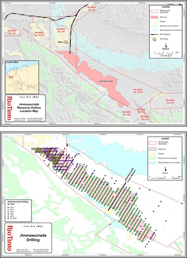
Page 25 of 42
|
||||||
| Balanced reporting |
• | Not applicable. Rio Tinto has not released exploration results for this deposit. | ||||
| Other substantive exploration data |
• | The area surrounding Mesa J deposit, including lower Jimmawurrada, was geologically mapped at 1:5,000 scale in 2003. The remainder of Jimmawurrada has been mapped from aerial photography with limited reconciliation by field checks. | ||||
| Further work | • | Further infill reverse circulation drilling is planned. The initial focus of this work is to collect data at the northwestern end of the deposit, near the Mesa J deposit. | ||||
| • | Further diamond core drilling is planned for dry density test work. | |||||
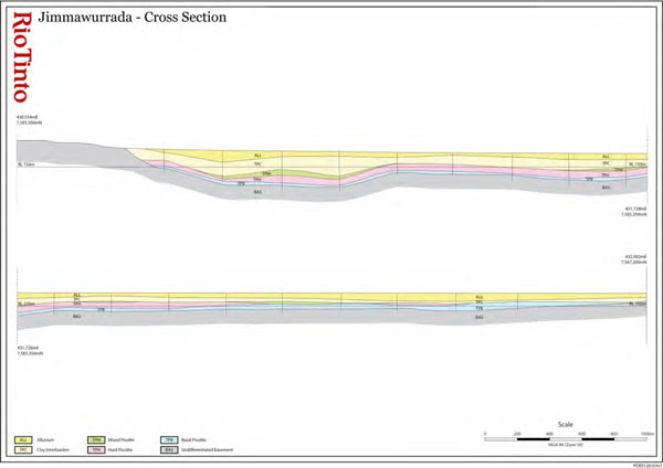
Page 26 of 42
| SECTION 3 ESTIMATION AND REPORTING OF MINERAL RESOURCES | ||||||||
| Criteria | Commentary | |||||||
| Database integrity |
• | All drilling data is securely stored in an acQuire™ geoscientific information management system managed by a dedicated team within Rio Tinto Iron Ore. The system is backed up nightly on servers located in Perth, Western Australia. The backup system has been tested in 2014, demonstrating that it is effective. | ||||||
| • | The drilling database used for Mineral Resource estimation has been internally validated by Rio Tinto Iron Ore personnel. Data is validated using acQuire™ scripts for relational integrity, duplicates, total assay and missing / blank assay values. | |||||||
| • | Data was exported from the acQuire™ database and imported into a Vulcan database. | |||||||
| • | The drill hole database is validated by/for: | |||||||
| ○ | acQuire™ scripts for relational integrity, duplicates, total assay and missing / blank assay values; | |||||||
| ○ | Grade ranges in each domain; | |||||||
| ○ | Domain names and tags; | |||||||
| ○ | Survey data down-hole consistency; | |||||||
| ○ | Null and negative grade values; | |||||||
| ○ | Missing or overlapping intervals; | |||||||
| ○ | Duplicate data. | |||||||
| • | Drill hole data is validated visually by domain compared to the geological model. | |||||||
| Site visits | • | The Competent Person visited Jimmawurrada in 2013. | ||||||
| Geological interpretation |
• | Overall the Competent Person’s confidence in the geological interpretation of the area is good, based on the quantity and quality of data available, and the continuity and nature of the mineralisation. | ||||||
| • | Geological modelling is undertaken by Rio Tinto Iron Ore geologists. The method involves interpretation of down-hole stratigraphy using surface geological mapping, lithological logging data, down-hole gamma data, and assay data. | |||||||
| • | Cross-sectional interpretation of each stratigraphic unit is performed followed by interpretation of mineralisation boundaries. Three-dimensional wireframes of the sectional interpretations are created to produce the geological model. | |||||||
| • | The geological model is subdivided into domains and the composites are coded with these domains. | |||||||
| • | In the Competent Person’s opinion the continuity of mineralisation is generally good. Mineralisation at Jimmawurrada is affected by stratigraphy, structure and weathering. The drill hole spacing is sufficient to capture grade and geology changes at a broad scale. | |||||||
| Dimensions | • | The mineralisation extends 18,000 m, is approximately 3,000 m wide, and is typically 15-70 m thick. | ||||||
| Estimation and modelling techniques |
• | Mineralised domains are estimated by ordinary kriging and non-mineralised domains are estimated by inverse distance weighting to the first power. These methods are deemed appropriate by the Competent Person for estimating the tonnes and grade of the reported Mineral Resources. | ||||||
| • | The estimation process was completed using Isatis and Vulcan computer software. | |||||||
| • | Grades are extrapolated to a maximum distance of approximately 500 m from data points. | |||||||
| • | The block model was rotated to align with the strike orientation of the deposit. | |||||||
| • | No grade capping or cutting was used, as analysis of the grade distributions of the attributes demonstrated it was not required. | |||||||
| • | The estimated model was validated using a combination of visual, statistical and multivariate global change of support techniques in the absence of any production data. | |||||||
| • | The block size used was 100 m (X) × 50 m (Y) × 4 m (Z) for parent blocks. | |||||||
| Moisture | • | All Mineral Resource tonnages are reported on a dry basis. | ||||||
| Cut-off parameters |
• | The criteria for Mineral Resources were that geology must be either mixed clay and pisolite or hard competent pisolite. | ||||||
Page 27 of 42
| Mining factors or assumptions |
• | Development of this Mineral Resource estimate assumes future mining using standard Rio Tinto Iron Ore equipment. The assumed mining method is conventional truck and shovel open pit mining at an appropriate bench height. Mining practices will include grade control utilising blast hole data. | ||||
| Metallurgical factors or |
• | Metallurgical testing was completed in 2014 that concluded the mixed clay and pisolite will process favourably, thus this geological domain is included as Mineral Resources. | ||||
| assumptions | • | It is assumed that standard crushing and screening processes used by Rio Tinto Iron Ore will be applicable for the processing of the Jimmawurrada deposit. | ||||
| Environmental factors or assumptions |
• | Rio Tinto Iron Ore has an extensive environmental and heritage approval process. A detailed review of these requirements has been undertaken in a recent Pre-Feasibility Study. No issues were identified that would impact on the Mineral Resource estimate. | ||||
| Bulk density | • | Dry bulk density was estimated using PQ3 diamond drillcore density measurements. | ||||
| • | Bulk density was assigned to mineralised blocks based on an average density for mineralised material. | |||||
| Classification | • | The Mineral Resource classification is 100% Inferred. | ||||
| • | The Competent Person is satisfied that the stated Mineral Resource classification reflects the geological controls interpreted and the estimation constraints of the deposits. | |||||
| Audits or reviews |
• | All stages of Mineral Resource estimation have undergone an internal peer review process, which has documented all phases of the process. The Mineral Resource estimate has been accepted by the Competent Person. | ||||
| Discussion of relative accuracy/ confidence |
• | The spacing of data at this stage only supports an Inferred Resource. | ||||
| • | Further density data needs to be collected to improve confidence in the estimated bulk density. | |||||
| • | The accuracy and confidence of Mineral Resource estimation is consistent with the current level of study (Order of Magnitude). |
Page 28 of 42
| Appendix 3 Koodaideri Table 1 | 6 March 2015 |
The following table provides a summary of important assessment and reporting criteria used at the Koodaideri deposits for the reporting of Mineral Resources and Ore Reserves in accordance with the Table 1 checklist in The Australasian Code for the Reporting of Exploration Results, Mineral Resources and Ore Reserves (The JORC Code, 2012 Edition). Criteria in each section apply to all preceding and succeeding sections.
SECTION 1 SAMPLING TECHNIQUES AND DATA
| Criteria | Commentary | |||||
| Sampling techniques |
• | Samples for geological logging, assay, geotechnical information, and metallurgical and density test work are collected via drilling. | ||||
| • | All reverse circulation drilling utilises a rotating cone splitter beneath a cyclone return system for sample collection. Samples typically weighed 4-5 kg. | |||||
| • | Geotechnical samples are collected via diamond core drilling of HQ (61 mm inside diameter). Samples are recovered using a triple-tube wireline system. | |||||
| • | Metallurgical sampling is performed by wide diameter diamond core drilling of 203 mm (recovery via pulling the entire rod string or PQ (85 mm diameter) using a triple-tube wireline system). | |||||
| • | Drilling is conducted on regularly spaced grids across the deposit. All intervals are sampled. | |||||
| • | Mineralisation is determined by a combination of geological logging and assay results. | |||||
| Drilling techniques |
• | Drilling is predominantly by reverse circulation (Refer to Section 2, Drill Hole Information, for a detailed breakdown of drilling by method and year). | ||||
| • | The majority of drilling is oriented vertically. | |||||
| • | Geotechnical diamond core was oriented using the ACE orientation tool, which marks the bottom of core at the end of each run. Acoustic and optical televiewer images were used in specific reverse circulation and diamond drill core holes throughout the deposit to acquire additional structural orientation data. | |||||
| • | All diamond drill core used triple tubes to hold/retrieve samples; HQ (61 mm) and PQ (83 mm) core was retrieved using a wire line on the sample tube, while Wide Diameter (203 mm) required conventional methods, due to weight. | |||||
| Drill sample recovery |
• | No direct recovery measurements of reverse circulation samples are performed. Sample weights are recorded from laboratory splits and the recovery at the rig is visually estimated for loss per drilling interval. | ||||
| • | Core recovery is recorded using rock quality designation (RQD) measurements with all cavities and core loss recorded by the driller. Overall recovery from diamond drill core exceeds 95% at the Koodaideri deposits. | |||||
| • | Based on analysis of field duplicate performance and overall grade distribution, it is unlikely that any significant bias exists between sample recovery and grades or material characteristics. | |||||
| Logging | • | All drill samples are geologically logged. | ||||
| • | HQ diamond core is logged geotechnically. | |||||
| • | All diamond drill core is photographed digitally and files stored on Rio Tinto network servers. | |||||
| • | All drill holes are logged using down-hole geophysical tools for gamma trace, calliper, gamma density, resistivity, magnetic susceptibility, and magnetic deviation. | |||||
| • | Open-hole, acoustic and optical televiewer data are collected at select drill hole locations for structural analyses. | |||||
Page 29 of 42
| Sub-sampling techniques and sample preparation |
Reverse circulation and percussion samples :
|
|||||
| • | The sample is oven dried at 105 degrees Celsius for a minimum of 24 hours. The sample is then crushed to approximately 3 mm using a Jaw Crusher and riffle split to produce a 500 g sub-sample. The sub-sample is pulverised to 95% of weight passing 150 µm. | |||||
| Diamond drill core samples: | ||||||
| • | Diamond drill core samples were crushed completely (full core sample) if they were to be assayed. | |||||
| Quality of assay data and laboratory tests |
Assay methods: | |||||
| • | All assaying of samples used in Mineral Resource estimates have been performed by independent, National Association of Testing Authorities (NATA) certified laboratories. | |||||
| • | Fe, SiO2, Al2O3, P, Mn, MgO, TiO2, CaO and S are assayed using industry standard lithium metaborate fusion and X-Ray Fluorescence (XRF) analysis. | |||||
| • | Loss on Ignition (LOI) is determined using industry standard Thermo-Gravimetric Analyser (TGA). | |||||
| Quality assurance measures include: | ||||||
| • | Insertion of certified reference standard by Rio Tinto geologists at a rate of one in every 25 samples with a minimum of one standard per drill hole. | |||||
| • | Field duplicates were inserted at a rate of one in 20 samples. | |||||
| • | Internal lab splits (post-crushing) and repeats (from pulps), at a rate of one in 20 samples. | |||||
| • | Random, blind re-submission of pulps following analysis at an external lab. | |||||
| • | Analysis of the performance of certified standard and field duplicates has indicated an acceptable level of accuracy and precision with no significant bias. | |||||
| Verification of sampling and assaying |
• | Drill hole core hole twins (twinning reverse circulation holes) have been completed throughout the deposit. | ||||
| • | Comparison of reverse circulation and twinned diamond drill core assay data distributions show that the drilling methods have similar grade distributions verifying the suitability of reverse circulation samples in the Mineral Resource estimate. | |||||
| • | Thorough documentation exists outlining the processes of geological logging and data importing, quality assurance and quality control procedures, validation, and assay importing, etc. | |||||
| Location of data points |
• | All drill hole collar locations at the Koodaideri deposits are surveyed using Geocentric Datum of Australia 1994 (GDA94) and Map Grid of Australia 1994 (MGA94) zone 50 by Rio Tinto surveyors using Differential Global Positioning System (DGPS) survey equipment. | ||||
| • | Drill hole collar reduced level (RL) data is compared to detailed topographic maps and show that the collar survey data is accurate. The topographic surface is based on 10 m grid sampling of the 2012 Light Detecting and Ranging (LiDAR) survey, including spot heights from DGPS drilling collars and is considered robust. | |||||
| • | Down-hole surveys were conducted on nearly every hole, with the exception of collapsed or otherwise hazardous holes; any significant, unexpected deviations were investigated and validated. Holes greater than 100 metres depth were generally surveyed with an in-rod gyro tool. | |||||
| • | A comparison of drill hole collar coordinates versus the LiDAR-based topographic surface found that all points matched within a two metre tolerance. | |||||
| Data spacing and distribution |
• | Koodaideri 75W and 58W: drill hole spacing is predominately 50 m × 50 m with some areas at 100 m × 50 m and 200 m × 50 m. Geotechnical diamond core drilling has been completed to intersect planned final pit walls. | ||||
| • | Koodaideri 38W and 21W: average drilling spacing is 400 m × 50 m. | |||||
Page 30 of 42
| Orientation of data in relation to geological structure |
• | Drill lines lie north-northeast to south-southwest (NNE-SSW) along MGA94 grid and perpendicular to the deposit strike. | ||||
| • | Reserve circulation drilling is predominantly vertical and intersects the gently undulating stratigraphy at right angles. | |||||
| • | Metallurgical holes were also vertical. | |||||
| • | Geotechnical diamond drill holes are angled with a maximum dip of -85 degrees. | |||||
| Sample security | • | Laboratory samples (A splits) are collected by field assistants, placed onto steel sample racks, and transported to laboratories in Perth, Western Australia for analyses. Retention samples (B splits) are collected and stored in drums for two years at on-site facilities. | ||||
| • | Assay pulps are retained indefinitely at Rio Tinto facilities located at two sites, Pannawonica or Dampier. | |||||
| Audits or reviews |
• | No external audits have been performed. | ||||
| • | Internal Rio Tinto Iron Ore peer review processes and internal Rio Tinto technical reviews have been completed. These reviews concluded that the fundamental data collection techniques are appropriate. | |||||
Page 31 of 42
SECTION 2 REPORTING OF EXPLORATION RESULTS
| Criteria | Commentary | ||||||||||||||||
| Mineral tenement and land tenure status | • | 100% owned by Hamersley Iron Proprietary Limited (100% Rio Tinto Limited), held under Mining Lease (ML) 252SA Section 1 to 4. | |||||||||||||||
| Exploration done by other parties | • | Initial exploration drilling at Koodaideri 38W and 21W was undertaken by Mt. Bruce Mining Limited during the 1970’s. This data has not been used in the Mineral Resource estimate as a result of investigations indicating that the assay data was biased. | |||||||||||||||
| Geology | • | The deposit type is a bedded iron ore deposit hosted in the Dales Gorge Member of the Archean Brockman Iron Formation. | |||||||||||||||
| • | Mineralisation occurs as a high-phosphorous Brockman Iron deposit with a weathering overprint. | ||||||||||||||||
| Drill hole Information |
• | Drilling data summary: | |||||||||||||||
| Diamonds | Reverse Circulation | ||||||||||||||||
| Year | |||||||||||||||||
| # Holes | Metres | # Holes | Metres | ||||||||||||||
| 2002 | 57 | 4,956 | |||||||||||||||
| 2003 | 8 | 514 | |||||||||||||||
| 2010 | 58 | 3,705 | |||||||||||||||
| 2011 | 47 | 2,720 | 1,961 | 122,390 | |||||||||||||
| 2012 | 56 | 2,721 | 2,112 | 135,015 | |||||||||||||
| 2013 | 444 | 24,468 | |||||||||||||||
| Total | 111 | 5,955 | 4,632 | 290,534 | |||||||||||||
| Data aggregation methods |
• | All assay, geology, and density data have been composited to 2 m for Mineral Resource modelling and estimation. | |||||||||||||||
| • | No grade truncations are performed. | ||||||||||||||||
| Relationship between mineralization widths and intercept lengths |
• | Down-hole sample lengths are reported which are essentially true width due to predominantly vertical drilling and gently folded strata with an average dip of 10 degrees. | |||||||||||||||
Page 32 of 42
| Diagrams | 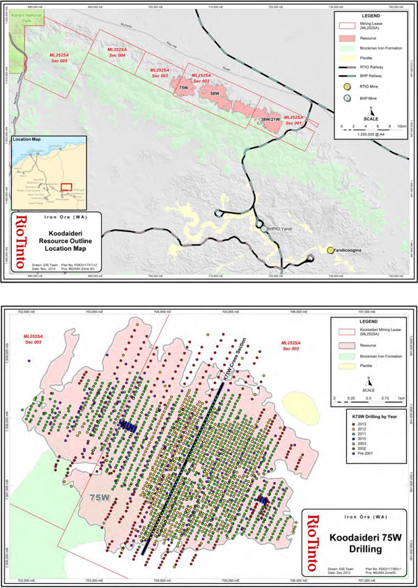 |
|||
Page 33 of 42
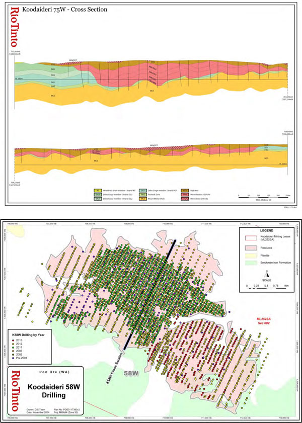 |
|||
Page 34 of 42
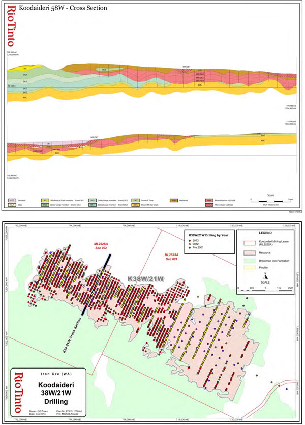 |
|||
Page 35 of 42
|
|
||||||
| Balanced reporting |
• | Not applicable. Rio Tinto has not specifically released exploration results for these deposits. | ||||
| Other substantive exploration data |
• | Geological surface mapping data has been collected across the Koodaideri area in 2006, 2007, 2009, and 2013 at 1:5,000 scale. | ||||
| Further work | • |
Further infill reverse circulation drilling is planned for all deposits to a planned spacing of 50 m × 50 m.
|
||||
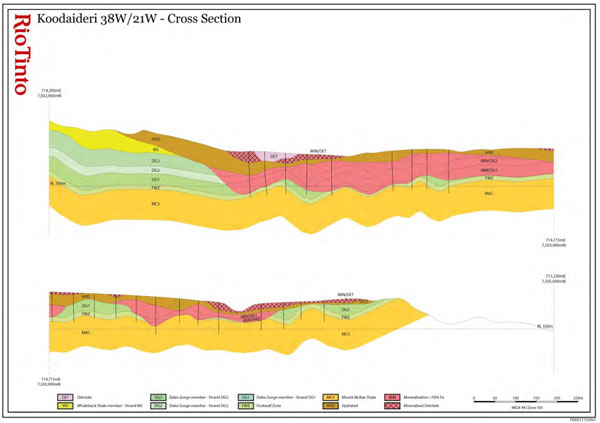
Page 36 of 42
SECTION 3 ESTIMATION AND REPORTING OF MINERAL RESOURCES
| Criteria | Commentary | ||||||
| Database integrity |
• | All drilling data is securely stored in an acQuire™ geoscientific information management system managed by a dedicated team within Rio Tinto Iron Ore. The system is backed up nightly on servers located in Perth, Western Australia. The backup system has been tested in 2014, demonstrating that the system is effective. | |||||
| • | The drilling database used for Mineral Resource estimation has been internally validated by Rio Tinto Iron Ore personnel using acQuire™ scripts for relational integrity, duplicates, total assay and missing and blank assays. | ||||||
| • | Additional drill hole assay data are validated by: | ||||||
| ○ | Grade ranges in each domain | ||||||
| ○ | Domain names and tags | ||||||
| ○ | Survey data down-hole consistency | ||||||
| ○ | Null and negative grade values | ||||||
| ○ | Missing or overlapping intervals | ||||||
| ○ | Duplicate data. | ||||||
| Site visits | • | The Competent Person visited Koodaideri in 2013. There were no outcomes as a result of this visit. | |||||
| Geological interpretation |
• | Overall confidence in the geological interpretation of the area is good, based on quantity and quality of data available. | |||||
| • | Geological modelling is undertaken by Rio Tinto geologists. The method involves interpretation of down-hole stratigraphy using surface geological mapping, lithological logging data, down-hole gamma data, and assay data. | ||||||
| • | Cross-sectional interpretation of each stratigraphic unit is performed followed by interpretation of mineralisation and hydration boundaries. Three-dimensional wireframes of the sectional interpretations are created to produce the geological model. | ||||||
| • | The geological model is subdivided into domains and both the composites and model blocks are coded with these domains. Blocks in domains are estimated using composites from the same domain. | ||||||
| • | Mineralisation is continuous. It is effected by stratigraphy, structure and weathering. The drill hole spacing is sufficient to capture grade and geology changes at a large scale. | ||||||
| Dimensions | • | The mineralisation extends 4.5 km (58W and 75W) or 8.6 km (38W/21W) along strike in a west-northwest to east-southeast (WNW-ESE) direction, up to 2.5 km (58W and 75W) or 2.8 km (38W/21W) across strike in a north-northeast to south-southwest (NNE-SSW) direction and to a maximum depth of 100 m below the current topographical surface (averaging 75 m in depth). | |||||
| • | The hardcap (weathering) overprint extends across the deposits, varying in depth from 2m to 40 m below the current topographical surface (averaging 20 m in depth). | ||||||
| Estimation and modelling techniques |
• | Mineralised domains are estimated by ordinary kriging and non-mineralised domains are estimated by inverse distance weighting to the first power. These methods are appropriate for estimating the tonnes and grade of the reported Mineral Resources. | |||||
| • | The geological model is used to construct hard-boundary domains used for estimation. | ||||||
| • | The estimation process was completed using Isatis and Vulcan computer software. | ||||||
| • | Grades are extrapolated to a maximum distance of approximately 400 m from data points. | ||||||
| • | Block models are rotated to align with the orientation of the deposits. | ||||||
| • | A ‘high yield limit’ or grade dependent restriction on a sample’s range of influence was used for manganese. The limits differed for different domains and were selected based on histograms and spatial distribution of manganese data. | ||||||
| • | No other grade capping or cutting was applicable. | ||||||
| • | The estimated model was validated using a combination of visual, statistical and global | ||||||
Page 37 of 42
| change of support techniques as there are no production data for reconciliation. | ||||||
| • | Koodaideri 75W & 58W: block size of 25 m E (Easting) × 25 m N (Northing) × 5 m RL (elevation) for parent blocks. Parent blocks are sub-celled to the geological boundaries to preserve volume. | |||||
| • | Koodaideri 38W and 21W: Block sizes are 100 m E × 25 m N × 5 m RL for parent blocks. Parent blocks are sub-celled to the geological boundaries to preserve volume. | |||||
| Moisture | • | All Mineral Resource tonnages are reported on a dry basis. | ||||
| Cut-off | • | The cut-off grade for High-Grade ore is greater than or equal to 60% Fe. | ||||
| parameters | • | The cut-off for Brockman Process Ore is material 50% ≤ Fe < 60% and ≥ 3% Al2O3 < 6% (geology domain must be Dales Gorge, Joffre or Footwall Zone). | ||||
| Mining factors or assumptions |
• | Development of this Mineral Resource assumes mining using standard Rio Tinto Iron Ore equipment and methods similar to other Pilbara iron ore mines. The assumed mining method is conventional truck and shovel open pit mining at an appropriate bench height. Mining practices will include grade control utilising blast hole data. | ||||
| Metallurgical factors or assumptions |
• | It is assumed that standard dry crush and screening processes used by Rio Tinto Iron Ore will be applicable for the processing of the Koodaideri deposit. | ||||
| Environmental factors or assumptions |
• | Rio Tinto Iron Ore has an extensive environmental and heritage approval process. A detailed review of these requirements has been undertaken in a recent Pre-Feasibility Study. No issues were identified that would impact on the Mineral Resource estimate. | ||||
| Bulk density | • | Koodaideri 75W and 58W: Dry bulk density is derived from accepted gamma-density data collected at 10 cm intervals from down-hole geophysical sondes. Accepted gamma- density data is corrected for moisture using diamond drill core specifically drilled throughout the deposit. | ||||
| • | Dry core densities are generated via the following process. The core volume is measured in the split and the mass of the core is measured and recorded. Wet core densities are calculated by the split and by the tray. The maximum length of sample for each density measurement is 1.5 m. Core recovery, core loss and core gain are all recorded and accounted for. The core is then dried and dry core masses are measured and recorded. Dry core densities are then calculated. | |||||
| • | Koodaideri 38W and 21W: No dry core density data is available. Density values are assigned to each mineralised domain using data from the adjacent Koodaideri 58W deposit. | |||||
| • | Bulk density was estimated using ordinary kriging in mineralised zones and inverse distance weighted to the first power in non-mineralised zones. | |||||
| Classification | • | The Mineral Resource includes the classifications: Measured, Indicated, and Inferred with additional material (greater than 50% Fe) set as unclassified. | ||||
| • | Koodaideri 75W and 58W are predominantly Measured Mineral Resources while the wider drill spacing at Koodaideri 38W and 21W results in these deposits being predominantly Inferred Mineral Resources. | |||||
| • | The Competent Person is satisfied that the stated Mineral Resource classification reflects the data spacing, data quality, level of geological continuity and the estimation constraints of the deposits. | |||||
| Audits or reviews |
• | All stages of Mineral Resource estimation have undergone a documented internal peer review process. The Mineral Resource estimate has been accepted by the Competent Person. | ||||
| Discussion
of relative accuracy/ |
• | Rio Tinto Iron Ore operate multiple mines in the Pilbara region of Western Australia. The Mineral Resource data collection and estimation techniques used for Koodaideri are consistent with those applied at other deposits which are being mine. Reconciliation of |
Page 38 of 42
| confidence | actual production with the Mineral Resource estimates for individual deposits is generally accurate to within ten percent for tonnes on an annual basis. This result is indicative of a robust process. | |||||
| • | The accuracy and confidence of the Mineral Resource estimate is consistent with the current level of study (Pre-Feasibility Study). | |||||
SECTION 4 ESTIMATION AND REPORTING OF ORE RESERVES
| Criteria | Commentary | |||||
| Mineral Resource estimate for conversion to Ore Reserves |
• | Initial generation of the modifying factors for this Ore Reserve estimate were based on a Mineral Resource estimate completed in April 2012. Subsequent to the completion of the Pre-Feasibility Study an updated Mineral Resource estimate was completed (incorporating more recent drilling information) in 2014 which formed the basis for a redesign of the open pits. The most recent Mineral Resource estimate together with the latest update of pit designs were used for reporting Ore Reserves. | ||||
| • | The declared Ore Reserves are for the Koodaideri 58 west and 75 west deposits. | |||||
| • | Mineral Resources are reported additional to Ore Reserves. | |||||
| Site visits | • | The Competent Person visited Koodaideri in 2013. | ||||
| Study status | • | A Pre-Feasibility Study was completed in 2013. A Feasibility Study is in progress. | ||||
| Cut-off parameters |
• | The cut-off grade for high-grade Brockman ore is greater than or equal to 60% Fe. | ||||
| Mining factors or assumptions |
• | The Mineral Resource model was regularised to a block size of 25 m E × 25 m N × 10 m RL which was determined to be the selective mining unit following an analysis of a range of selective mining units. Dilution and mining recovery were modelled by applying the regularisation process to the sub-block geological model. | ||||
| • | Metallurgical models were applied to the regularised model in order to model products tonnage, grades and yields. | |||||
| • | Pit optimisations utilising the Lerchs-Grosmann algorithm with industry standard software were undertaken. This optimisation utilised the regularised Mineral Resource model together with cost, revenue, and geotechnical inputs. The resultant pit shells were used to develop detailed pit designs with due consideration of geotechnical, geometric and access constraints. These pit designs were used as the basis for production scheduling and economic evaluation. | |||||
| • | Conventional mining methods (truck and shovel) similar to other Rio Tinto Iron Ore mines were selected. The mine has been designed to utilise in-pit crushing and conveying to transport ore to a central processing facility. | |||||
| • | The geotechnical parameters have been applied based on geotechnical studies informed by assessments of 50 drill holes drilled during the 2011, 2012 & 2013 drilling programmes, specifically drilled for geotechnical purposes on the surrounding host rock. The resultant inter ramp slope angles vary between 16 and 35 degrees depending on the local rock mass and structural geological conditions. | |||||
| • | During the above process, Inferred Mineral Resources were excluded from mine schedules and economic valuations utilised to validate the economic viability of the Ore Reserves. | |||||
| • | The Pre-Feasibility Study considered the infrastructure requirements associated with the conventional truck and shovel mining operation including crushing and conveying systems, dump & stockpile locations, maintenance facilities, access routes, explosive storage, water, and power. | |||||
| Metallurgical factors or assumptions |
• | The Koodaideri mine has been designed with a dry crush and screen processing facility similar to processing facilities at other Rio Tinto Iron Ore mining operations. Studies into alternative processing technologies continue, however this has been excluded from this ore reserve declaration. | ||||
Page 39 of 42
| • | The proposed metallurgical process is a well-tested and proven processing methodology, having been utilised at Rio Tinto Iron Ore mining operations for decades. | |||||
| • | During drill campaigns in 2003, 2011, 2012 and 2013 a total of 4,857 m of metallurgical diamond drill core (2858m PQ and 1999m Wide Diameter) were drilled in the K58W and K75W deposits and to a lesser extent K21W and K38W. Data obtained from this core formed the basis for metallurgical test work which informed the study for the design of the processing facility and metallurgical models. The map below show the location of these drill holes. | |||||
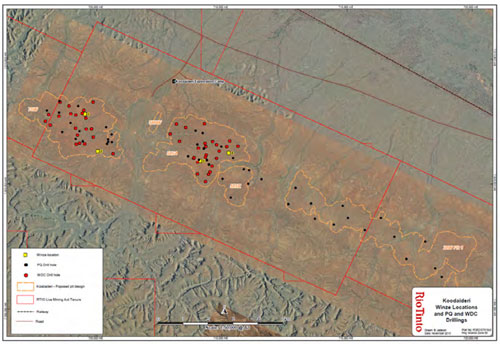 |
||||||
| • | The diamond drill core test results were utilised to develop metallurgical models representing different metallurgical domains which were considered representative of the ore body. The metallurgical models predict product tonnage and grade parameters for lump and fines products. | |||||
| Environmental | • | Rio Tinto Iron Ore referred the Koodaideri project to the Environmental Protection Agency on 28 May 2012, followed by the Commonwealth referral on 5 June 2012. The Koodaideri project was given a level of assessment of a Public Environmental Review under Part IV of the Environmental Protection Act 1986. The Koodaideri project was also determined to be a controlled action under the Commonwealth Environment Protection and Biodiversity Conservation Act 1999. The project is being assessed by the State under the bilateral assessment process agreed with the Commonwealth. State and Commonwealth environmental approvals and conditions are expected to be granted in 2015. | ||||
| • | A geochemical risk assessment has been completed for the project. The assessment encompasses all material types present at the site, and tests have been conducted in accordance with industry standards. Mining operations at the project pose a low acid mine drainage risk based on current pit designs and the assessment of samples from within the pit locations. | |||||
| Infrastructure | • | Access to the site during construction will be from the Great Northern Highway and then along the Roy Hill Road. A second access road from the south will be link the existing Yandicoogina Access Road to the Koodaideri operations. |
Page 40 of 42
| • | Ore will be railed to Rio Tinto’s ports at Dampier and Cape Lambert. Upon completion of current and planned/approved construction projects, the port and railway networks will have sufficient capacity to accommodate ore supply from Koodaideri. | |||||
| • | Main fuel freight and supply for ammonium nitrate and fuel oil (ANFO) will access Koodaideri via the Roy Hill Road. Fly-in, Fly-out (FIFO) personnel access will be via the southern corridor access road from Barimunya Airport. | |||||
| • | Designs for buildings, explosives storage, workshops and related facilities proposed for the Koodaideri project have been modelled on existing Rio Tinto Iron Ore facilities, with changes included as a result of operating experience. | |||||
| • | A central hub for all non-process support facilities, will be located close the existing Munjina- Roy Hill road for ease of access. It is located central to the mine, processing plant and accommodation precinct. | |||||
| • | The Koodaideri Explosive Facility is located south of the K58W pit and will be similar to ones constructed at recent Rio Tinto Iron ore projects in the Pilbara, Western Australia. | |||||
| • | Electric power will be supplied to Koodaideri from the Rio Tinto transmission network via linking into an existing Rio Tinto 220 kV transmission line between Juna Downs and Yandicoogina. | |||||
| • | Water for Koodaideri will be initially sourced from bores located to the east of Koodaideri together with other surrounding bores at Koodaideri. These bores will support the early works and construction activities water demands. | |||||
| Costs | • | The capital costs are based on a Preliminary Engineering Study utilising experience from the construction of existing similar Rio Tinto Iron Ore projects in the Pilbara, Western Australia. | ||||
| • | Operating costs were benchmarked with similar operating Rio Tinto Iron Ore mine sites. | |||||
| • | Exchange rates were forecast by analysing and forecasting macro-economic trends in the Australian and World economy. | |||||
| • | Transportation costs were based on existing operating experience at Rio Tinto Iron Ore mine sites in the Pilbara, Western Australia. | |||||
| • | Allowances have been made for royalties to the Western Australian government and other private stakeholders. | |||||
| Revenue factors | • | Rio Tinto applies a common process to the generation of commodity prices across the group. This involves generation of long-term price curves based on current sales contracts, industry capacity analysis, global commodity consumption and economic growth trends. In this process, a price curve rather than a single price point is used to develop estimates of mine returns over the life of the project. The detail of this process and of the price point curves is commercially sensitive and is not disclosed. | ||||
| Market assessment |
• | The supply and demand situation for iron ore is affected by a wide range of factors, and as iron and steel consumption changes with economic development and circumstances. Rio Tinto Iron Ore delivers products aligned with its Mineral Resources and Ore Reserves, these products have changed over time and successfully competed with iron ore products supplied by other companies. | ||||
| Economic | • | Economic inputs such as foreign exchange rates, carbon pricing, and inflation rates are also generated internally at Rio Tinto. The detail of this process is commercially sensitive and is not disclosed. | ||||
| • | Sensitivity testing of the Koodaideri Ore Reserves using both Rio Tinto long-term prices and a range of published benchmark prices demonstrates a positive net present value for the project sufficient to meet Rio Tinto Limited investment criteria. | |||||
| Social | • | The Koodaideri deposits are located within existing tenure Mining Lease (ML)252SA, which was granted under the Iron Ore (Mount Bruce) Agreement Act 1972 (Mount Bruce SA). | ||||
| • | Additional tenure is required to connect the mine with the existing Rio Tinto Iron Ore rail network, as well as for roads, power, water and camp locations located outside of the Mining Lease. Rio Tinto Iron Ore is currently in the process of negotiating third party consent to facilitate the grant of tenure for rail and ancillary infrastructure corridors. |
Page 41 of 42
| • | The Koodaideri mine and most of the proposed associated infrastructure falls within the area of the Banjima group’s registered native title claim. The north-west rail option route lies within the Yindjibarndi group which has both determined native title and a registered native title claim. | |||||
| • | The Koodaideri project is located in the Hamersley Range, which has a deep and rich history of Aboriginal occupation. In total, six ethnographic surveys and 24 archaeological surveys have been completed to date in which a total of 316 heritage sites have been identified. The locations of these sites were considered during mine planning and engineering activities. | |||||
| • | Rio Tinto Iron Ore has undertaken environmental surveys across the project area to support the development of the Koodaideri project including flora and vegetation and vertebrate fauna surveys, troglofauna sampling and an assessment of bat colonies and aquatic habitats. | |||||
| • | A number of native vegetation clearing permits have been granted by the Western Australian Department of Mines and Petroleum (DMP) to allow for preliminary works such as sterilization drilling, geotechnical investigations, mineral exploration, a construction camp, and associated activities. | |||||
| • | The Koodaideri deposits and associated infrastructure are located within the Shire of Ashburton and the Shire of East Pilbara. Rio Tinto Iron Ore has established engagement frameworks with the Shire of Ashburton and the Shire of East Pilbara which includes scheduled meetings and project updates. Engagement with both Shires on Koodaideri has been established and will be ongoing throughout the project. | |||||
| Other | • | Semi-quantitative risk assessments have been undertaken throughout the Koodaideri study phases, no material naturally occurring risks have been identified through the above mentioned risk management processes. | ||||
| • | The mine and associated rail routes require additional tenure. Negotiations are ongoing with third parties and are generally progressing satisfactorily. | |||||
| Classification | • | The Ore Reserves consist of 54% Proved Reserves and 46% Probable Reserves. | ||||
| • | The Competent Person is satisfied that the stated Ore Reserve classification reflects the outcome of technical and economic studies. | |||||
| Audits or reviews | • | No external audits have been performed. | ||||
| • | Internal Rio Tinto Iron Ore peer review processes and internal Rio Tinto technical reviews have been completed. These reviews concluded that the fundamental data collection techniques are appropriate. | |||||
| Discussion of
relative
accuracy/ confidence |
• | Rio Tinto Iron Ore operates multiple mines in the Pilbara region of Western Australia. The Ore Reserve estimation techniques utilised for the Koodaideri deposits are consistent with those applied at the existing operations. Reconciliation of actual production with the Ore Reserve estimate for individual deposits is generally within 10 percent for tonnes on an annual basis. This result is indicative of a robust Ore Reserve estimation process. | ||||
| • | Accuracy and confidence of modifying factors are generally consistent with the current level of study (Pre-Feasibility Study). It is anticipated that the modifying factors will be further refined during the Feasibility Study which is currently under way. |
Page 42 of 42
|
|
Media Release |
Rio Tinto paid US$7.1 billion in taxes in 2014
16 March 2015
Rio Tinto has published its latest Taxes paid report, detailing the US$7.1 billion in taxes paid by the company around the world in 2014.
Rio Tinto is a global leader in providing detailed information about the taxes paid in the jurisdictions in which it operates globally and has produced an annual Taxes paid report for the past five years.
The voluntary report shows that Rio Tinto continues to make a significant contribution to public finances around the world and details all payments over US$1 million made to governments in the countries where Rio Tinto operates.
The majority of Rio Tinto’s taxes and royalties in 2014 were paid in Australia (US$5.6b), Canada (US$432m), Chile (US$262m), United States (US$211m), Mongolia (US$185m), South Africa (US$110m), France (US$106m), Guinea (US$67m), Singapore (US$44m) and UK (US$29m).
The report shows last year’s global effective tax rate was 43 per cent. Between 2010 and 2014, the company paid an average effective rate of about 42.5 per cent.
Rio Tinto chief financial officer Chris Lynch said “Rio Tinto continues to be a major contributor to the economies of its host nations. Through our tax and royalty contribution, investments, employment, local purchasing and contracting, we are a major generator of wealth and economic activity. We are very proud of this record.
“The Taxes paid report is important evidence of our commitment to taxation transparency. We were a founding member of the Extractive Industries Transparency Initiative and strongly advocate the need to appropriately disclose payments to governments around the world.
“2014 has been a year of significant change in the international tax landscape, with a particular focus on efforts to eliminate Base Erosion and Profit Shifting (BEPS). Rio Tinto agrees with the aims of these efforts. Governments must also be mindful not to inadvertently damage the investment environment when implementing BEPS proposals.
“To tackle BEPS issues effectively, we must adopt a coherent global approach and improve cross-border cooperation rather than take unilateral action that adds to compliance costs and dampens trade and investment.”
See the full report - www.riotinto.com/taxespaidin2014
Page 1 of 2
![]()
Contacts
www.riotinto.com
![]() Follow @RioTinto
on Twitter
Follow @RioTinto
on Twitter
| Media Relations, EMEA / Americas | Media Relations, Australia / Asia |
| Illtud Harri | Ben Mitchell |
| T +44 20 7781 1152 | T +61 3 9283 3620 |
| M +44 7920 503 600 | M +61 419 850 212 |
| David Outhwaite | Bruce Tobin |
| T +44 20 7781 1623 | T +61 3 9283 3612 |
| M +44 7787 597 493 | M +61 419 103 454 |
| David Luff | Matthew Klar |
| T +44 20 7781 1177 | T +61 7 3625 4244 |
| M +44 7780 226 422 | M +61 457 525 578 |
| Investor Relations, EMEA / Americas | Investor Relations, Australia / Asia |
| John Smelt | Rachel Storrs |
| T +44 20 7781 1654 | T +61 3 9283 3628 |
| M +44 7879 642 675 | M +61 417 401 018 |
| David Ovington | Galina Rogova |
| T +44 20 7781 2051 | T +852 2839 9208 |
| M +44 7920 010 978 | M +852 6978 3011 |
| Grant Donald | |
| T +44 20 7781 1262 | |
| M +44 7920 587 805 |
| Rio Tinto plc | Rio Tinto Limited |
| 2 Eastbourne Terrace | 120 Collins Street |
| London W2 6LG | Melbourne 3000 |
| United Kingdom | Australia |
| T +44 20 7781 2000 | T +61 3 9283 3333 |
| Registered in England | Registered in Australia |
| No. 719885 | ABN 96 004 458 404 |
Page 2 of 2
Serious News for Serious Traders! Try StreetInsider.com Premium Free!
You May Also Be Interested In
- Rio Tinto plc (RIO) 30-day option implied volatility near low end of range
- Broadvoice Wins 2024 Bronze Stevie Award for Excellence in Customer Service
- Oconee Federal Financial Corp. Announces Quarterly Dividend
Create E-mail Alert Related Categories
SEC FilingsSign up for StreetInsider Free!
Receive full access to all new and archived articles, unlimited portfolio tracking, e-mail alerts, custom newswires and RSS feeds - and more!